TopoQuest Logo
Do you find TopoQuest useful?
Help keep TopoQuest running and adding new maps/features by donating!
Bitcoin:  19c7KJd3qBynnjoSw5npx9KScwjBe4ifkT
Litecoin:  LXs6TkuXGGXo1vDsWCkWVdjQX94eUKd6ui
Home View Maps Find Maps Find Places Resources & Links


Berryville, Arkansas Topographic Map

USGS Map Title: Berryville, AR
USGS Map MRC: 36093C5
DRG (GeoTIFF) Download: o36093c5.tif


Neighboring USGS Topographic Map Quads:


  Eureka Springs, AR  
36093D6
 

  Grandview, AR  
36093D5
 

  Blue Eye, AR  
36093D4
 

  Rockhouse, AR  
36093C6
 

  Berryville, AR  
36093C5
 

  Green Forest, AR  
36093C4
 

  Forum, AR  
36093B6
 

  Marble, AR  
36093B5
 

  Osage, AR  
36093B4


Map MRC Location:

N37°
W94°
N37°
W93°
H8 H7 H6 H5 H4 H3 H2 H1
G8 G7 G6 G5 G4 G3 G2 G1
F8 F7 F6 F5 F4 F3 F2 F1
E8 E7 E6 E5 E4 E3 E2 E1
D8 D7 D6 D5 D4 D3 D2 D1
C8 C7 C6 C5 C4 C3 C2 C1
B8 B7 B6 B5 B4 B3 B2 B1
A8 A7 A6 A5 A4 A3 A2 A1
N36°
W94°
N36°
W93°

Berryville, AR USGS 1:24K Topographic Map Preview:
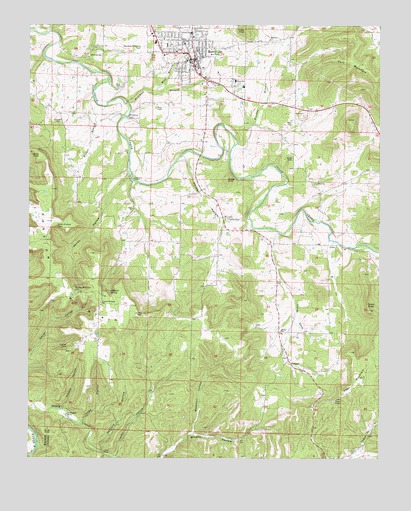
Berryville, AR USGS Topographic Map
Click on map above to begin viewing in our Map Viewer.

This topographic map contains these locations and features:
Feature Name Type Latitude Longitude GNIS ID View Map
Applegate FordCrossingN36.2631°W93.6110°56907View Map
BerryvillePopulated PlaceN36.3648°W93.5680°46413View Map
Berryville Elementary SchoolSchoolN36.3723°W93.5841°69192View Map
Berryville Fire DepartmentBuildingN36.3687°W93.5700°2116143View Map
Berryville High SchoolSchoolN36.3726°W93.5840°69193View Map
Berryville Memorial CemeteryCemeteryN36.3684°W93.5849°46414View Map
Berryville Middle SchoolSchoolN36.3720°W93.5838°2039013View Map
Berryville Police DepartmentBuildingN36.3648°W93.5649°2118858View Map
Berryville United Methodist ChurchChurchN36.3673°W93.5730°1959664View Map
Briley CemeteryCemeteryN36.3359°W93.5316°46957View Map
CabanalPopulated PlaceN36.2784°W93.5321°76483View Map
Canfield HollowValleyN36.2531°W93.5991°47445View Map
Carroll CountyCivilN36.3410°W93.5382°66975View Map
Carroll County CourthouseBuildingN36.3648°W93.5691°69196View Map
Carroll County Sheriff's OfficeBuildingN36.3555°W93.5465°2118857View Map
Carroll General Hospital HeliportAirportN36.3590°W93.5521°83642View Map
Carroll Regional Medical CenterHospitalN36.3589°W93.5520°2092847View Map
City of BerryvilleCivilN36.3714°W93.5705°2403863View Map
Cove ChurchChurchN36.3220°W93.5882°48099View Map
Farmer CemeteryCemeteryN36.3192°W93.5546°49008View Map
Farmer HollowValleyN36.3328°W93.5677°49009View Map
First Baptist ChurchChurchN36.3631°W93.5652°69211View Map
First Christian ChurchChurchN36.3659°W93.5638°69212View Map
First Freewill Baptist ChurchChurchN36.3601°W93.5724°69213View Map
First Presbyterian ChurchChurchN36.3642°W93.5694°69214View Map
Fort MountainSummitN36.3651°W93.5149°57763View Map
Freeman BranchStreamN36.3526°W93.5905°49237View Map
Freeman Heights Baptist ChurchChurchN36.3709°W93.5774°69216View Map
Gage MountainSummitN36.2737°W93.5055°49298View Map
Hailey HollowValleyN36.3259°W93.5963°49757View Map
Harris PointCliffN36.3370°W93.6213°49906View Map
Hill ChurchChurchN36.3462°W93.5321°50115View Map
Indigo KnobSummitN36.3737°W93.5485°57969View Map
Jackson LakeReservoirN36.2934°W93.5135°80925View Map
Jackson Lake DamDamN36.2934°W93.5135°80924View Map
Johnson SpringSpringN36.2981°W93.5960°50706View Map
Kittner HollowValleyN36.2651°W93.6121°50890View Map
KTHS-AM (Berryville)TowerN36.3617°W93.5613°85280View Map
Lead HollowValleyN36.2615°W93.6052°51026View Map
Littrel FordCrossingN36.2515°W93.5980°58077View Map
Lucky GapGapN36.2915°W93.5844°51510View Map
Lucky HollowValleyN36.2515°W93.5930°51511View Map
McKennon FordCrossingN36.3487°W93.5907°58153View Map
Mercy Hospital BerryvilleHospitalN36.3589°W93.5518°69197View Map
Mill BranchStreamN36.3562°W93.5832°51976View Map
Moore CemeteryCemeteryN36.2862°W93.5335°1959674View Map
Moore ChurchChurchN36.2870°W93.5352°52163View Map
Moore School (historical)SchoolN36.2873°W93.5355°69229View Map
Mulberry ChurchChurchN36.3709°W93.5399°52537View Map
Pension MountainSummitN36.3020°W93.6155°58346View Map
Pension Mountain CemeteryCemeteryN36.2976°W93.6082°53273View Map
Pension Mountain SchoolSchoolN36.2951°W93.5994°53274View Map
Rush CemeteryCemeteryN36.3509°W93.5802°54278View Map
Simmons FordCrossingN36.3301°W93.5880°58626View Map
Snow CemeteryCemeteryN36.3287°W93.5221°1959676View Map
Snow ChurchChurchN36.3292°W93.5227°54986View Map
Snow KnobSummitN36.2928°W93.5041°54988View Map
Sugarcamp HollowValleyN36.2506°W93.6238°55311View Map
Township of CabanalCivilN36.2866°W93.5252°66890View Map
Township of PrairieCivilN36.3450°W93.5868°66909View Map
Warden BranchStreamN36.3403°W93.5519°56052View Map
Waterfall HollowValleyN36.2581°W93.5660°56090View Map
Westside Christian ChurchChurchN36.3612°W93.5713°69246View Map
Wilder BranchStreamN36.3545°W93.6024°56370View Map
Woods KnobSummitN36.3303°W93.5549°58913View Map

Note: Coordinates in the location and feature list above are referenced to NAD83 datum.


Copyright (C) 2008-2025 Ryan Niemi / Sunset Dynamics ... All Rights Reserved