TopoQuest Logo
Do you find TopoQuest useful?
Help keep TopoQuest running and adding new maps/features by donating!
Bitcoin:  19c7KJd3qBynnjoSw5npx9KScwjBe4ifkT
Litecoin:  LXs6TkuXGGXo1vDsWCkWVdjQX94eUKd6ui
Home View Maps Find Maps Find Places Resources & Links


Guinn Cross Roads, Alabama Topographic Map

USGS Map Title: Guinn Cross Roads, AL
USGS Map MRC: 34087D8
DRG (GeoTIFF) Download: o34087d8.tif


Neighboring USGS Topographic Map Quads:


  Pleasant Site, AL  
34088E1
 

  Pleasant Grove, AL  
34087E8
 

  Frankfort, AL  
34087E7
 

  Halltown, AL  
34088D1
 

  Guinn Cross Roads, AL  
34087D8
 

  Isbell, AL  
34087D7
 

  Vina, AL  
34088C1
 

  Hodges, AL  
34087C8
 

  Hackleburg, AL  
34087C7


Map MRC Location:

N35°
W88°
N35°
W87°
H8 H7 H6 H5 H4 H3 H2 H1
G8 G7 G6 G5 G4 G3 G2 G1
F8 F7 F6 F5 F4 F3 F2 F1
E8 E7 E6 E5 E4 E3 E2 E1
D8 D7 D6 D5 D4 D3 D2 D1
C8 C7 C6 C5 C4 C3 C2 C1
B8 B7 B6 B5 B4 B3 B2 B1
A8 A7 A6 A5 A4 A3 A2 A1
N34°
W88°
N34°
W87°

Guinn Cross Roads, AL USGS 1:24K Topographic Map Preview:
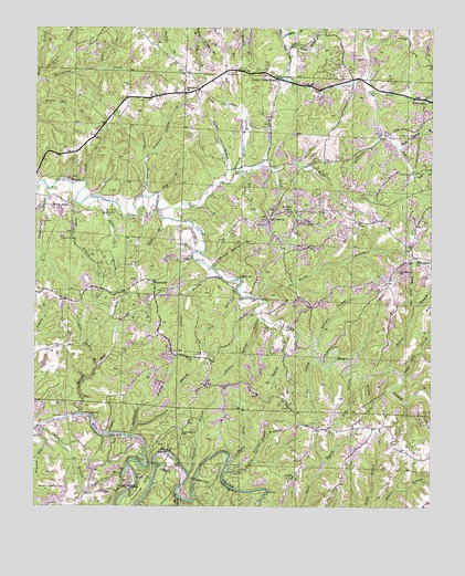
Guinn Cross Roads, AL USGS Topographic Map
Click on map above to begin viewing in our Map Viewer.

This topographic map contains these locations and features:
Feature Name Type Latitude Longitude GNIS ID View Map
Baggett CemeteryCemeteryN34.3801°W87.9925°113336View Map
Bear Creek DamDamN34.3984°W87.9878°113677View Map
Bear Creek ReservoirReservoirN34.3884°W87.9429°113679View Map
Beck BranchStreamN34.4976°W87.9503°113777View Map
Blackridge BranchStreamN34.4734°W87.8911°114449View Map
Bolin BranchStreamN34.4559°W87.9814°114694View Map
Bolin CemeteryCemeteryN34.4518°W87.9753°114695View Map
Bradley Chapel Church of ChristChurchN34.4529°W87.9200°114813View Map
Burr BranchStreamN34.4829°W87.8948°115273View Map
Carpenter BranchStreamN34.4562°W87.9661°115638View Map
Cedar BranchStreamN34.3857°W87.9703°115737View Map
Cliff BranchStreamN34.4598°W87.9850°116260View Map
Davis Spring BranchStreamN34.3834°W87.9720°117142View Map
DempseyPopulated PlaceN34.4843°W87.9498°117224View Map
Dempsey CemeteryCemeteryN34.4834°W87.9528°136151View Map
Dempsey Spring BranchStreamN34.4662°W87.9664°117225View Map
Double Springs School (historical)SchoolN34.4526°W87.9189°136156View Map
Dry BranchStreamN34.4562°W87.9617°117507View Map
Elliott BranchStreamN34.4501°W87.9609°117939View Map
Five Points ChurchChurchN34.4829°W87.9520°149512View Map
Friendship CemeteryCemeteryN34.4365°W87.8859°118657View Map
Fuller BranchStreamN34.3957°W87.9992°118745View Map
Gassoway BranchStreamN34.4582°W87.9961°118860View Map
Good Springs BranchStreamN34.4115°W87.9800°119132View Map
Grimes BranchStreamN34.4379°W87.9456°119418View Map
Guinn BranchStreamN34.4598°W87.9414°119457View Map
Guinn Cross RoadsPopulated PlaceN34.4868°W87.9242°156438View Map
Haithcock BranchStreamN34.3937°W87.9692°119552View Map
Head Mill HollowValleyN34.4095°W87.8842°119909View Map
Henry BranchStreamN34.4882°W87.9989°119971View Map
Hickory Mill HollowValleyN34.4890°W87.9795°120037View Map
Horseshoe BendBendN34.3804°W87.9650°120427View Map
Horseshoe Bend BridgeBridgeN34.3795°W87.9698°120428View Map
Hughes BranchStreamN34.4620°W87.9370°120531View Map
Island BranchStreamN34.3776°W87.9548°120714View Map
Jacobs Ladder BluffCliffN34.3793°W87.9392°120794View Map
James Chapel ChurchChurchN34.4829°W87.9523°136188View Map
King Spring BranchStreamN34.4698°W87.8861°121231View Map
Little Bear Creek DamDamN34.4548°W87.9761°121700View Map
Macedonia CemeteryCemeteryN34.3945°W87.9536°122144View Map
Macedonia ChurchChurchN34.3948°W87.9531°136202View Map
Massey BranchStreamN34.4209°W87.9203°122369View Map
McAfee Spring BranchStreamN34.4373°W87.9445°122436View Map
Mountain Home CemeteryCemeteryN34.4381°W87.8800°136213View Map
Mountain Home ChurchChurchN34.4390°W87.8798°123521View Map
Mountain Home Spring BranchStreamN34.4273°W87.8806°123522View Map
North Fork Trace BranchStreamN34.4645°W87.9192°124002View Map
Old NauvooPopulated PlaceN34.4501°W87.9273°156836View Map
Old Stand Spring BranchStreamN34.4951°W87.9228°124255View Map
Overton CemeteryCemeteryN34.3859°W87.9592°124333View Map
Owen BranchStreamN34.4976°W87.9503°124339View Map
Pierce BranchStreamN34.4101°W87.8881°124706View Map
Piney BendPopulated PlaceN34.4543°W87.9900°156899View Map
Piney Point Recreation AreaParkN34.3982°W87.9834°136245View Map
Quinn BranchStreamN34.4618°W87.9378°125383View Map
Ray BranchStreamN34.4093°W87.8953°125453View Map
Reid BranchStreamN34.4318°W87.9367°125554View Map
Rocky BranchStreamN34.4295°W87.9300°125814View Map
Rollins BranchStreamN34.3837°W87.9398°125914View Map
Rollins Mill BranchStreamN34.3993°W87.9856°125916View Map
Rollins School (historical)SchoolN34.3895°W87.9570°136261View Map
Rollins Spring BranchStreamN34.4240°W87.9289°125917View Map
Scott BranchStreamN34.4098°W87.9003°126475View Map
Scott BranchStreamN34.4615°W87.8806°126477View Map
Scott HollowValleyN34.4143°W87.9114°126486View Map
South Fork Trace BranchStreamN34.4634°W87.9256°127121View Map
Sparks CemeteryCemeteryN34.4334°W87.9625°136283View Map
Sparks ChurchChurchN34.4334°W87.9628°127168View Map
Sparks School (historical)SchoolN34.4334°W87.9634°136284View Map
Sugar Camp BranchStreamN34.3868°W87.9386°127500View Map
Sullivan Mill CreekStreamN34.3954°W87.9973°127517View Map
Sweetgum BranchStreamN34.4976°W87.9242°127586View Map
Tinnell BranchStreamN34.3834°W87.9514°127991View Map
Townsend BranchStreamN34.3968°W87.9675°128041View Map
Trace BranchStreamN34.4526°W87.9620°128048View Map
Turby BranchStreamN34.4545°W87.9878°128130View Map
Wild BranchStreamN34.4870°W87.9992°128955View Map
Williams HollowValleyN34.4190°W87.9111°129022View Map

Note: Coordinates in the location and feature list above are referenced to NAD83 datum.


Copyright (C) 2008-2024 Ryan Niemi / Sunset Dynamics ... All Rights Reserved