TopoQuest Logo
Do you find TopoQuest useful?
Help keep TopoQuest running and adding new maps/features by donating!
Bitcoin:  19c7KJd3qBynnjoSw5npx9KScwjBe4ifkT
Litecoin:  LXs6TkuXGGXo1vDsWCkWVdjQX94eUKd6ui
Home View Maps Find Maps Find Places Resources & Links


Isbell, Alabama Topographic Map

USGS Map Title: Isbell, AL
USGS Map MRC: 34087D7
DRG (GeoTIFF) Download: o34087d7.tif


Neighboring USGS Topographic Map Quads:


  Pleasant Grove, AL  
34087E8
 

  Frankfort, AL  
34087E7
 

  Russellville, AL  
34087E6
 

  Guinn Cross Roads, AL  
34087D8
 

  Isbell, AL  
34087D7
 

  Spruce Pine, AL  
34087D6
 

  Hodges, AL  
34087C8
 

  Hackleburg, AL  
34087C7
 

  Phil Campbell, AL  
34087C6


Map MRC Location:

N35°
W88°
N35°
W87°
H8 H7 H6 H5 H4 H3 H2 H1
G8 G7 G6 G5 G4 G3 G2 G1
F8 F7 F6 F5 F4 F3 F2 F1
E8 E7 E6 E5 E4 E3 E2 E1
D8 D7 D6 D5 D4 D3 D2 D1
C8 C7 C6 C5 C4 C3 C2 C1
B8 B7 B6 B5 B4 B3 B2 B1
A8 A7 A6 A5 A4 A3 A2 A1
N34°
W88°
N34°
W87°

Isbell, AL USGS 1:24K Topographic Map Preview:
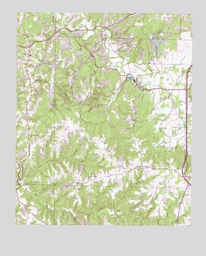
Isbell, AL USGS Topographic Map
Click on map above to begin viewing in our Map Viewer.

This topographic map contains these locations and features:
Feature Name Type Latitude Longitude GNIS ID View Map
Bare Field BranchStreamN34.4295°W87.7545°113467View Map
BelgreenPopulated PlaceN34.4748°W87.8664°154979View Map
Belgreen CemeteryCemeteryN34.4806°W87.8636°136119View Map
Belgreen Census Designated PlaceCensusN34.4768°W87.8653°2628578View Map
Belgreen Fire Protection DistrictBuildingN34.4798°W87.8666°2683149View Map
Belgreen High SchoolSchoolN34.4745°W87.8653°136120View Map
Big BranchStreamN34.3840°W87.8186°114237View Map
Bowen BranchStreamN34.4140°W87.8361°114768View Map
Butler BranchStreamN34.3829°W87.8034°115307View Map
Camp BranchStreamN34.4129°W87.8523°115440View Map
Capeland BranchStreamN34.3929°W87.8595°115600View Map
Cedar Creek ChurchChurchN34.4873°W87.8467°136138View Map
Chisholm CreekStreamN34.4982°W87.8431°116069View Map
Creamos Springs BranchStreamN34.4287°W87.7553°116833View Map
Desprez BranchStreamN34.4651°W87.7703°117241View Map
Duncan BranchStreamN34.4584°W87.7800°117659View Map
Ezzell BranchStreamN34.4707°W87.8484°118097View Map
Franklin CountyCivilN34.4417°W87.8438°161555View Map
Frog Pond Fire DepartmentBuildingN34.4092°W87.7913°2683151View Map
Glasgow CornerPopulated PlaceN34.4370°W87.8675°156409View Map
Graham BranchStreamN34.4732°W87.8098°119209View Map
Graham CemeteryCemeteryN34.4684°W87.8078°119212View Map
Grissom BranchStreamN34.4593°W87.8503°119428View Map
Hamilton BranchStreamN34.4468°W87.8086°119628View Map
Hamilton CemeteryCemeteryN34.4529°W87.8075°119633View Map
Hamilton CreekStreamN34.4679°W87.8014°119636View Map
Hickory Flat ChurchChurchN34.4132°W87.8039°136182View Map
IsbellPopulated PlaceN34.4554°W87.7539°151864View Map
Keelen CemeteryCemeteryN34.4531°W87.7684°136193View Map
Lawler CemeteryCemeteryN34.3962°W87.8314°152002View Map
Long BranchStreamN34.4904°W87.8123°121996View Map
Lucas BranchStreamN34.4562°W87.7795°122097View Map
Mack BranchStreamN34.3987°W87.8720°152193View Map
Madden BranchStreamN34.4776°W87.8106°122187View Map
Martin HollowValleyN34.4576°W87.8492°122329View Map
McWright CemeteryCemeteryN34.4320°W87.7734°152291View Map
McWright CreekStreamN34.4479°W87.7625°122608View Map
Moorman CemeteryCemeteryN34.4009°W87.8231°136208View Map
Mount Hebron CemeteryCemeteryN34.3968°W87.7686°136209View Map
Mount Hebron ChurchChurchN34.3976°W87.7664°123211View Map
Mount Zion CemeteryCemeteryN34.4998°W87.7956°123430View Map
Mud CreekStreamN34.4654°W87.7539°123556View Map
New Friendship CemeteryCemeteryN34.4273°W87.8656°136217View Map
New Friendship ChurchChurchN34.4273°W87.8656°123750View Map
New Pleasant ChurchChurchN34.4295°W87.8328°149513View Map
Nix BranchStreamN34.3762°W87.7781°123952View Map
Old Belgreen CemeteryCemeteryN34.4795°W87.8653°136225View Map
Old Robinson CemeteryCemeteryN34.4518°W87.7675°136230View Map
Parrish BranchStreamN34.4648°W87.7739°124459View Map
Parrish PondLakeN34.4857°W87.7778°124460View Map
Piney CreekStreamN34.4809°W87.8445°152938View Map
Pleasant HillLocaleN34.4009°W87.8214°136247View Map
Pleasant Hill CemeteryCemeteryN34.4034°W87.8175°136248View Map
Pleasant Hill ChurchChurchN34.4032°W87.8175°125013View Map
Pleasant Hill SchoolSchoolN34.4095°W87.7864°125016View Map
Pounders CemeteryCemeteryN34.4362°W87.7920°125216View Map
Pounders HollowValleyN34.4479°W87.8061°125217View Map
Pounders-Quinn CemeteryCemeteryN34.4145°W87.8117°136253View Map
Quinn Memorial ChurchChurchN34.4068°W87.7970°125385View Map
Ray BranchStreamN34.4384°W87.8100°125454View Map
Robinson CreekStreamN34.4595°W87.7811°125726View Map
RockwoodPopulated PlaceN34.4551°W87.7848°125795View Map
Rockwood ChurchChurchN34.4548°W87.7795°136259View Map
Rockwood Junior High SchoolSchoolN34.4545°W87.7806°165606View Map
Rockwood LakeLakeN34.4617°W87.7939°136260View Map
Rockwood SpringSpringN34.4543°W87.7848°149271View Map
Rocky BranchStreamN34.3832°W87.8473°125812View Map
Rocky BranchStreamN34.3998°W87.7884°125813View Map
Sawmill BranchStreamN34.3784°W87.7820°126441View Map
Shingle BranchStreamN34.4487°W87.8070°126766View Map
Smith CemeteryCemeteryN34.4904°W87.8217°136280View Map
Sol Martin BranchStreamN34.4707°W87.8300°127096View Map
Spring HollowValleyN34.4529°W87.8511°127261View Map
Steadham CemeteryCemeteryN34.4476°W87.7742°136289View Map
Steele BranchStreamN34.4468°W87.8528°127340View Map
Steele BranchStreamN34.3812°W87.8178°127341View Map
Stone BranchStreamN34.3820°W87.8039°127429View Map
Strickland BranchStreamN34.3801°W87.8331°127465View Map
Upper Field BranchStreamN34.4123°W87.8264°128373View Map
Walden CemeteryCemeteryN34.4529°W87.8236°128504View Map
Welch CemeteryCemeteryN34.4643°W87.8336°136304View Map
Wingo CemeteryCemeteryN34.4073°W87.7925°136310View Map

Note: Coordinates in the location and feature list above are referenced to NAD83 datum.


Copyright (C) 2008-2025 Ryan Niemi / Sunset Dynamics ... All Rights Reserved