TopoQuest Logo
Do you find TopoQuest useful?
Help keep TopoQuest running and adding new maps/features by donating!
Bitcoin:  19c7KJd3qBynnjoSw5npx9KScwjBe4ifkT
Litecoin:  LXs6TkuXGGXo1vDsWCkWVdjQX94eUKd6ui
Home View Maps Find Maps Find Places Resources & Links


Bull Shoals, Arkansas Topographic Map

USGS Map Title: Bull Shoals, AR
USGS Map MRC: 36092D5
DRG (GeoTIFF) Download: o36092d5.tif


Neighboring USGS Topographic Map Quads:


  Theodosia, MO  
36092E6
 

  Isabella, MO  
36092E5
 

  Gainesville, MO  
36092E4
 

  Cotter NW, AR  
36092D6
 

  Bull Shoals, AR  
36092D5
 

  Midway, AR  
36092D4
 

  Cotter SW, AR  
36092C6
 

  Cotter, AR  
36092C5
 

  Mountain Home West, AR  
36092C4


Map MRC Location:

N37°
W93°
N37°
W92°
H8 H7 H6 H5 H4 H3 H2 H1
G8 G7 G6 G5 G4 G3 G2 G1
F8 F7 F6 F5 F4 F3 F2 F1
E8 E7 E6 E5 E4 E3 E2 E1
D8 D7 D6 D5 D4 D3 D2 D1
C8 C7 C6 C5 C4 C3 C2 C1
B8 B7 B6 B5 B4 B3 B2 B1
A8 A7 A6 A5 A4 A3 A2 A1
N36°
W93°
N36°
W92°

Bull Shoals, AR USGS 1:24K Topographic Map Preview:
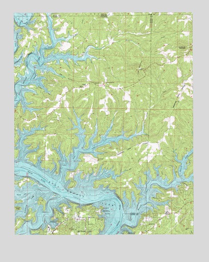
Bull Shoals, AR USGS Topographic Map
Click on map above to begin viewing in our Map Viewer.

This topographic map contains these locations and features:
Feature Name Type Latitude Longitude GNIS ID View Map
Bull HollowValleyN36.4626°W92.6124°47169View Map
Bull ShoalsPopulated PlaceN36.3840°W92.5816°76463View Map
Bull Shoals Police DepartmentBuildingN36.3832°W92.5828°2118860View Map
Bull Shoals Public Use AreaParkN36.3815°W92.5963°47174View Map
Bull Shoals Shopping CenterLocaleN36.3820°W92.5927°61116View Map
Bull Shoals Volunteer Fire Department StationBuildingN36.3843°W92.5813°2116204View Map
Christ by the Lake Lutheran ChurchChurchN36.3778°W92.5835°70052View Map
Dry Run (historical)StreamN36.4131°W92.6229°61056View Map
Grover Township Volunteer Fire DepartmentBuildingN36.3763°W92.5330°2116513View Map
Gunnel ForkStreamN36.4003°W92.6104°49739View Map
Hilltop MissionChurchN36.4587°W92.5774°50136View Map
Horseshoe MountainSummitN36.4803°W92.5029°77234View Map
Howard CreekStreamN36.3823°W92.5493°50363View Map
Lakeview Public Use AreaParkN36.3767°W92.5471°50959View Map
Long MountainSummitN36.4684°W92.5382°58084View Map
Mountain CreekStreamN36.4737°W92.6038°52491View Map
Newton Flat CemeteryCemeteryN36.3826°W92.5646°52764View Map
Noe CreekStreamN36.4087°W92.5513°52788View Map
Oak HollowValleyN36.4692°W92.6121°52935View Map
OaklandPopulated PlaceN36.4609°W92.5710°77888View Map
Oakland - Promise Land Volunteer Fire Department Station 1BuildingN36.4589°W92.5758°2116892View Map
Oakland - Promise Land Volunteer Fire Department Station 2BuildingN36.4263°W92.5368°2116893View Map
Oakland SchoolSchoolN36.4595°W92.5757°52965View Map
Pace Ferry (historical)CrossingN36.4028°W92.6013°61057View Map
Point Return Public Use AreaParkN36.3887°W92.5643°53646View Map
Price ChurchChurchN36.4809°W92.6152°78097View Map
Price PlacePopulated PlaceN36.4945°W92.6066°61052View Map
Price Place CemeteryCemeteryN36.4806°W92.6152°61055View Map
Price Place School (historical)SchoolN36.4892°W92.6074°81919View Map
Promise Land ChurchChurchN36.4167°W92.5668°53809View Map
Promise Land RidgeRidgeN36.4551°W92.5091°53810View Map
Promised Land CemeteryCemeteryN36.4162°W92.5668°61062View Map
Sister CreekStreamN36.4053°W92.5949°54878View Map
Strawberry CreekStreamN36.4001°W92.5996°55269View Map
Township of GroverCivilN36.3797°W92.5305°69560View Map
Township of North Fork (historical)CivilN36.4487°W92.5835°69643View Map
Wolf CreekStreamN36.4842°W92.5963°56481View Map

Note: Coordinates in the location and feature list above are referenced to NAD83 datum.


Copyright (C) 2008-2025 Ryan Niemi / Sunset Dynamics ... All Rights Reserved