TopoQuest Logo
Do you find TopoQuest useful?
Help keep TopoQuest running and adding new maps/features by donating!
Bitcoin:  19c7KJd3qBynnjoSw5npx9KScwjBe4ifkT
Litecoin:  LXs6TkuXGGXo1vDsWCkWVdjQX94eUKd6ui
Home View Maps Find Maps Find Places Resources & Links


Isabella, Missouri Topographic Map

USGS Map Title: Isabella, MO
USGS Map MRC: 36092E5
DRG (GeoTIFF) Download: o36092e5.tif


Neighboring USGS Topographic Map Quads:


  Thornfield, MO  
36092F6
 

  Willhoit, MO  
36092F5
 

  Gainesville NW, MO  
36092F4
 

  Theodosia, MO  
36092E6
 

  Isabella, MO  
36092E5
 

  Gainesville, MO  
36092E4
 

  Cotter NW, AR  
36092D6
 

  Bull Shoals, AR  
36092D5
 

  Midway, AR  
36092D4


Map MRC Location:

N37°
W93°
N37°
W92°
H8 H7 H6 H5 H4 H3 H2 H1
G8 G7 G6 G5 G4 G3 G2 G1
F8 F7 F6 F5 F4 F3 F2 F1
E8 E7 E6 E5 E4 E3 E2 E1
D8 D7 D6 D5 D4 D3 D2 D1
C8 C7 C6 C5 C4 C3 C2 C1
B8 B7 B6 B5 B4 B3 B2 B1
A8 A7 A6 A5 A4 A3 A2 A1
N36°
W93°
N36°
W92°

Isabella, MO USGS 1:24K Topographic Map Preview:
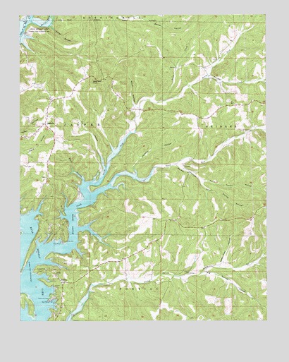
Isabella, MO USGS Topographic Map
Click on map above to begin viewing in our Map Viewer.

This topographic map contains these locations and features:
Feature Name Type Latitude Longitude GNIS ID View Map
Barren ForkStreamN36.6203°W92.6218°748685View Map
Big Spring HollowValleyN36.5201°W92.5321°748851View Map
Bratten Spring CreekStreamN36.5192°W92.6221°748999View Map
Burse Ford (historical)CrossingN36.5059°W92.6138°734295View Map
Charity CemeteryCemeteryN36.5198°W92.5396°749331View Map
Charity School (historical)SchoolN36.5162°W92.5413°733837View Map
DilliaPopulated PlaceN36.6209°W92.6093°740430View Map
Dover HollowValleyN36.5867°W92.5649°749693View Map
Elm HollowValleyN36.5631°W92.5821°749828View Map
Freeman CreekStreamN36.5992°W92.5310°749994View Map
Friend CemeteryCemeteryN36.5964°W92.6160°750001View Map
Gate Post HollowValleyN36.5231°W92.5232°750031View Map
Idumea SchoolSchoolN36.5695°W92.5732°734292View Map
IsabellaPopulated PlaceN36.5809°W92.6127°750470View Map
Isabella CemeteryCemeteryN36.5828°W92.6118°1829037View Map
Isabella Post OfficePost OfficeN36.5837°W92.6108°1829038View Map
Isabella Volunteer Fire StationBuildingN36.5803°W92.6127°2620818View Map
Jackson HollowValleyN36.5598°W92.5666°750483View Map
Kelton HollowValleyN36.6209°W92.6099°750584View Map
Little CreekStreamN36.5902°W92.5537°750756View Map
LocustPopulated PlaceN36.5637°W92.5424°750811View Map
Locust School (historical)SchoolN36.5640°W92.5416°733836View Map
Nave Ford (historical)CrossingN36.5137°W92.6160°734294View Map
North Fork Bratten Spring CreekStreamN36.5512°W92.5899°751332View Map
North Pocket HollowValleyN36.5570°W92.5329°751353View Map
Pleasant Grove School (historical)SchoolN36.6034°W92.5329°733835View Map
Pocket HollowValleyN36.5640°W92.5463°751682View Map
PontiacPopulated PlaceN36.5156°W92.6038°751705View Map
Pontiac / Price Place Volunteer Fire DepartmentBuildingN36.5024°W92.6063°2620315View Map
Pontiac Census Designated PlaceCensusN36.5166°W92.6036°2587106View Map
Pontiac ChurchChurchN36.5195°W92.6071°751707View Map
Pontiac Public Use AreaParkN36.5101°W92.6082°753125View Map
Shop HollowValleyN36.5570°W92.5929°752137View Map
South Fork Bratten Spring CreekStreamN36.5512°W92.5899°752253View Map
South Pocket HollowValleyN36.5570°W92.5329°752269View Map
Spring Creek Public Use AreaParkN36.5362°W92.6132°753124View Map
Timber Knob Volunteer Fire DepartmentBuildingN36.5324°W92.5591°2620410View Map
Township of JasperCivilN36.5774°W92.5998°767129View Map
Township of PontiacCivilN36.5167°W92.5516°767135View Map
Turnbull CemeteryCemeteryN36.5214°W92.6121°752620View Map
Turnbull Cemetery (historical)CemeteryN36.5176°W92.6229°734293View Map
Upton CemeteryCemeteryN36.5778°W92.5093°752681View Map
Wilkinson KnobSummitN36.5987°W92.5882°752906View Map
Wolf CemeteryCemeteryN36.5639°W92.6224°752947View Map

Note: Coordinates in the location and feature list above are referenced to NAD83 datum.


Copyright (C) 2008-2024 Ryan Niemi / Sunset Dynamics ... All Rights Reserved