TopoQuest Logo
Do you find TopoQuest useful?
Help keep TopoQuest running and adding new maps/features by donating!
Bitcoin:  19c7KJd3qBynnjoSw5npx9KScwjBe4ifkT
Litecoin:  LXs6TkuXGGXo1vDsWCkWVdjQX94eUKd6ui
Home View Maps Find Maps Find Places Resources & Links


Garfield, Kentucky Topographic Map

USGS Map Title: Garfield, KY
USGS Map MRC: 37086G3
DRG (GeoTIFF) Download: o37086g3.tif


Neighboring USGS Topographic Map Quads:


  Lodiburg, KY  
37086H4
 

  Irvington, KY  
37086H3
 

  Guston, KY  
37086H2
 

  Hardinsburg, KY  
37086G4
 

  Garfield, KY  
37086G3
 

  Big Spring, KY  
37086G2
 

  Kingswood, KY  
37086F4
 

  Custer, KY  
37086F3
 

  Constantine, KY  
37086F2


Map MRC Location:

N38°
W87°
N38°
W86°
H8 H7 H6 H5 H4 H3 H2 H1
G8 G7 G6 G5 G4 G3 G2 G1
F8 F7 F6 F5 F4 F3 F2 F1
E8 E7 E6 E5 E4 E3 E2 E1
D8 D7 D6 D5 D4 D3 D2 D1
C8 C7 C6 C5 C4 C3 C2 C1
B8 B7 B6 B5 B4 B3 B2 B1
A8 A7 A6 A5 A4 A3 A2 A1
N37°
W87°
N37°
W86°

Garfield, KY USGS 1:24K Topographic Map Preview:
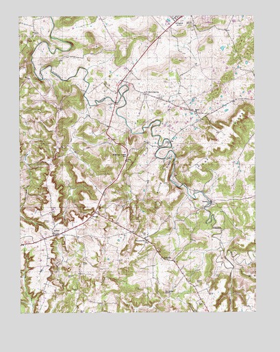
Garfield, KY USGS Topographic Map
Click on map above to begin viewing in our Map Viewer.

This topographic map contains these locations and features:
Feature Name Type Latitude Longitude GNIS ID View Map
Basin SpringPopulated PlaceN37.8420°W86.3066°507459View Map
Bethel ChurchChurchN37.8342°W86.2821°486984View Map
Blue ForkStreamN37.7684°W86.2625°487511View Map
Board CemeteryCemeteryN37.7539°W86.2797°487573View Map
Bruner CemeteryCemeteryN37.7703°W86.3397°488059View Map
Cedar Hill CemeteryCemeteryN37.8714°W86.2827°489217View Map
Dents BridgeBridgeN37.8215°W86.2944°490822View Map
GarfieldPopulated PlaceN37.7828°W86.3575°492703View Map
GraysvillePopulated PlaceN37.7723°W86.2975°508124View Map
Haynes CemeteryCemeteryN37.7720°W86.3230°493922View Map
HensleyPopulated PlaceN37.7920°W86.3350°508223View Map
High Burning RidgeRidgeN37.8020°W86.2969°494179View Map
Horseley CemeteryCemeteryN37.7598°W86.3447°494593View Map
Hurricane HollowValleyN37.8189°W86.3694°494841View Map
Johnson CemeteryCemeteryN37.7887°W86.3591°495387View Map
Lost RunStreamN37.7803°W86.3664°497198View Map
Marr CemeteryCemeteryN37.7600°W86.3114°497557View Map
Pilot RidgeRidgeN37.8209°W86.2672°500652View Map
RosettaPopulated PlaceN37.7967°W86.2730°508975View Map
Shumate CemeteryCemeteryN37.7623°W86.2814°503475View Map
Sinking Creek HillSummitN37.8165°W86.3164°503565View Map
Somerset KnobSummitN37.7584°W86.2994°503877View Map
StinnettsvillePopulated PlaceN37.7809°W86.3086°509133View Map
Stony ForkStreamN37.7684°W86.2625°504507View Map
Turpin CemeteryCemeteryN37.7648°W86.2714°505682View Map
Whitworth CemeteryCemeteryN37.7653°W86.3500°506704View Map
Woods CemeteryCemeteryN37.7503°W86.3433°507116View Map

Note: Coordinates in the location and feature list above are referenced to NAD83 datum.


Copyright (C) 2008-2025 Ryan Niemi / Sunset Dynamics ... All Rights Reserved