TopoQuest Logo
Do you find TopoQuest useful?
Help keep TopoQuest running and adding new maps/features by donating!
Bitcoin:  19c7KJd3qBynnjoSw5npx9KScwjBe4ifkT
Litecoin:  LXs6TkuXGGXo1vDsWCkWVdjQX94eUKd6ui
Home View Maps Find Maps Find Places Resources & Links


Gaylord, Minnesota Topographic Map

USGS Map Title: Gaylord, MN
USGS Map MRC: 44094E2
DRG (GeoTIFF) Download: o44094e2.tif


Neighboring USGS Topographic Map Quads:


  Brownton, MN  
44094F3
 

  New Auburn, MN  
44094F2
 

  Green Isle, MN  
44094F1
 

  Winthrop, MN  
44094E3
 

  Gaylord, MN  
44094E2
 

  Arlington, MN  
44094E1
 

  Bernadotte, MN  
44094D3
 

  New Sweden, MN  
44094D2
 

  Norseland, MN  
44094D1


Map MRC Location:

N45°
W95°
N45°
W94°
H8 H7 H6 H5 H4 H3 H2 H1
G8 G7 G6 G5 G4 G3 G2 G1
F8 F7 F6 F5 F4 F3 F2 F1
E8 E7 E6 E5 E4 E3 E2 E1
D8 D7 D6 D5 D4 D3 D2 D1
C8 C7 C6 C5 C4 C3 C2 C1
B8 B7 B6 B5 B4 B3 B2 B1
A8 A7 A6 A5 A4 A3 A2 A1
N44°
W95°
N44°
W94°

Gaylord, MN USGS 1:24K Topographic Map Preview:
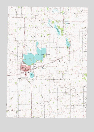
Gaylord, MN USGS Topographic Map
Click on map above to begin viewing in our Map Viewer.

This topographic map contains these locations and features:
Feature Name Type Latitude Longitude GNIS ID View Map
Altnow CemeteryCemeteryN44.5861°W94.1717°2065084View Map
Altnow LakeLakeN44.5987°W94.1720°639310View Map
Altnow Marsh State Wildlife Management AreaParkN44.6055°W94.1836°1817674View Map
American Lutheran ChurchChurchN44.5614°W94.2272°2065161View Map
Assembly of God ChurchChurchN44.5531°W94.2203°2065162View Map
Beatty CemeteryCemeteryN44.5794°W94.1536°639794View Map
Beatty LakeLakeN44.5849°W94.1567°639795View Map
City of GaylordCivilN44.5555°W94.2124°2394868View Map
County Ditch Number EightCanalN44.6222°W94.1258°1817682View Map
County Ditch Number FiftyfiveCanalN44.5344°W94.1569°1817675View Map
County Ditch Number FortyCanalN44.5658°W94.2497°1817672View Map
County Ditch Number FortythreeCanalN44.5105°W94.1789°642095View Map
County Ditch Number SixtyoneCanalN44.6166°W94.2086°1817734View Map
Duff LakeSwampN44.6202°W94.1789°642966View Map
Gasow CemeteryCemeteryN44.5530°W94.1541°644057View Map
GaylordPopulated PlaceN44.5530°W94.2205°644060View Map
GaylordLocaleN44.5514°W94.2189°2065156View Map
Gaylord City HallBuildingN44.5533°W94.2214°2065153View Map
Gaylord City LibraryBuildingN44.5542°W94.2125°2065152View Map
Gaylord ClinicHospitalN44.5497°W94.2208°2065163View Map
Gaylord Fire DepartmentBuildingN44.5548°W94.2110°2666610View Map
Gaylord Junior High SchoolSchoolN44.5561°W94.2222°2065168View Map
Gaylord Lakeview HomeHospitalN44.5589°W94.2181°2065164View Map
Gaylord Mobile Home ParkPopulated PlaceN44.5608°W94.2069°2065165View Map
Gaylord Police DepartmentBuildingN44.5554°W94.2109°2065154View Map
Gaylord Post OfficePost OfficeN44.5529°W94.2194°2065155View Map
Immanuel Lutheran ChurchChurchN44.5553°W94.2214°2065160View Map
Immanuel Lutheran SchoolSchoolN44.5539°W94.2211°2065167View Map
Mud LakeLakeN44.5474°W94.2114°648208View Map
Municipal CemeteryCemeteryN44.5436°W94.2272°1817673View Map
Saint John's CemeteryCemeteryN44.5622°W94.2250°2065083View Map
Saint Michael's Catholic ChurchChurchN44.5547°W94.2194°2065159View Map
Saint Paul's Lutheran ChurchChurchN44.5528°W94.2225°2065157View Map
Saint Pauls CemeteryCemeteryN44.5438°W94.2252°650976View Map
Sibley CountyCivilN44.5795°W94.2321°659516View Map
Sibley County CourthouseBuildingN44.5561°W94.2203°2065166View Map
Sibley County SheriffBuildingN44.5564°W94.2202°2065073View Map
Titlow LakeLakeN44.5687°W94.2076°653216View Map
Titlow Lake DamDamN44.5716°W94.1903°1776071View Map
Township of DrydenCivilN44.5884°W94.1928°664002View Map
United Church of ChristChurchN44.5497°W94.2200°2065158View Map
Weimann LakeLakeN44.6066°W94.1581°653894View Map

Note: Coordinates in the location and feature list above are referenced to NAD83 datum.


Copyright (C) 2008-2024 Ryan Niemi / Sunset Dynamics ... All Rights Reserved