TopoQuest Logo
Do you find TopoQuest useful?
Help keep TopoQuest running and adding new maps/features by donating!
Bitcoin:  19c7KJd3qBynnjoSw5npx9KScwjBe4ifkT
Litecoin:  LXs6TkuXGGXo1vDsWCkWVdjQX94eUKd6ui
Home View Maps Find Maps Find Places Resources & Links


Gilboa, West Virginia Topographic Map

USGS Map Title: Gilboa, WV
USGS Map MRC: 38080C8
DRG (GeoTIFF) Download: o38080c8.tif


Neighboring USGS Topographic Map Quads:


  Clay, WV  
38081D1
 

  Swandale, WV  
38080D8
 

  Widen, WV  
38080D7
 

  Lockwood, WV  
38081C1
 

  Gilboa, WV  
38080C8
 

  Summersville, WV  
38080C7
 

  Ansted, WV  
38081B1
 

  Summersville Dam, WV  
38080B8
 

  Mount Nebo, WV  
38080B7


Map MRC Location:

N39°
W81°
N39°
W80°
H8 H7 H6 H5 H4 H3 H2 H1
G8 G7 G6 G5 G4 G3 G2 G1
F8 F7 F6 F5 F4 F3 F2 F1
E8 E7 E6 E5 E4 E3 E2 E1
D8 D7 D6 D5 D4 D3 D2 D1
C8 C7 C6 C5 C4 C3 C2 C1
B8 B7 B6 B5 B4 B3 B2 B1
A8 A7 A6 A5 A4 A3 A2 A1
N38°
W81°
N38°
W80°

Gilboa, WV USGS 1:24K Topographic Map Preview:
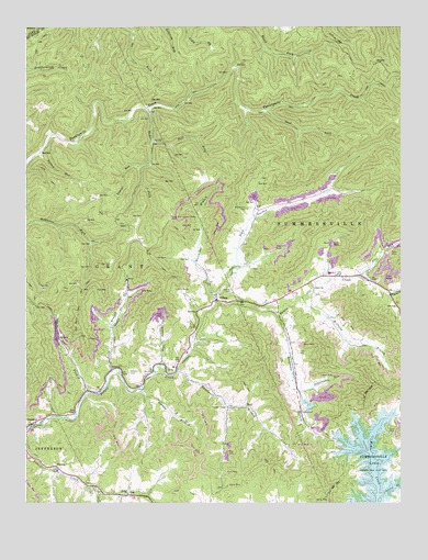
Gilboa, WV USGS Topographic Map
Click on map above to begin viewing in our Map Viewer.

This topographic map contains these locations and features:
Feature Name Type Latitude Longitude GNIS ID View Map
Bell School (historical)SchoolN38.2784°W80.9595°1741051View Map
Bethel CemeteryCemeteryN38.2520°W80.9601°1741052View Map
Bethel United Methodist ChurchChurchN38.2523°W80.9662°1535694View Map
Bryant BranchStreamN38.3051°W80.8793°1536529View Map
Buck Garden CreekStreamN38.3026°W80.9379°1536557View Map
BurlPopulated PlaceN38.2754°W80.9262°1554031View Map
Church of GodChurchN38.3009°W80.9415°1741066View Map
CorneliaPopulated PlaceN38.2826°W80.9101°1741065View Map
Deal ForkStreamN38.3534°W80.9201°1538093View Map
DrennenPopulated PlaceN38.2707°W80.9982°1538315View Map
Drennen Post OfficePost OfficeN38.2708°W80.9977°1741074View Map
Duling CemeteryCemeteryN38.3057°W80.9318°1538417View Map
EnonPopulated PlaceN38.3096°W80.8968°1538723View Map
Enon ChurchChurchN38.3065°W80.9037°1538725View Map
GilboaPopulated PlaceN38.3034°W80.9365°1539393View Map
Gilboa Post OfficePost OfficeN38.3030°W80.9353°1741082View Map
Gilboa United Methodist ChurchChurchN38.3048°W80.9368°1741083View Map
Grant DistrictCivilN38.2861°W80.9601°1928279View Map
HarrietPopulated PlaceN38.3418°W80.9957°1554656View Map
Hutchison BranchStreamN38.3037°W80.9376°1540641View Map
Jerry ForkStreamN38.2793°W80.9793°1540874View Map
Jones BranchStreamN38.2846°W80.9718°1541003View Map
Keenan BranchStreamN38.2798°W80.9612°1541098View Map
Keenan CemeteryCemeteryN38.2843°W80.9657°1541099View Map
Laurel RunStreamN38.3384°W80.9612°1541493View Map
Lone Star Lookout TowerTowerN38.3248°W80.9515°1557860View Map
Lone Star School (historical)SchoolN38.3229°W80.9645°1741090View Map
McClung BranchStreamN38.3029°W80.9076°1542939View Map
McCutchin CemeteryCemeteryN38.3273°W80.9265°1542982View Map
Neff ForkStreamN38.3457°W80.9579°1544079View Map
Peerless Eagle DamDamN38.2751°W80.9065°1559186View Map
Pierson United Methodist ChurchChurchN38.2751°W80.9326°1544809View Map
Pine RunStreamN38.3096°W80.8887°1544903View Map
PoePopulated PlaceN38.2521°W80.9659°1545085View Map
Poe Post OfficePost OfficeN38.2523°W80.9651°1741105View Map
Rader ForkStreamN38.3534°W80.9601°1545375View Map
Rays BranchStreamN38.2862°W80.9562°1545437View Map
Rockcamp BranchStreamN38.2998°W80.9162°1545937View Map
Salem ChurchChurchN38.2854°W80.9715°1546285View Map
Spruce RunStreamN38.3426°W80.9954°1547267View Map
Stony BranchStreamN38.2521°W80.8818°1547491View Map
Sugarcamp RunStreamN38.2793°W80.9090°1547681View Map
Summersville DistrictCivilN38.3179°W80.8856°1928376View Map
Summersville Lake State Wildlife AreaParkN38.2676°W80.8879°1984829View Map
TiptonPopulated PlaceN38.2590°W80.9890°1548105View Map
Water Supply ReservoirReservoirN38.2754°W80.9052°1559187View Map
Way Back TrailTrailN38.2990°W80.9826°1548845View Map
Whitewater BranchStreamN38.2843°W80.9498°1549104View Map
Winebrenner School (historical)SchoolN38.2807°W80.9745°1741128View Map
ZelaPopulated PlaceN38.2859°W80.9498°1549483View Map
Zela Elementary SchoolSchoolN38.2851°W80.9509°1741130View Map

Note: Coordinates in the location and feature list above are referenced to NAD83 datum.


Copyright (C) 2008-2024 Ryan Niemi / Sunset Dynamics ... All Rights Reserved