TopoQuest Logo
Do you find TopoQuest useful?
Help keep TopoQuest running and adding new maps/features by donating!
Bitcoin:  19c7KJd3qBynnjoSw5npx9KScwjBe4ifkT
Litecoin:  LXs6TkuXGGXo1vDsWCkWVdjQX94eUKd6ui
Home View Maps Find Maps Find Places Resources & Links


Clay, West Virginia Topographic Map

USGS Map Title: Clay, WV
USGS Map MRC: 38081D1
DRG (GeoTIFF) Download: o38081d1.tif


Neighboring USGS Topographic Map Quads:


  Newton, WV  
38081E2
 

  Ivydale, WV  
38081E1
 

  Strange Creek, WV  
38080E8
 

  Elkhurst, WV  
38081D2
 

  Clay, WV  
38081D1
 

  Swandale, WV  
38080D8
 

  Bentree, WV  
38081C2
 

  Lockwood, WV  
38081C1
 

  Gilboa, WV  
38080C8


Map MRC Location:

N39°
W82°
N39°
W81°
H8 H7 H6 H5 H4 H3 H2 H1
G8 G7 G6 G5 G4 G3 G2 G1
F8 F7 F6 F5 F4 F3 F2 F1
E8 E7 E6 E5 E4 E3 E2 E1
D8 D7 D6 D5 D4 D3 D2 D1
C8 C7 C6 C5 C4 C3 C2 C1
B8 B7 B6 B5 B4 B3 B2 B1
A8 A7 A6 A5 A4 A3 A2 A1
N38°
W82°
N38°
W81°

Clay, WV USGS 1:24K Topographic Map Preview:
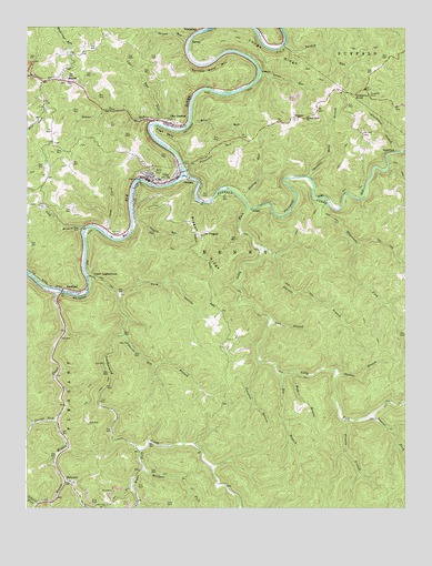
Clay, WV USGS Topographic Map
Click on map above to begin viewing in our Map Viewer.

This topographic map contains these locations and features:
Feature Name Type Latitude Longitude GNIS ID View Map
AvocaPopulated PlaceN38.4532°W81.0507°1553768View Map
Bens RunStreamN38.4754°W81.0712°1535645View Map
BickmorePopulated PlaceN38.3815°W81.1121°1535764View Map
Bickmore Post OfficePost OfficeN38.3818°W81.1113°1741266View Map
Bickmore School (historical)SchoolN38.3823°W81.1118°1741267View Map
Big BranchStreamN38.4101°W81.0412°1535800View Map
Buffalo CreekStreamN38.4615°W81.0729°1536631View Map
Buffalo Valley Baptist ChurchChurchN38.4762°W81.0329°1536660View Map
Bullpen ForkStreamN38.3857°W81.0868°1536712View Map
Camp CreekStreamN38.4462°W81.0987°1536911View Map
Campbell BranchStreamN38.4132°W81.0482°1536969View Map
Cannel Coal HollowValleyN38.3759°W81.0871°1537003View Map
Carver ForkStreamN38.3982°W81.1151°1537078View Map
Chestnut KnobSummitN38.4815°W81.0173°1554125View Map
Chestnut Knob BranchStreamN38.4609°W81.0321°1537283View Map
ClayPopulated PlaceN38.4604°W81.0851°1537360View Map
Clay Christian AcademySchoolN38.4710°W81.0495°1741381View Map
Clay Community ChurchChurchN38.4584°W81.0890°1741382View Map
Clay CountyCivilN38.4625°W81.0751°1550014View Map
Clay County CourthouseBuildingN38.4604°W81.0764°2727830View Map
Clay County Elementary SchoolSchoolN38.4610°W81.0840°1741386View Map
Clay County Emergency Ambulance Service Station 100BuildingN38.4594°W81.0793°2581035View Map
Clay County High SchoolSchoolN38.4461°W81.0925°1741384View Map
Clay County Middle SchoolSchoolN38.4604°W81.0816°1741389View Map
Clay County Public LibraryBuildingN38.4603°W81.0765°2727199View Map
Clay County Sheriff's OfficeBuildingN38.4602°W81.0833°2727900View Map
Clay Courthouse StationLocaleN38.4584°W81.0893°1741385View Map
Clay First Baptist ChurchChurchN38.4612°W81.0848°1741387View Map
Clay JunctionPopulated PlaceN38.4748°W81.0776°1554140View Map
Clay Methodist ChurchChurchN38.4526°W81.0901°1741388View Map
Clay Post OfficePost OfficeN38.4608°W81.0865°1741390View Map
Clay Volunteer Fire DepartmentBuildingN38.4605°W81.0836°2577686View Map
Cove HollowValleyN38.4309°W81.0934°1537726View Map
Cove Hollow School (historical)SchoolN38.4173°W81.0601°1741283View Map
Devils Den BranchStreamN38.4198°W81.0929°1538159View Map
District BCivilN38.4401°W81.0221°1928246View Map
DundonPopulated PlaceN38.4598°W81.0687°1554337View Map
Dundon BridgeBridgeN38.4626°W81.0737°1741395View Map
Eagle BendBendN38.4723°W81.0801°1538485View Map
Elkview Schoolhouse (historical)SchoolN38.4759°W81.0782°1741398View Map
Fairview Baptist ChurchChurchN38.4754°W81.0787°1741401View Map
Fitzwater RunStreamN38.4623°W81.0729°1539017View Map
Franks BranchStreamN38.3751°W81.0140°1539233View Map
Grassy RunStreamN38.4559°W81.0537°1539636View Map
Greathouse BranchStreamN38.4673°W81.0037°1539660View Map
Hammocks ForkStreamN38.4545°W81.0257°1539885View Map
HartlandPopulated PlaceN38.4320°W81.1126°1554658View Map
Hartland BridgeBridgeN38.4315°W81.1132°2635375View Map
Herman Nelson SpringSpringN38.4679°W81.0554°1677972View Map
Jamestown (historical)Populated PlaceN38.4562°W81.0293°1741411View Map
King CemeteryCemeteryN38.4700°W81.1155°2586243View Map
Laurel ForkStreamN38.3993°W81.0107°1541459View Map
Leatherwood CreekStreamN38.4351°W81.1046°1541593View Map
Lick BranchStreamN38.4240°W81.0446°1541861View Map
Lick BranchStreamN38.4470°W81.1062°1541863View Map
Lick BranchStreamN38.3818°W81.1126°1541876View Map
Lilly ForkStreamN38.4529°W81.0518°1541961View Map
Longs RidgeRidgeN38.4920°W81.0457°1542437View Map
Longs RunStreamN38.4879°W81.0482°1542438View Map
Lower Two RunStreamN38.4751°W81.0837°1542586View Map
MayselPopulated PlaceN38.4859°W81.1126°1542915View Map
Maysel Missionary Baptist ChurchChurchN38.4859°W81.1146°1741327View Map
Maysel Post OfficePost OfficeN38.4862°W81.1122°1741328View Map
Maysel School (historical)SchoolN38.4876°W81.1140°1741329View Map
Middle CreekStreamN38.4318°W81.1151°1543161View Map
Morocco (historical)Populated PlaceN38.4312°W81.0943°1741332View Map
Mount PisgahSummitN38.4462°W81.0665°1544961View Map
Nathan BranchStreamN38.4109°W81.0234°1544053View Map
New Dundon BridgeBridgeN38.4633°W81.0731°2635376View Map
OaktonPopulated PlaceN38.4879°W81.0473°1555256View Map
Osborne ForkStreamN38.3759°W81.1215°1544453View Map
Pisgah RidgeRidgeN38.4423°W81.0684°1544959View Map
Pisgah RunStreamN38.4495°W81.0898°1544960View Map
Reed-Stephenson-Pierson CemeteryCemeteryN38.4651°W81.0868°1741419View Map
Right Fork Leatherwood CreekStreamN38.3901°W81.0876°1545661View Map
Sand ForkPopulated PlaceN38.4673°W81.0059°1555559View Map
Sinnett BranchStreamN38.4423°W81.0465°1546837View Map
SpreadPopulated PlaceN38.4959°W81.0707°1555686View Map
Spread Bend MountainSummitN38.4876°W81.0698°1555687View Map
Town of ClayCivilN38.4617°W81.0849°2390798View Map
TriplettPopulated PlaceN38.4765°W81.0359°1555824View Map
Triplett CemeteryCemeteryN38.4756°W81.0368°1741427View Map
Triplett School (historical)SchoolN38.4757°W81.0359°1741428View Map
Turkey RunStreamN38.4954°W81.0398°1548352View Map
Two RunPopulated PlaceN38.4759°W81.0837°1741429View Map
Upper LeatherwoodPopulated PlaceN38.4354°W81.1037°1549964View Map
Upper Two RunStreamN38.4748°W81.0818°1548566View Map
Webb BranchStreamN38.4104°W81.0368°1548862View Map
Woods CemeteryCemeteryN38.4190°W81.0570°1741376View Map

Note: Coordinates in the location and feature list above are referenced to NAD83 datum.


Copyright (C) 2008-2024 Ryan Niemi / Sunset Dynamics ... All Rights Reserved