TopoQuest Logo
Do you find TopoQuest useful?
Help keep TopoQuest running and adding new maps/features by donating!
Bitcoin:  19c7KJd3qBynnjoSw5npx9KScwjBe4ifkT
Litecoin:  LXs6TkuXGGXo1vDsWCkWVdjQX94eUKd6ui
Home View Maps Find Maps Find Places Resources & Links


Summersville Dam, West Virginia Topographic Map

USGS Map Title: Summersville Dam, WV
USGS Map MRC: 38080B8
DRG (GeoTIFF) Download: o38080b8.tif


Neighboring USGS Topographic Map Quads:


  Lockwood, WV  
38081C1
 

  Gilboa, WV  
38080C8
 

  Summersville, WV  
38080C7
 

  Ansted, WV  
38081B1
 

  Summersville Dam, WV  
38080B8
 

  Mount Nebo, WV  
38080B7
 

  Fayetteville, WV  
38081A1
 

  Winona, WV  
38080A8
 

  Corliss, WV  
38080A7


Map MRC Location:

N39°
W81°
N39°
W80°
H8 H7 H6 H5 H4 H3 H2 H1
G8 G7 G6 G5 G4 G3 G2 G1
F8 F7 F6 F5 F4 F3 F2 F1
E8 E7 E6 E5 E4 E3 E2 E1
D8 D7 D6 D5 D4 D3 D2 D1
C8 C7 C6 C5 C4 C3 C2 C1
B8 B7 B6 B5 B4 B3 B2 B1
A8 A7 A6 A5 A4 A3 A2 A1
N38°
W81°
N38°
W80°

Summersville Dam, WV USGS 1:24K Topographic Map Preview:
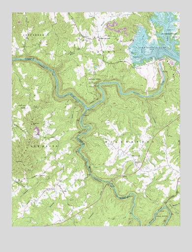
Summersville Dam, WV USGS Topographic Map
Click on map above to begin viewing in our Map Viewer.

This topographic map contains these locations and features:
Feature Name Type Latitude Longitude GNIS ID View Map
Anglins CreekStreamN38.1368°W80.8859°1550107View Map
Arrowwood CreekStreamN38.1512°W80.9312°1535026View Map
Backus School (historical)SchoolN38.2307°W80.9834°1557065View Map
Battle RunStreamN38.2248°W80.8926°1535311View Map
Bell School (historical)SchoolN38.1593°W80.8912°1557068View Map
Camp Gauley (historical)MilitaryN38.2019°W80.9394°1557073View Map
Carnifex Ferry (historical)CrossingN38.1937°W80.9434°1557074View Map
Carnifex Ferry Battlefield State ParkParkN38.2090°W80.9395°1537045View Map
Carnifex School (historical)SchoolN38.1918°W80.9684°1556062View Map
Carnifex TrailTrailN38.1998°W80.9354°1537046View Map
Carnifex TunnelTunnelN38.1812°W80.9479°1537047View Map
CliftyPopulated PlaceN38.1457°W80.9620°1554153View Map
Clifty ChurchChurchN38.1512°W80.9643°1537409View Map
Collison CreekStreamN38.2004°W80.9004°1537537View Map
Copenhaver School (historical)SchoolN38.2284°W80.9037°1557076View Map
DeegansPopulated PlaceN38.1529°W80.9457°1556071View Map
Dogwood CreekStreamN38.1696°W80.9504°1538248View Map
Dogwood RidgeRidgeN38.1619°W80.9975°1538251View Map
Dotson-Simpson CemeteryCemeteryN38.2334°W80.9429°1538285View Map
Elliot (historical)Populated PlaceN38.1793°W80.9893°1556081View Map
Emanuel HillSummitN38.1848°W80.9843°1554398View Map
Gad (historical)Populated PlaceN38.2412°W80.8841°2784486View Map
Glade CreekStreamN38.1304°W80.9090°1539423View Map
Hedricks CreekStreamN38.1551°W80.9415°1540125View Map
Insignificant RapidsRapidsN38.2029°W80.9123°1877631View Map
Iron Ring RapidsRapidsN38.2015°W80.9598°1877629View Map
JenkyPopulated PlaceN38.1496°W80.9948°1556128View Map
Keslers Cross LanesPopulated PlaceN38.2354°W80.9357°1541166View Map
Keslers Cross Lanes Post OfficePost OfficeN38.2302°W80.9333°1741178View Map
Keslers Memorial ChurchChurchN38.1468°W80.9682°1541167View Map
Kessler School (historical)SchoolN38.2337°W80.9354°1741179View Map
Kesslers Cross Lane Volunteer Fire DepartmentBuildingN38.2336°W80.9352°2577534View Map
Kevin Ritchie Memorial BridgeBridgeN38.1507°W80.9271°2635391View Map
Koontz School (historical)SchoolN38.1757°W80.9665°1556133View Map
Legg CemeteryCemeteryN38.1523°W80.9891°2586290View Map
Legg School (historical)SchoolN38.1512°W80.9937°1541774View Map
Lost Paddle RapidsRapidsN38.1965°W80.9470°1877628View Map
McClungs MeadowsFlatN38.2418°W80.9337°1741186View Map
McKee CreekStreamN38.2265°W80.8823°1543016View Map
Meadow CreekStreamN38.1365°W80.8804°1543058View Map
Meadow CreekStreamN38.2154°W80.9687°1543059View Map
Meadow Creek School (historical)SchoolN38.2229°W80.9315°1557088View Map
Meadow RiverStreamN38.1934°W80.9445°1552050View Map
Mill CreekStreamN38.1340°W80.9109°1543310View Map
Morrison (historical)Populated PlaceN38.2254°W80.9045°1741188View Map
Mount LookoutPopulated PlaceN38.1668°W80.9118°1555171View Map
Mount Lookout CemeteryCemeteryN38.1618°W80.9090°1741190View Map
Mount Lookout Post OfficePost OfficeN38.1643°W80.9088°1741191View Map
Mount Pleasant ChurchChurchN38.1621°W80.9087°1543742View Map
New Milton School (historical)SchoolN38.1665°W80.9132°1741198View Map
Nicholas GapGapN38.1782°W80.9857°1556159View Map
Oak Grove School (historical)SchoolN38.1537°W80.9179°1557091View Map
Old Carnifex Ferry SiteLocaleN38.1937°W80.9432°1544348View Map
Panther MountainSummitN38.2448°W80.9990°1741208View Map
Pillow Rock RapidsRapidsN38.2057°W80.9348°1877627View Map
Pine Bluff School (historical)SchoolN38.1343°W80.9554°1556174View Map
Pine Grove School (historical)SchoolN38.1804°W80.9012°1557095View Map
Richmond ChapelChurchN38.1957°W80.9893°1545562View Map
Rucker BendBendN38.2154°W80.8804°1546133View Map
Shady Grove ChurchChurchN38.1546°W80.9793°1546595View Map
Shawver Bridge (historical)BridgeN38.1534°W80.9387°1556196View Map
Sparks (historical)Populated PlaceN38.2357°W80.9026°1557098View Map
Staton BranchStreamN38.1982°W80.9498°1547357View Map
Stickler RunStreamN38.1390°W80.8843°1547413View Map
Summersville DamDamN38.2223°W80.8907°1547740View Map
Sunday Road School (historical)SchoolN38.1279°W80.9984°1556204View Map
Sweet Falls RapidsRapidsN38.2140°W80.9687°1877630View Map
Tucker ForkStreamN38.1471°W80.9879°1548302View Map
Vinton (historical)Populated PlaceN38.2276°W80.9932°1557106View Map
White CemeteryCemeteryN38.1653°W80.9658°2586209View Map
White School (historical)SchoolN38.2051°W80.9884°1556215View Map
Wilderness Volunteer Fire DepartmentBuildingN38.1577°W80.9031°2577722View Map
Zoar CemeteryCemeteryN38.2351°W80.9395°1741238View Map
Zoar ChurchChurchN38.2348°W80.9395°1549502View Map

Note: Coordinates in the location and feature list above are referenced to NAD83 datum.


Copyright (C) 2008-2025 Ryan Niemi / Sunset Dynamics ... All Rights Reserved