TopoQuest Logo
Do you find TopoQuest useful?
Help keep TopoQuest running and adding new maps/features by donating!
Bitcoin:  19c7KJd3qBynnjoSw5npx9KScwjBe4ifkT
Litecoin:  LXs6TkuXGGXo1vDsWCkWVdjQX94eUKd6ui
Home View Maps Find Maps Find Places Resources & Links


Swandale, West Virginia Topographic Map

USGS Map Title: Swandale, WV
USGS Map MRC: 38080D8
DRG (GeoTIFF) Download: o38080d8.tif


Neighboring USGS Topographic Map Quads:


  Ivydale, WV  
38081E1
 

  Strange Creek, WV  
38080E8
 

  Herold, WV  
38080E7
 

  Clay, WV  
38081D1
 

  Swandale, WV  
38080D8
 

  Widen, WV  
38080D7
 

  Lockwood, WV  
38081C1
 

  Gilboa, WV  
38080C8
 

  Summersville, WV  
38080C7


Map MRC Location:

N39°
W81°
N39°
W80°
H8 H7 H6 H5 H4 H3 H2 H1
G8 G7 G6 G5 G4 G3 G2 G1
F8 F7 F6 F5 F4 F3 F2 F1
E8 E7 E6 E5 E4 E3 E2 E1
D8 D7 D6 D5 D4 D3 D2 D1
C8 C7 C6 C5 C4 C3 C2 C1
B8 B7 B6 B5 B4 B3 B2 B1
A8 A7 A6 A5 A4 A3 A2 A1
N38°
W81°
N38°
W80°

Swandale, WV USGS 1:24K Topographic Map Preview:
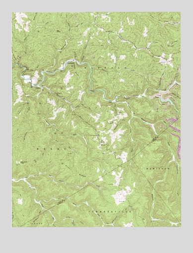
Swandale, WV USGS Topographic Map
Click on map above to begin viewing in our Map Viewer.

This topographic map contains these locations and features:
Feature Name Type Latitude Longitude GNIS ID View Map
Acree CemeteryCemeteryN38.4001°W80.9245°1534801View Map
Adkins BranchStreamN38.4723°W80.9534°1534816View Map
Barrenshe BranchStreamN38.4723°W80.9543°1535279View Map
Beech ForkStreamN38.3890°W80.9804°1535529View Map
Big KnobSummitN38.4890°W80.9668°1553895View Map
Bonetown GapGapN38.4493°W80.9157°1536215View Map
Cow RunStreamN38.4473°W80.9237°1537742View Map
Cow RunStreamN38.4943°W80.9395°1537748View Map
CressmontPopulated PlaceN38.4565°W80.9779°1549648View Map
Dille RunStreamN38.4590°W80.8795°1538189View Map
Dog RunStreamN38.4565°W80.9784°1538241View Map
Duffy RidgeRidgeN38.4059°W80.9540°1538412View Map
EaklePopulated PlaceN38.4470°W80.9270°1554347View Map
Elm CreekStreamN38.4334°W80.8962°1538689View Map
EnochPopulated PlaceN38.4245°W80.9345°1554405View Map
Enoch Baptist ChurchChurchN38.4229°W80.9334°1741399View Map
Ewings BranchStreamN38.4704°W80.9482°1538777View Map
Flat ForkStreamN38.4907°W80.9570°1539047View Map
Hickory ForkStreamN38.4518°W80.9815°1540210View Map
Hickory ForkStreamN38.4787°W80.8998°1540211View Map
Hogpen RunStreamN38.4107°W80.8773°1540369View Map
Ike ForkStreamN38.3815°W80.9693°1540657View Map
Jim Young ForkStreamN38.4029°W80.9915°1540902View Map
Kyle CemeteryCemeteryN38.4179°W80.9340°1541298View Map
Libertybowl BranchStreamN38.3765°W80.9268°1541826View Map
Lick RunStreamN38.4326°W80.9679°1541907View Map
Little Dog RunStreamN38.4440°W80.9545°1542088View Map
Lostlick RunStreamN38.3798°W80.9557°1542473View Map
Mount Ovis Primitive Baptist ChurchChurchN38.4357°W80.9251°1543733View Map
New Antioch Baptist ChurchChurchN38.4284°W80.9373°1544104View Map
Pleasant Dale Missionary Baptist ChurchChurchN38.4532°W80.9684°1544978View Map
Pond RidgeRidgeN38.4823°W80.8798°1545132View Map
Pond Ridge Lookout TowerLocaleN38.4807°W80.8829°1741417View Map
Ramsey CemeteryCemeteryN38.4415°W80.9215°1545404View Map
Ramsey School (historical)SchoolN38.4409°W80.9229°1741418View Map
Road ForkStreamN38.4395°W80.9101°1545809View Map
Robinson ForkStreamN38.4476°W80.9232°1545867View Map
Rockcamp RunStreamN38.4651°W80.9754°1545942View Map
Sand ForkStreamN38.4704°W80.9965°1546351View Map
Spanish Oak BranchStreamN38.4529°W80.8823°1547103View Map
Strickland RunStreamN38.4545°W80.8915°1547586View Map
Sugarcamp RunStreamN38.4362°W80.9126°1547682View Map
SwandalePopulated PlaceN38.4707°W80.9595°1555764View Map
Sycamore RunStreamN38.3865°W80.9773°1547845View Map
Taylor CreekStreamN38.4515°W80.9045°1547931View Map
Taylor Fork Refuse Disposal LakeReservoirN38.4518°W80.8915°1557424View Map
The GulfValleyN38.4662°W80.9887°1548004View Map
Thrashhouse RunStreamN38.4151°W80.8812°1548059View Map
Walker ForkStreamN38.4915°W80.9812°1548725View Map
Wallowhole ForkStreamN38.4570°W80.9820°1548742View Map
Wallowhole KnobSummitN38.4129°W80.9940°1555909View Map
Whetstone CreekStreamN38.4682°W80.9415°1549003View Map
Widen-Taylor Fork DamDamN38.4518°W80.8915°1557423View Map
Wilson CemeteryCemeteryN38.3898°W80.9207°1549210View Map

Note: Coordinates in the location and feature list above are referenced to NAD83 datum.


Copyright (C) 2008-2024 Ryan Niemi / Sunset Dynamics ... All Rights Reserved