TopoQuest Logo
Do you find TopoQuest useful?
Help keep TopoQuest running and adding new maps/features by donating!
Bitcoin:  19c7KJd3qBynnjoSw5npx9KScwjBe4ifkT
Litecoin:  LXs6TkuXGGXo1vDsWCkWVdjQX94eUKd6ui
Home View Maps Find Maps Find Places Resources & Links


New Ellenton SE, South Carolina Topographic Map

USGS Map Title: New Ellenton SE, SC
USGS Map MRC: 33081C5
DRG (GeoTIFF) Download: o33081c5.tif


Neighboring USGS Topographic Map Quads:


  New Ellenton, SC  
33081D6
 

  Windsor, SC  
33081D5
 

  Williston, SC  
33081D4
 

  New Ellenton SW, SC  
33081C6
 

  New Ellenton SE, SC  
33081C5
 

  Long Branch, SC  
33081C4
 

  Girard NW, SC  
33081B6
 

  Girard NE, SC  
33081B5
 

  Snelling, SC  
33081B4


Map MRC Location:

N34°
W82°
N34°
W81°
H8 H7 H6 H5 H4 H3 H2 H1
G8 G7 G6 G5 G4 G3 G2 G1
F8 F7 F6 F5 F4 F3 F2 F1
E8 E7 E6 E5 E4 E3 E2 E1
D8 D7 D6 D5 D4 D3 D2 D1
C8 C7 C6 C5 C4 C3 C2 C1
B8 B7 B6 B5 B4 B3 B2 B1
A8 A7 A6 A5 A4 A3 A2 A1
N33°
W82°
N33°
W81°

New Ellenton SE, SC USGS 1:24K Topographic Map Preview:
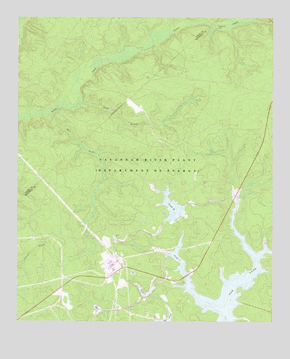
New Ellenton SE, SC USGS Topographic Map
Click on map above to begin viewing in our Map Viewer.

This topographic map contains these locations and features:
Feature Name Type Latitude Longitude GNIS ID View Map
Canaan Church (historical)ChurchN33.2729°W81.6021°1235439View Map
Corleys Mill Pond (historical)ReservoirN33.2552°W81.5257°1235443View Map
Dorch CemeteryCemeteryN33.3507°W81.5623°1236302View Map
Fair Branch Church (historical)ChurchN33.3004°W81.6043°1235467View Map
Fair Branch School (historical)SchoolN33.3051°W81.6057°1235468View Map
Fairmont Church (historical)ChurchN33.3640°W81.5257°1235469View Map
Green Branch School (historical)SchoolN33.2540°W81.5598°1235483View Map
Greenland (historical)Populated PlaceN33.2838°W81.6123°1235484View Map
Greenland School (historical)SchoolN33.2890°W81.6040°1235485View Map
Gum Pond School (historical)SchoolN33.3313°W81.5259°1235488View Map
Hailey Branch School (historical)SchoolN33.3051°W81.5629°1235490View Map
Hawthorne Fire TowerLocaleN33.3613°W81.6096°1731892View Map
Joyce BranchStreamN33.2543°W81.5234°1235498View Map
Joyce Branch Church (historical)ChurchN33.2651°W81.5429°1235499View Map
Kennedys PondLakeN33.3707°W81.5265°1246235View Map
Mill CreekStreamN33.3351°W81.6090°1224530View Map
Mossy School (historical)SchoolN33.3349°W81.6059°1236442View Map
Mount Pleasant School (historical)SchoolN33.3346°W81.5026°1235514View Map
Pleasant Hill Church (historical)ChurchN33.3349°W81.5026°1235523View Map
Pond BReservoirN33.2975°W81.5487°1225595View Map
Pond FiveReservoirN33.2560°W81.5704°1225594View Map
Pond FourLakeN33.2699°W81.5678°1225593View Map
Pond TwoLakeN33.2551°W81.5848°1225592View Map
Pump House Number 6BuildingN33.2507°W81.5579°1731903View Map
Reedy BranchStreamN33.3393°W81.5948°1225803View Map
Saint Johns Church (historical)ChurchN33.3543°W81.5826°1236512View Map
Savannah River Plant Pond B D-3078 DamDamN33.2926°W81.5459°1239746View Map
Savannah River Plant Pond Dam Number Five D-3076DamN33.2610°W81.5598°1239751View Map
Savannah River Plant Pond Dam Number Four D-3075DamN33.2701°W81.5679°1239750View Map
Savannah River Plant Pond Number Two D-3074 DamDamN33.2551°W81.5848°1239749View Map
Scott CemeteryCemeteryN33.3074°W81.5320°1235544View Map
Thalmans Mill (historical)LocaleN33.2890°W81.5187°1235560View Map
Zion Grove Church (historical)ChurchN33.2910°W81.5732°1235579View Map

Note: Coordinates in the location and feature list above are referenced to NAD83 datum.


Copyright (C) 2008-2025 Ryan Niemi / Sunset Dynamics ... All Rights Reserved