TopoQuest Logo
Do you find TopoQuest useful?
Help keep TopoQuest running and adding new maps/features by donating!
Bitcoin:  19c7KJd3qBynnjoSw5npx9KScwjBe4ifkT
Litecoin:  LXs6TkuXGGXo1vDsWCkWVdjQX94eUKd6ui
Home View Maps Find Maps Find Places Resources & Links


Long Branch, South Carolina Topographic Map

USGS Map Title: Long Branch, SC
USGS Map MRC: 33081C4
DRG (GeoTIFF) Download: o33081c4.tif


Neighboring USGS Topographic Map Quads:


  Windsor, SC  
33081D5
 

  Williston, SC  
33081D4
 

  Springfield, SC  
33081D3
 

  New Ellenton SE, SC  
33081C5
 

  Long Branch, SC  
33081C4
 

  Blackville, SC  
33081C3
 

  Girard NE, SC  
33081B5
 

  Snelling, SC  
33081B4
 

  Barnwell, SC  
33081B3


Map MRC Location:

N34°
W82°
N34°
W81°
H8 H7 H6 H5 H4 H3 H2 H1
G8 G7 G6 G5 G4 G3 G2 G1
F8 F7 F6 F5 F4 F3 F2 F1
E8 E7 E6 E5 E4 E3 E2 E1
D8 D7 D6 D5 D4 D3 D2 D1
C8 C7 C6 C5 C4 C3 C2 C1
B8 B7 B6 B5 B4 B3 B2 B1
A8 A7 A6 A5 A4 A3 A2 A1
N33°
W82°
N33°
W81°

Long Branch, SC USGS 1:24K Topographic Map Preview:
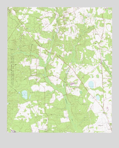
Long Branch, SC USGS Topographic Map
Click on map above to begin viewing in our Map Viewer.

This topographic map contains these locations and features:
Feature Name Type Latitude Longitude GNIS ID View Map
Andersons Pond D-3059 DamDamN33.3301°W81.4482°1239722View Map
Barnwell Army Air Field (historical)MilitaryN33.2583°W81.3889°1985991View Map
Barnwell CountyCivilN33.2661°W81.4350°1247983View Map
Barnwell County Sheriff's OfficeBuildingN33.2519°W81.3766°2334804View Map
Barnwell Regional AirportAirportN33.2595°W81.3808°1251849View Map
Bates CemeteryCemeteryN33.3532°W81.4776°1220356View Map
Bates Pond D-3072 DamDamN33.3668°W81.4032°1239723View Map
Bell Pond Baptist ChurchChurchN33.3265°W81.4382°1245042View Map
Bell Pond School (historical)SchoolN33.3260°W81.4379°1235421View Map
Bells Mill (historical)LocaleN33.3668°W81.4373°1235422View Map
Bolen PondReservoirN33.3115°W81.4279°1220880View Map
Bolens Fishing Lake D-3063 DamDamN33.3090°W81.4290°1239724View Map
Buck CreekStreamN33.2907°W81.4326°1221067View Map
Cedar Grove School (historical)SchoolN33.3204°W81.4318°1235448View Map
Craig Pond School (historical)SchoolN33.2882°W81.4857°1235451View Map
Craigs PondLakeN33.2877°W81.4789°1235452View Map
Dicks Pond D-3069 DamDamN33.3601°W81.4082°1239728View Map
Ernest Rand Memorial State ForestForestN33.3099°W81.4918°1222300View Map
Great Cypress Baptist ChurchChurchN33.3001°W81.3862°1245818View Map
Great Cypress School (historical)SchoolN33.3004°W81.3859°1235482View Map
Greens Academy School (historical)SchoolN33.3493°W81.4607°1235486View Map
Hair CemeteryCemeteryN33.3488°W81.3934°1222971View Map
Long BranchPopulated PlaceN33.3221°W81.3879°1231501View Map
Long Branch Baptist ChurchChurchN33.3199°W81.3884°1235504View Map
Long Branch Fire DepartmentBuildingN33.3077°W81.4069°2578696View Map
Long Branch School (historical)SchoolN33.3190°W81.3884°1235506View Map
New Jerusalem Baptist ChurchChurchN33.3093°W81.3871°1249837View Map
Old Field CemeteryCemeteryN33.3374°W81.4604°1225176View Map
Pleasant Hill School (historical)SchoolN33.3246°W81.4943°1235524View Map
Rosemary ChurchChurchN33.3660°W81.4332°1226027View Map
Rosemary CreekStreamN33.2907°W81.4326°1226028View Map
Saint Paul Church (historical)ChurchN33.2588°W81.4629°1235537View Map
Saint Paul School (historical)SchoolN33.2588°W81.4629°1235538View Map
Saint Peter Baptist ChurchChurchN33.3743°W81.3818°1235539View Map
Saint Peters Church (historical)ChurchN33.3715°W81.3837°1235540View Map
Saint Peters School (historical)SchoolN33.3713°W81.3837°1235541View Map
Seven Pines CemeteryCemeteryN33.2532°W81.4520°1226504View Map
Seven Pines Church (historical)ChurchN33.2526°W81.4521°1235547View Map
Springfield Baptist ChurchChurchN33.2854°W81.3973°1251009View Map
Woods CemeteryCemeteryN33.3176°W81.4909°1227701View Map
Woodward Mill (historical)LocaleN33.3335°W81.4857°1235578View Map

Note: Coordinates in the location and feature list above are referenced to NAD83 datum.


Copyright (C) 2008-2025 Ryan Niemi / Sunset Dynamics ... All Rights Reserved