TopoQuest Logo
Do you find TopoQuest useful?
Help keep TopoQuest running and adding new maps/features by donating!
Bitcoin:  19c7KJd3qBynnjoSw5npx9KScwjBe4ifkT
Litecoin:  LXs6TkuXGGXo1vDsWCkWVdjQX94eUKd6ui
Home View Maps Find Maps Find Places Resources & Links


Glenwood, North Carolina Topographic Map

USGS Map Title: Glenwood, NC
USGS Map MRC: 35081E8
DRG (GeoTIFF) Download: o35081e8.tif


Neighboring USGS Topographic Map Quads:


  Marion West, NC  
35082F1
 

  Marion East, NC  
35081F8
 

  Glen Alpine, NC  
35081F7
 

  Sugar Hill, NC  
35082E1
 

  Glenwood, NC  
35081E8
 

  Dysartsville, NC  
35081E7
 

  Shingle Hollow, NC  
35082D1
 

  Rutherfordton North, NC  
35081D8
 

  Sunshine, NC  
35081D7


Map MRC Location:

N36°
W82°
N36°
W81°
H8 H7 H6 H5 H4 H3 H2 H1
G8 G7 G6 G5 G4 G3 G2 G1
F8 F7 F6 F5 F4 F3 F2 F1
E8 E7 E6 E5 E4 E3 E2 E1
D8 D7 D6 D5 D4 D3 D2 D1
C8 C7 C6 C5 C4 C3 C2 C1
B8 B7 B6 B5 B4 B3 B2 B1
A8 A7 A6 A5 A4 A3 A2 A1
N35°
W82°
N35°
W81°

Glenwood, NC USGS 1:24K Topographic Map Preview:
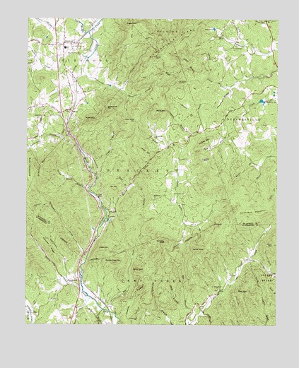
Glenwood, NC USGS Topographic Map
Click on map above to begin viewing in our Map Viewer.

This topographic map contains these locations and features:
Feature Name Type Latitude Longitude GNIS ID View Map
Baker BranchStreamN35.6004°W81.9157°980443View Map
Bakers CreekStreamN35.5440°W81.9598°980452View Map
Barnes BranchStreamN35.6007°W81.9087°980562View Map
Beaverdam BranchStreamN35.5782°W81.9909°980824View Map
Bethel ChurchChurchN35.5851°W81.9926°981143View Map
Box CreekStreamN35.5046°W81.9551°981781View Map
Brackettown CemeteryCemeteryN35.5535°W81.9207°981799View Map
California BranchStreamN35.5185°W81.9795°982430View Map
Camel KnobSummitN35.5304°W81.9137°982477View Map
Camp BranchStreamN35.5640°W81.9687°982500View Map
Camp Creek Baptist Church CemeteryCemeteryN35.5146°W81.9036°1008416View Map
Camp Creek ChurchChurchN35.5146°W81.9034°1019488View Map
Cedar KnobSummitN35.5221°W81.9443°982882View Map
Chestnut MountainSummitN35.5651°W81.9937°1010255View Map
Coal Pit MountainSummitN35.5668°W81.9104°1019710View Map
Cobb BranchStreamN35.5035°W81.9970°983313View Map
Conoway KnobSummitN35.5337°W81.9301°983464View Map
Cove BranchStreamN35.5410°W81.9143°983617View Map
FeroPopulated PlaceN35.5868°W81.9776°985056View Map
Fork MountainSummitN35.5329°W81.8762°1020321View Map
Gap BranchStreamN35.5001°W81.9182°985540View Map
GlenwoodPopulated PlaceN35.6146°W81.9820°985738View Map
Glenwood Elementary SchoolSchoolN35.6165°W81.9798°1006754View Map
Glenwood Volunteer Fire DepartmentBuildingN35.6122°W81.9816°2639831View Map
Goose CreekStreamN35.6196°W81.9695°1023992View Map
Gray BranchStreamN35.5554°W81.9501°985982View Map
Hensley RidgeRidgeN35.5321°W81.9879°986631View Map
Hicks BranchStreamN35.6235°W81.9915°1012025View Map
High Shoals CreekStreamN35.5976°W81.8982°986767View Map
Huntsville BranchStreamN35.5960°W81.9537°987276View Map
Huntsville MountainsSummitN35.6101°W81.9370°987277View Map
Indian Grave GapGapN35.5837°W81.9448°987360View Map
Jackson BranchStreamN35.5776°W81.9173°987488View Map
Lake DavidReservoirN35.6212°W81.9067°983973View Map
Laurel Hill ChurchChurchN35.6140°W81.8970°988199View Map
Lookadoo MountainSummitN35.5457°W81.8918°989024View Map
Macedonia ChurchChurchN35.5768°W81.9368°989185View Map
Marks MountainSummitN35.5873°W81.9337°989349View Map
Matt Brooks DamDamN35.5185°W81.9032°999062View Map
Matt Brooks LakeReservoirN35.5185°W81.9032°999061View Map
Mill BranchStreamN35.6160°W81.8890°989876View Map
Moores BranchStreamN35.5723°W81.9226°990188View Map
Mount Moriah ChurchChurchN35.5523°W81.9368°990441View Map
Neal CemeteryCemeteryN35.6071°W81.9990°990881View Map
Newcomb BranchStreamN35.5410°W81.9198°991121View Map
Piney MountainSummitN35.5135°W81.8918°992379View Map
Pleasant Hill CemeteryCemeteryN35.5023°W81.9440°992512View Map
Pleasant Hill Church (historical)ChurchN35.5023°W81.9443°1008458View Map
Pogue MountainSummitN35.6223°W81.9479°1022017View Map
Rockey Face MountainSummitN35.5254°W81.9554°993534View Map
Rockhouse CreekStreamN35.5276°W81.9695°993545View Map
Rockhouse MountainSummitN35.5885°W81.9604°1022332View Map
Rust MountainSummitN35.5840°W81.9670°993824View Map
Scrub Grass BranchStreamN35.5543°W81.9684°994443View Map
Shoal BranchStreamN35.5062°W81.9195°994745View Map
Spruce BranchStreamN35.5851°W81.9140°995377View Map
Stanfords CreekStreamN35.6090°W81.9698°995404View Map
Stoney CreekStreamN35.5165°W81.9718°995545View Map
Structure Number Fifteen DamDamN35.6151°W81.8882°999157View Map
Structure Number Fifteen LakeReservoirN35.6157°W81.8888°999158View Map
Structure Number Nineteen DamDamN35.5918°W81.8815°999133View Map
Structure Number Nineteen LakeReservoirN35.5918°W81.8824°999132View Map
Structure Number Six B DamDamN35.5985°W81.9515°999147View Map
Structure Number Six B LakeReservoirN35.5994°W81.9500°999146View Map
Thermal CityPopulated PlaceN35.5193°W81.9748°1006388View Map
Thermal City Methodist ChurchChurchN35.5162°W81.9784°1008469View Map
Township of BrackettCivilN35.5654°W81.9476°1026891View Map
Township of DysartsvilleCivilN35.6107°W81.8756°1026893View Map
Township of GlenwoodCivilN35.6141°W81.9865°1026894View Map
Trio (historical)Populated PlaceN35.5085°W81.9151°1008471View Map
Turkey MountainSummitN35.5743°W81.9123°996338View Map
Vein MountainPopulated PlaceN35.5521°W81.9640°1023076View Map
Vein MountainSummitN35.5560°W81.9559°1023077View Map
Vein Mountain ChurchChurchN35.5440°W81.9587°996604View Map
W W Jones DamDamN35.5185°W81.9998°999064View Map
W W Jones LakeReservoirN35.5185°W81.9998°999063View Map
Ward HollowValleyN35.5680°W81.9381°996779View Map
Weaver BranchStreamN35.5657°W81.8834°996903View Map
Wheeler BranchStreamN35.5476°W81.9873°997106View Map
Wolf MountainSummitN35.5307°W81.9623°1023301View Map
Wolfpen BranchStreamN35.5573°W81.9476°997549View Map
Yellow GapGapN35.5721°W81.9120°997709View Map

Note: Coordinates in the location and feature list above are referenced to NAD83 datum.


Copyright (C) 2008-2024 Ryan Niemi / Sunset Dynamics ... All Rights Reserved