TopoQuest Logo
Do you find TopoQuest useful?
Help keep TopoQuest running and adding new maps/features by donating!
Bitcoin:  19c7KJd3qBynnjoSw5npx9KScwjBe4ifkT
Litecoin:  LXs6TkuXGGXo1vDsWCkWVdjQX94eUKd6ui
Home View Maps Find Maps Find Places Resources & Links


Goodspeed Butte, Montana Topographic Map

USGS Map Title: Goodspeed Butte, MT
USGS Map MRC: 45106C1
DRG (GeoTIFF) Download: o45106c1.tif


Neighboring USGS Topographic Map Quads:


  King Mountain, MT  
45106D2
 

  Yager Butte, MT  
45106D1
 

  Threemile Buttes, MT  
45105D8
 

  Fort Howes, MT  
45106C2
 

  Goodspeed Butte, MT  
45106C1
 

  Phillips Butte, MT  
45105C8
 

  Otter, MT  
45106B2
 

  Reanus Cone, MT  
45106B1
 

  Sayle, MT  
45105B8


Map MRC Location:

N46°
W107°
N46°
W106°
H8 H7 H6 H5 H4 H3 H2 H1
G8 G7 G6 G5 G4 G3 G2 G1
F8 F7 F6 F5 F4 F3 F2 F1
E8 E7 E6 E5 E4 E3 E2 E1
D8 D7 D6 D5 D4 D3 D2 D1
C8 C7 C6 C5 C4 C3 C2 C1
B8 B7 B6 B5 B4 B3 B2 B1
A8 A7 A6 A5 A4 A3 A2 A1
N45°
W107°
N45°
W106°

Goodspeed Butte, MT USGS 1:24K Topographic Map Preview:
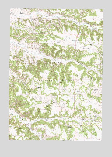
Goodspeed Butte, MT USGS Topographic Map
Click on map above to begin viewing in our Map Viewer.

This topographic map contains these locations and features:
Feature Name Type Latitude Longitude GNIS ID View Map
06S38E24ADAC01 WellWellN45.3064°W106.0150°808834View Map
06S46E33DDB_01 WellWellN45.2675°W106.1189°808650View Map
Ash Creek ReservoirReservoirN45.3446°W106.0387°779160View Map
Ash Creek Reservoir Number TwoReservoirN45.3525°W106.0852°779161View Map
Burnt Rock SpringSpringN45.3527°W106.0337°780653View Map
Coal Bank SpringSpringN45.2781°W106.0320°781429View Map
Dry Gulch ReservoirReservoirN45.3002°W106.0871°782639View Map
Dry Gulch SpringSpringN45.2963°W106.0985°782640View Map
Elk Creek Reservoir Number ThreeReservoirN45.3703°W106.1129°783077View Map
Elk Creek Reservoir Number TwoReservoirN45.3640°W106.0969°783076View Map
Elk Creek Sawmill SpringSpringN45.3557°W106.0104°783078View Map
Goodspeed ButteSummitN45.3117°W106.0350°784097View Map
Goodspeed DrawValleyN45.3236°W106.0508°784098View Map
Goodspeed Draw ReservoirReservoirN45.2987°W106.0539°784099View Map
Goodspeed Draw SpringSpringN45.3052°W106.0545°784100View Map
Griffin CouleeValleyN45.2672°W106.1036°784332View Map
Hedum DrawValleyN45.2700°W106.0750°784707View Map
Hedum SpringSpringN45.2823°W106.0722°784708View Map
Horse Range SpringSpringN45.3400°W106.0775°785061View Map
Howes ReservoirReservoirN45.2967°W106.0349°785118View Map
Kelty SpringSpringN45.2814°W106.0549°785671View Map
Lyon Divide Reservoir DamDamN45.3267°W106.0056°796013View Map
Mud SpringSpringN45.3410°W106.0157°787809View Map
Mystery SpringSpringN45.3344°W106.0601°787895View Map
North Fork Taylor CreekStreamN45.2647°W106.1003°788259View Map
Ole SpringSpringN45.3214°W106.0693°788433View Map
Overall SpringSpringN45.3688°W106.0753°788530View Map
Pierce SpringSpringN45.3604°W106.0142°788848View Map
Piper DrawValleyN45.3180°W106.0214°788946View Map
Piper Draw SpringSpringN45.2984°W106.0115°788947View Map
Price ReservoirReservoirN45.3435°W106.0631°789185View Map
Sheep SpringSpringN45.2732°W106.0074°790371View Map
South Fork Taylor CreekStreamN45.2650°W106.1000°791067View Map
Stanley SpringSpringN45.2642°W106.0303°791430View Map
Stewart Reservoir Number TwoReservoirN45.2627°W106.0456°791516View Map
Tate WellWellN45.3333°W106.1006°791902View Map
Taylor Creek Sawmill SpringSpringN45.2577°W106.0128°791917View Map
Wilbur SpringSpringN45.2510°W106.0978°793279View Map

Note: Coordinates in the location and feature list above are referenced to NAD83 datum.


Copyright (C) 2008-2025 Ryan Niemi / Sunset Dynamics ... All Rights Reserved