TopoQuest Logo
Do you find TopoQuest useful?
Help keep TopoQuest running and adding new maps/features by donating!
Bitcoin:  19c7KJd3qBynnjoSw5npx9KScwjBe4ifkT
Litecoin:  LXs6TkuXGGXo1vDsWCkWVdjQX94eUKd6ui
Home View Maps Find Maps Find Places Resources & Links


Grand Junction, Tennessee Topographic Map

USGS Map Title: Grand Junction, TN
USGS Map MRC: 35089A2
DRG (GeoTIFF) Download: o35089a2.tif


Neighboring USGS Topographic Map Quads:


  Somerville, TN  
35089B3
 

  Hickory Valley, TN  
35089B2
 

  Middleburg, TN  
35089B1
 

  Moscow SE, TN  
35089A3
 

  Grand Junction, TN  
35089A2
 

  Saulsbury, TN  
35089A1
 

  Lamar, MS  
34089H3
 

  Canaan, MS  
34089H2
 

  Camp Hill, MS  
34089H1


Map MRC Location:

N36°
W90°
N36°
W89°
H8 H7 H6 H5 H4 H3 H2 H1
G8 G7 G6 G5 G4 G3 G2 G1
F8 F7 F6 F5 F4 F3 F2 F1
E8 E7 E6 E5 E4 E3 E2 E1
D8 D7 D6 D5 D4 D3 D2 D1
C8 C7 C6 C5 C4 C3 C2 C1
B8 B7 B6 B5 B4 B3 B2 B1
A8 A7 A6 A5 A4 A3 A2 A1
N35°
W90°
N35°
W89°

Grand Junction, TN USGS 1:24K Topographic Map Preview:
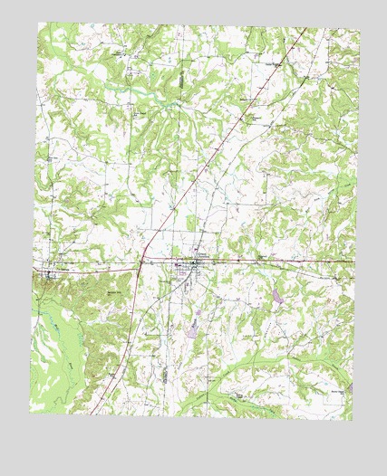
Grand Junction, TN USGS Topographic Map
Click on map above to begin viewing in our Map Viewer.

This topographic map contains these locations and features:
Feature Name Type Latitude Longitude GNIS ID View Map
Ames PlantationLocaleN35.1154°W89.2167°1275660View Map
Ames School (historical)SchoolN35.1154°W89.2106°1319786View Map
Center PointPopulated PlaceN35.1134°W89.1556°1647501View Map
Center Point ChurchChurchN35.1131°W89.1565°1280138View Map
City of Grand JunctionCivilN35.0500°W89.1888°2403724View Map
Clemmons BottomValleyN35.0201°W89.1628°1280699View Map
Gordon HillSummitN35.0387°W89.2209°1285698View Map
Grand JunctionPopulated PlaceN35.0490°W89.1870°1285817View Map
Grand Junction CemeteryCemeteryN35.0434°W89.1942°1285818View Map
Grand Junction Elementary SchoolSchoolN35.0481°W89.1928°1319755View Map
Grand Junction Fire DepartmentBuildingN35.0484°W89.1863°2653725View Map
Grand Junction Police DepartmentBuildingN35.0484°W89.1860°2765977View Map
Grand Junction Post OfficePost OfficeN35.0495°W89.1864°1651310View Map
Hopewell ChurchChurchN35.0512°W89.1626°1288298View Map
Hunts Chapel SchoolSchoolN35.0090°W89.1281°1288763View Map
Immanuel Episcopal ChurchChurchN35.0440°W89.2420°1319840View Map
Indian Creek Watershed Number Four DamDamN35.0368°W89.1551°1301498View Map
Indian Creek Watershed Number Four LakeReservoirN35.0390°W89.1550°1301499View Map
Indian Creek Watershed Number Seven DamDamN35.0118°W89.1267°1301461View Map
Indian Creek Watershed Number Two DamDamN35.0268°W89.1884°1301488View Map
Indian Creek Watershed Number Two LakeReservoirN35.0277°W89.1873°1301489View Map
Jones Chapel SchoolSchoolN35.0954°W89.2123°1289777View Map
La GrangePopulated PlaceN35.0454°W89.2437°1303479View Map
La Grange Elementary SchoolSchoolN35.0490°W89.2442°1319848View Map
La Grange Methodist ChurchChurchN35.0456°W89.2451°1319849View Map
La Grange Post OfficePost OfficeN35.0452°W89.2438°1651341View Map
La Grange Volunteer Fire DepartmentBuildingN35.0449°W89.2434°2654288View Map
LaGrange CemeteryCemeteryN35.0562°W89.2451°1290434View Map
Moody CreekStreamN35.0077°W89.1815°694026View Map
New Zion ChurchChurchN35.0809°W89.2451°1319878View Map
New Zion SchoolSchoolN35.0812°W89.2451°1295675View Map
Old Jonah ChurchChurchN35.0948°W89.2120°1319887View Map
Pleasant Grove CemeteryCemeteryN35.0429°W89.1965°1297801View Map
Prospect ChurchChurchN35.1018°W89.1662°1298576View Map
Prospect SchoolSchoolN35.0962°W89.1665°1298585View Map
Scott CemeteryCemeteryN35.0115°W89.1812°1300928View Map
Spring ChapelChurchN35.0065°W89.1695°1271060View Map
St Somewhere AirportAirportN35.0240°W89.2037°2675481View Map
Town of La GrangeCivilN35.0475°W89.2396°2405963View Map
Woods SchoolSchoolN35.0123°W89.2173°1275090View Map

Note: Coordinates in the location and feature list above are referenced to NAD83 datum.


Copyright (C) 2008-2025 Ryan Niemi / Sunset Dynamics ... All Rights Reserved