TopoQuest Logo
Do you find TopoQuest useful?
Help keep TopoQuest running and adding new maps/features by donating!
Bitcoin:  19c7KJd3qBynnjoSw5npx9KScwjBe4ifkT
Litecoin:  LXs6TkuXGGXo1vDsWCkWVdjQX94eUKd6ui
Home View Maps Find Maps Find Places Resources & Links


Moscow SE, Tennessee Topographic Map

USGS Map Title: Moscow SE, TN
USGS Map MRC: 35089A3
DRG (GeoTIFF) Download: o35089a3.tif


Neighboring USGS Topographic Map Quads:


  Macon, TN  
35089B4
 

  Somerville, TN  
35089B3
 

  Hickory Valley, TN  
35089B2
 

  Moscow, TN  
35089A4
 

  Moscow SE, TN  
35089A3
 

  Grand Junction, TN  
35089A2
 

  Slayden, MS  
34089H4
 

  Lamar, MS  
34089H3
 

  Canaan, MS  
34089H2


Map MRC Location:

N36°
W90°
N36°
W89°
H8 H7 H6 H5 H4 H3 H2 H1
G8 G7 G6 G5 G4 G3 G2 G1
F8 F7 F6 F5 F4 F3 F2 F1
E8 E7 E6 E5 E4 E3 E2 E1
D8 D7 D6 D5 D4 D3 D2 D1
C8 C7 C6 C5 C4 C3 C2 C1
B8 B7 B6 B5 B4 B3 B2 B1
A8 A7 A6 A5 A4 A3 A2 A1
N35°
W90°
N35°
W89°

Moscow SE, TN USGS 1:24K Topographic Map Preview:
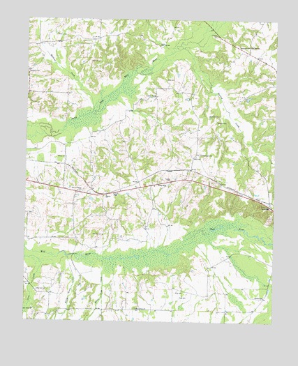
Moscow SE, TN USGS Topographic Map
Click on map above to begin viewing in our Map Viewer.

This topographic map contains these locations and features:
Feature Name Type Latitude Longitude GNIS ID View Map
Ambrose CemeteryCemeteryN35.0359°W89.3365°1275655View Map
Anderson ChapelChurchN35.0937°W89.3109°1304829View Map
Anderson Grove ChurchChurchN35.0695°W89.2878°1319787View Map
Anderson Grove SchoolSchoolN35.0693°W89.2878°1275715View Map
Beasley CreekStreamN35.1134°W89.2973°1276684View Map
Blackwell SchoolSchoolN35.0104°W89.2551°1277628View Map
Commissioner District 7CivilN35.0706°W89.3084°2464605View Map
Do Right Church (historical)ChurchN35.0134°W89.3006°1319804View Map
Early Grove CreekStreamN35.0268°W89.3537°669551View Map
Ewell ChapelChurchN35.0529°W89.3306°1283937View Map
Forty FivePopulated PlaceN35.0573°W89.3090°1315071View Map
Forty Five Baptist ChurchChurchN35.0565°W89.3103°1319816View Map
Forty Five School (historical)SchoolN35.0565°W89.3098°1319817View Map
Franklin CemeteryCemeteryN35.0590°W89.3026°1284819View Map
Franklin SchoolSchoolN35.0523°W89.3345°1284834View Map
Fredonia School (historical)SchoolN35.1073°W89.3748°1319820View Map
Green CemeteryCemeteryN35.1001°W89.3051°1286071View Map
Hawks Nest AirportAirportN35.1189°W89.3683°2675479View Map
Hickory Grove CemeteryCemeteryN35.0054°W89.3187°1319834View Map
Hickory Grove ChurchChurchN35.0051°W89.3190°1287586View Map
Hickory Grove School (historical)SchoolN35.0051°W89.3181°1319835View Map
Holmes CreekStreamN35.0970°W89.3478°1311579View Map
Jackson Church (historical)ChurchN35.0515°W89.3356°1319842View Map
Johnson CemeteryCemeteryN35.1190°W89.2801°1289543View Map
Jonesboro SchoolSchoolN35.1140°W89.2645°1289827View Map
Liberty ChurchChurchN35.0676°W89.3556°1291120View Map
Liberty School (historical)SchoolN35.0681°W89.3556°1319852View Map
Macedonia CemeteryCemeteryN35.1034°W89.3745°1292405View Map
Mayos CemeteryCemeteryN35.0684°W89.2901°1293025View Map
Moody CemeteryCemeteryN35.1145°W89.3087°1294211View Map
Moscow-La Grange Division (historical)CensusN35.0618°W89.3631°1269254View Map
Mount Tena CreekStreamN35.0265°W89.3356°674284View Map
New Bethel CemeteryCemeteryN35.0051°W89.3709°1319875View Map
New Bethel ChurchChurchN35.0048°W89.3704°1295420View Map
New Friendship CemeteryCemeteryN35.0537°W89.3476°1295478View Map
New Zion CemeteryCemeteryN35.0129°W89.3687°1295668View Map
New Zion Church (historical)ChurchN35.0118°W89.3690°1319877View Map
New Zion School (historical)SchoolN35.0120°W89.3690°1319879View Map
RatherPopulated PlaceN35.0629°W89.3031°1315784View Map
Rives CemeteryCemeteryN35.0101°W89.2973°1299540View Map
Rives CemeteryCemeteryN35.0123°W89.2959°1299541View Map
Shepard CreekStreamN35.1209°W89.2856°1311583View Map
Shepherd CemeteryCemeteryN35.0829°W89.2798°1270040View Map
Shepherd CemeteryCemeteryN35.0856°W89.2787°1270041View Map
Shiloh CemeteryCemeteryN35.1076°W89.3390°1270075View Map
Sunnyside School (historical)SchoolN35.0931°W89.3109°1319928View Map
Union Grove ChurchChurchN35.1143°W89.2640°1273219View Map
Watkins CemeteryCemeteryN35.1187°W89.3603°1273906View Map
Watkins CreekStreamN35.0862°W89.3428°1273909View Map
White School (historical)SchoolN35.0206°W89.3009°1319936View Map
Wilson FieldAirportN35.0906°W89.2815°2675480View Map

Note: Coordinates in the location and feature list above are referenced to NAD83 datum.


Copyright (C) 2008-2024 Ryan Niemi / Sunset Dynamics ... All Rights Reserved