TopoQuest Logo
Do you find TopoQuest useful?
Help keep TopoQuest running and adding new maps/features by donating!
Bitcoin:  19c7KJd3qBynnjoSw5npx9KScwjBe4ifkT
Litecoin:  LXs6TkuXGGXo1vDsWCkWVdjQX94eUKd6ui
Home View Maps Find Maps Find Places Resources & Links


Somerville, Tennessee Topographic Map

USGS Map Title: Somerville, TN
USGS Map MRC: 35089B3
DRG (GeoTIFF) Download: o35089b3.tif


Neighboring USGS Topographic Map Quads:


  Lambert, TN  
35089C4
 

  Laconia, TN  
35089C3
 

  Whiteville, TN  
35089C2
 

  Macon, TN  
35089B4
 

  Somerville, TN  
35089B3
 

  Hickory Valley, TN  
35089B2
 

  Moscow, TN  
35089A4
 

  Moscow SE, TN  
35089A3
 

  Grand Junction, TN  
35089A2


Map MRC Location:

N36°
W90°
N36°
W89°
H8 H7 H6 H5 H4 H3 H2 H1
G8 G7 G6 G5 G4 G3 G2 G1
F8 F7 F6 F5 F4 F3 F2 F1
E8 E7 E6 E5 E4 E3 E2 E1
D8 D7 D6 D5 D4 D3 D2 D1
C8 C7 C6 C5 C4 C3 C2 C1
B8 B7 B6 B5 B4 B3 B2 B1
A8 A7 A6 A5 A4 A3 A2 A1
N35°
W90°
N35°
W89°

Somerville, TN USGS 1:24K Topographic Map Preview:
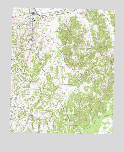
Somerville, TN USGS Topographic Map
Click on map above to begin viewing in our Map Viewer.

This topographic map contains these locations and features:
Feature Name Type Latitude Longitude GNIS ID View Map
Asbury CemeteryCemeteryN35.1695°W89.3242°1319788View Map
Asbury ChurchChurchN35.1715°W89.3228°1275921View Map
Asbury School (historical)SchoolN35.1684°W89.3253°1319789View Map
Bennetts CreekStreamN35.2470°W89.3206°1277019View Map
Black CreekStreamN35.1873°W89.3356°1277558View Map
Brooks CemeteryCemeteryN35.2037°W89.3078°1319796View Map
Brooks SchoolSchoolN35.2037°W89.3070°1278491View Map
Brown CemeteryCemeteryN35.2054°W89.3537°1278522View Map
Center School (historical)SchoolN35.1568°W89.3531°1319800View Map
Clark CemeteryCemeteryN35.1759°W89.3528°1280590View Map
Dupree CemeteryCemeteryN35.1890°W89.2898°1283218View Map
Ebenezer CemeteryCemeteryN35.1426°W89.3495°1319807View Map
Ebenezer ChurchChurchN35.1426°W89.3501°1283465View Map
Evergreen CemeteryCemeteryN35.1636°W89.3658°1283923View Map
Fayette County Ambulance ServiceBuildingN35.2463°W89.3490°2697384View Map
Fayette County CourthouseBuildingN35.2440°W89.3501°1319943View Map
Fayette County Farm (historical)LocaleN35.2151°W89.2876°1319811View Map
Fayette County Fire Department District 15 Station 2BuildingN35.2440°W89.3491°2653773View Map
Fayette County LandfillLocaleN35.2244°W89.3561°2677899View Map
Fayette County Sheriff's OfficeBuildingN35.2244°W89.3636°2765812View Map
Fayette County Training School (historical)SchoolN35.2181°W89.3512°1319812View Map
Fayette Ware High SchoolSchoolN35.2373°W89.3481°1319814View Map
Gatley CemeteryCemeteryN35.1954°W89.2540°1285244View Map
Glover School (historical)SchoolN35.2154°W89.3020°1319825View Map
Greenville College (historical)SchoolN35.2181°W89.3509°1319828View Map
Hutchins CemeteryCemeteryN35.1984°W89.3603°1288863View Map
J E Price Pond Number OneReservoirN35.1418°W89.3351°1301605View Map
J E Price Pond Number One DamDamN35.1418°W89.3351°1301604View Map
Methodist Fayette HospitalHospitalN35.2469°W89.3638°2697353View Map
Moses Hall (historical)LocaleN35.2051°W89.3615°1319862View Map
Mount Lebanon Church (historical)ChurchN35.2462°W89.2792°1319864View Map
Mount Lebanon School (historical)SchoolN35.2395°W89.2742°1319865View Map
Mount Olive ChurchChurchN35.1923°W89.3384°1294699View Map
Mount Olive School (historical)SchoolN35.1926°W89.3384°1319868View Map
Mount Pisgah CemeteryCemeteryN35.1476°W89.3073°1319869View Map
Mount Pisgah ChurchChurchN35.1473°W89.3073°1294737View Map
Otis School (historical)SchoolN35.1393°W89.3328°1319889View Map
Parks CemeteryCemeteryN35.1812°W89.2662°1296847View Map
Parks ChurchChurchN35.1951°W89.2515°1296853View Map
Parks SchoolSchoolN35.1968°W89.2503°1296857View Map
PattersonvillePopulated PlaceN35.1387°W89.3034°1315685View Map
Peebles CemeteryCemeteryN35.2079°W89.3598°1297108View Map
Powell CemeteryCemeteryN35.1906°W89.3631°1298400View Map
Rehobeth CemeteryCemeteryN35.2315°W89.2648°1319901View Map
Rehobeth ChurchChurchN35.2318°W89.2651°1299198View Map
Rehobeth School (historical)SchoolN35.2284°W89.2662°1319902View Map
Saint Mathews Church (historical)ChurchN35.2215°W89.3492°1319908View Map
Smith Chapel ChurchChurchN35.1387°W89.3031°1319916View Map
Smith Chapel School (historical)SchoolN35.1390°W89.3028°1319917View Map
Smiths Chapel CemeteryCemeteryN35.1331°W89.2992°1303691View Map
SomervillePopulated PlaceN35.2437°W89.3501°1303713View Map
Somerville CemeteryCemeteryN35.2417°W89.3537°1319919View Map
Somerville Division (historical)CensusN35.2443°W89.3581°1648686View Map
Somerville Elementary SchoolSchoolN35.2395°W89.3495°1319921View Map
Somerville Fire DepartmentBuildingN35.2450°W89.3511°2653813View Map
Somerville First Baptist ChurchChurchN35.2387°W89.3509°1319922View Map
Somerville Police DepartmentBuildingN35.2450°W89.3509°2765827View Map
Somerville Post OfficePost OfficeN35.2454°W89.3506°1651355View Map
Stitts CemeteryCemeteryN35.2226°W89.3609°1271450View Map
Whitetaker CemeteryCemeteryN35.2406°W89.3001°1274471View Map
WillistonPopulated PlaceN35.1576°W89.3684°1304614View Map
Williston Baptist ChurchChurchN35.1598°W89.3729°1319938View Map
Williston City HallBuildingN35.1576°W89.3679°1319939View Map
Williston School (historical)SchoolN35.1618°W89.3712°1319940View Map
Williston Volunteer Fire DepartmentBuildingN35.1568°W89.3680°2653616View Map
WJED-AM (Somerville)TowerN35.2420°W89.3176°1639841View Map

Note: Coordinates in the location and feature list above are referenced to NAD83 datum.


Copyright (C) 2008-2025 Ryan Niemi / Sunset Dynamics ... All Rights Reserved