TopoQuest Logo
Do you find TopoQuest useful?
Help keep TopoQuest running and adding new maps/features by donating!
Bitcoin:  19c7KJd3qBynnjoSw5npx9KScwjBe4ifkT
Litecoin:  LXs6TkuXGGXo1vDsWCkWVdjQX94eUKd6ui
Home View Maps Find Maps Find Places Resources & Links


Canton, Texas Topographic Map

USGS Map Title: Canton, TX
USGS Map MRC: 32095E7
DRG (GeoTIFF) Download: o32095e7.tif


Neighboring USGS Topographic Map Quads:


  Edgewood, TX  
32095F8
 

  Fruitvale, TX  
32095F7
 

  Grand Saline, TX  
32095F6
 

  Myrtle Springs, TX  
32095E8
 

  Canton, TX  
32095E7
 

  Van, TX  
32095E6
 

  Phalba, TX  
32095D8
 

  Martins Mill, TX  
32095D7
 

  Ben Wheeler, TX  
32095D6


Map MRC Location:

N33°
W96°
N33°
W95°
H8 H7 H6 H5 H4 H3 H2 H1
G8 G7 G6 G5 G4 G3 G2 G1
F8 F7 F6 F5 F4 F3 F2 F1
E8 E7 E6 E5 E4 E3 E2 E1
D8 D7 D6 D5 D4 D3 D2 D1
C8 C7 C6 C5 C4 C3 C2 C1
B8 B7 B6 B5 B4 B3 B2 B1
A8 A7 A6 A5 A4 A3 A2 A1
N32°
W96°
N32°
W95°

Canton, TX USGS 1:24K Topographic Map Preview:
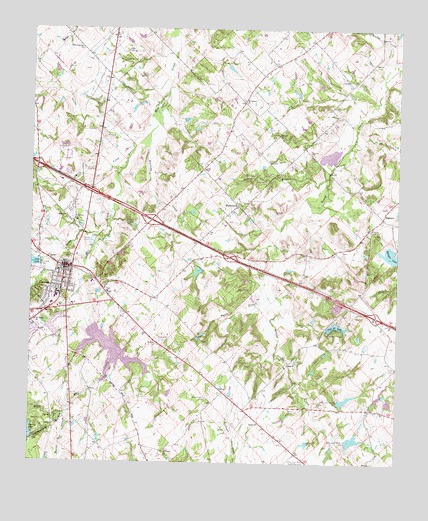
Canton, TX USGS Topographic Map
Click on map above to begin viewing in our Map Viewer.

This topographic map contains these locations and features:
Feature Name Type Latitude Longitude GNIS ID View Map
Alder BranchStreamN32.5135°W95.8647°1329337View Map
Beaver Dam BranchStreamN32.5140°W95.8633°1330270View Map
Caney CreekStreamN32.5915°W95.8408°1332090View Map
CantonPopulated PlaceN32.5565°W95.8633°1332115View Map
Canton City HallBuildingN32.5559°W95.8622°2753382View Map
Canton City Lake DamDamN32.5585°W95.8719°1862897View Map
Canton Elementary SchoolSchoolN32.5454°W95.8675°2008969View Map
Canton Fire DepartmentBuildingN32.5418°W95.8623°2655304View Map
Canton Intermediate SchoolSchoolN32.5465°W95.8661°2008971View Map
Canton Junior High SchoolSchoolN32.5471°W95.8658°2008972View Map
Canton Police DepartmentBuildingN32.5426°W95.8741°2751197View Map
Canton Post OfficePost OfficeN32.5609°W95.8741°2731701View Map
Canton-Hackney AirportAirportN32.5928°W95.8615°1386338View Map
Chinguapin BranchStreamN32.5140°W95.8633°1373090View Map
Church of Christ on Big RockChurchN32.5518°W95.8680°2024369View Map
City LakeReservoirN32.5580°W95.8747°1332867View Map
City of CantonCivilN32.5541°W95.8640°2409977View Map
Club 20 Lake DamDamN32.5385°W95.7736°1859853View Map
Club Twenty LakeReservoirN32.5401°W95.7709°1333013View Map
Dry CreekStreamN32.5676°W95.8489°1334681View Map
First Presbyterian ChurchChurchN32.5501°W95.8666°2024316View Map
Hillcrest CemeteryCemeteryN32.5587°W95.8611°1337795View Map
Kellam Number 1 DamDamN32.5185°W95.7702°1859849View Map
Kellam Number 1 LakeReservoirN32.5185°W95.7702°1859850View Map
Kellam Number 2 DamDamN32.5068°W95.7669°1859847View Map
Kellam Number 2 LakeReservoirN32.5068°W95.7669°1859848View Map
Little Hope-Moore Community CenterLocaleN32.5015°W95.7819°1340119View Map
Metzger LakeReservoirN32.5604°W95.7514°1341439View Map
Metzger Lake Number 1ReservoirN32.5604°W95.7514°1859836View Map
Moore ChurchChurchN32.5118°W95.7966°1341865View Map
Morris Chapel CemeteryCemeteryN32.5190°W95.8086°1341937View Map
Mount Lebanon ChurchChurchN32.6043°W95.8019°1342046View Map
Mount Pisgah ChurchChurchN32.5037°W95.8277°1342092View Map
Mustang CreekStreamN32.6043°W95.8289°1342307View Map
Myrtle BranchStreamN32.5521°W95.7947°1342338View Map
New Hope ChurchChurchN32.5699°W95.8602°1342472View Map
Oak Grove Baptist ChurchChurchN32.5407°W95.8736°2024366View Map
Oak Grove ChurchChurchN32.5407°W95.8733°1342969View Map
OaklandPopulated PlaceN32.5712°W95.7555°1378782View Map
Oakland CemeteryCemeteryN32.5674°W95.7600°1343018View Map
Owen LakeReservoirN32.5568°W95.8169°1859852View Map
Owen Lake DamDamN32.5568°W95.8169°1859851View Map
Red HillSummitN32.5535°W95.8500°1344928View Map
Sandy BranchStreamN32.5826°W95.7736°1346582View Map
Sandy CreekStreamN32.5926°W95.8397°1346596View Map
Soil Conservation Service Site Number 1 DamDamN32.5385°W95.8552°1862903View Map
Soil Conservation Service Site Number 1 ReservoirReservoirN32.5385°W95.8552°1862904View Map
Spring Lake DamDamN32.5068°W95.8736°1859855View Map
Starr ChurchChurchN32.5868°W95.7933°1347822View Map
Texas Department of Public Safety - Highway Patrol OfficeBuildingN32.5712°W95.8569°2751430View Map
Thompson FieldAirportN32.6160°W95.8683°2675774View Map
Van Zandt CountyCivilN32.5637°W95.8365°1384019View Map
Van Zandt County Justice CenterBuildingN32.5640°W95.8744°2738663View Map
Van Zandt County Sheriff's OfficeBuildingN32.5639°W95.8746°2751189View Map
WentworthPopulated PlaceN32.5732°W95.8058°1379252View Map
Willow Springs ChurchChurchN32.6193°W95.8580°1350222View Map
Wynn SchoolSchoolN32.5710°W95.8630°1350625View Map

Note: Coordinates in the location and feature list above are referenced to NAD83 datum.


Copyright (C) 2008-2025 Ryan Niemi / Sunset Dynamics ... All Rights Reserved