TopoQuest Logo
Do you find TopoQuest useful?
Help keep TopoQuest running and adding new maps/features by donating!
Bitcoin:  19c7KJd3qBynnjoSw5npx9KScwjBe4ifkT
Litecoin:  LXs6TkuXGGXo1vDsWCkWVdjQX94eUKd6ui
Home View Maps Find Maps Find Places Resources & Links


Mustoe, Virginia Topographic Map

USGS Map Title: Mustoe, VA
USGS Map MRC: 38079C6
DRG (GeoTIFF) Download: o38079c6.tif


Neighboring USGS Topographic Map Quads:


  Green Bank, WV  
38079D7
 

  Hightown, VA  
38079D6
 

  Monterey, VA  
38079D5
 

  Paddy Knob, WV  
38079C7
 

  Mustoe, VA  
38079C6
 

  Monterey SE, VA  
38079C5
 

  Sunrise, VA  
38079B7
 

  Burnsville, VA  
38079B6
 

  Williamsville, VA  
38079B5


Map MRC Location:

N39°
W80°
N39°
W79°
H8 H7 H6 H5 H4 H3 H2 H1
G8 G7 G6 G5 G4 G3 G2 G1
F8 F7 F6 F5 F4 F3 F2 F1
E8 E7 E6 E5 E4 E3 E2 E1
D8 D7 D6 D5 D4 D3 D2 D1
C8 C7 C6 C5 C4 C3 C2 C1
B8 B7 B6 B5 B4 B3 B2 B1
A8 A7 A6 A5 A4 A3 A2 A1
N38°
W80°
N38°
W79°

Mustoe, VA USGS 1:24K Topographic Map Preview:
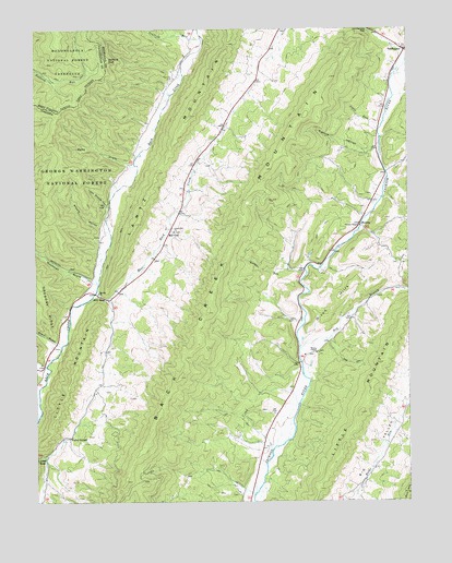
Mustoe, VA USGS Topographic Map
Click on map above to begin viewing in our Map Viewer.

This topographic map contains these locations and features:
Feature Name Type Latitude Longitude GNIS ID View Map
Back Creek MountainRidgeN38.3001°W79.6920°1481376View Map
Beulah Presbyterian ChurchChurchN38.3054°W79.7289°1481682View Map
Big ValleyBasinN38.2660°W79.6342°1481795View Map
Buckeye (historical)Populated PlaceN38.2848°W79.7478°1690053View Map
Cedar RidgeRidgeN38.3162°W79.6537°1759742View Map
Dixon HillsRidgeN38.3021°W79.6492°1483040View Map
Dry BranchStreamN38.2904°W79.6609°1483106View Map
Dry RunStreamN38.2762°W79.7489°1483145View Map
East Back CreekStreamN38.3051°W79.7301°1483196View Map
Eowyns RunStreamN38.2726°W79.7492°1848394View Map
Erwin DraftValleyN38.2920°W79.7441°1483314View Map
Fairview CemeteryCemeteryN38.3623°W79.7028°1483329View Map
Galford GapGapN38.3665°W79.7256°1483578View Map
Green Hill ChurchChurchN38.3215°W79.7028°1483803View Map
Green Hill School (historical)SchoolN38.3354°W79.6992°1673769View Map
Griffin CemeteryCemeteryN38.3129°W79.6281°1673770View Map
Jones RunStreamN38.3487°W79.6337°1484507View Map
Kettle HollowValleyN38.3428°W79.6366°1484572View Map
Lawson KnobSummitN38.3204°W79.6598°1699733View Map
Little MountainSummitN38.2837°W79.7373°1496991View Map
Little MountainSummitN38.2732°W79.6409°1487054View Map
Lynn Stand HollowValleyN38.3284°W79.7261°1485143View Map
Mill GapPopulated PlaceN38.3218°W79.7039°1497017View Map
Mill GapGapN38.3043°W79.7270°1485441View Map
MustoePopulated PlaceN38.3237°W79.6403°1497033View Map
Naples (historical)Populated PlaceN38.3693°W79.6973°1690062View Map
Plum Grove School (historical)SchoolN38.3312°W79.6370°1673778View Map
River View School (historical)SchoolN38.2554°W79.6837°1673779View Map
Riverview Church (historical)ChurchN38.2554°W79.6837°1673780View Map
Ruckman DraftValleyN38.3082°W79.7312°1486809View Map
Scaffold RunStreamN38.3729°W79.6934°1486959View Map
Sheets HollowValleyN38.3226°W79.7278°1487170View Map
Siebert RunStreamN38.3615°W79.7001°1690063View Map
Stark RidgeRidgeN38.3179°W79.6609°1781929View Map
Sues DraftValleyN38.3389°W79.7181°1487684View Map
Townsend DraftValleyN38.2846°W79.7474°1487971View Map
Valley CenterLocaleN38.2673°W79.7389°1488083View Map
VanderpoolPopulated PlaceN38.3696°W79.6253°1497187View Map
Victory ChapelChurchN38.3229°W79.6406°1488130View Map
Vinegar RunStreamN38.3112°W79.6595°1488134View Map
Warwick RunStreamN38.2862°W79.7464°1690054View Map
Wesley ChapelChurchN38.2896°W79.6556°1488236View Map
Woods-Terry School (historical)SchoolN38.2985°W79.6628°1673782View Map

Note: Coordinates in the location and feature list above are referenced to NAD83 datum.


Copyright (C) 2008-2025 Ryan Niemi / Sunset Dynamics ... All Rights Reserved