TopoQuest Logo
Do you find TopoQuest useful?
Help keep TopoQuest running and adding new maps/features by donating!
Bitcoin:  19c7KJd3qBynnjoSw5npx9KScwjBe4ifkT
Litecoin:  LXs6TkuXGGXo1vDsWCkWVdjQX94eUKd6ui
Home View Maps Find Maps Find Places Resources & Links


Paddy Knob, West Virginia Topographic Map

USGS Map Title: Paddy Knob, WV
USGS Map MRC: 38079C7
DRG (GeoTIFF) Download: o38079c7.tif


Neighboring USGS Topographic Map Quads:


  Cass, WV  
38079D8
 

  Green Bank, WV  
38079D7
 

  Hightown, VA  
38079D6
 

  Clover Lick, WV  
38079C8
 

  Paddy Knob, WV  
38079C7
 

  Mustoe, VA  
38079C6
 

  Minnehaha Springs, WV  
38079B8
 

  Sunrise, VA  
38079B7
 

  Burnsville, VA  
38079B6


Map MRC Location:

N39°
W80°
N39°
W79°
H8 H7 H6 H5 H4 H3 H2 H1
G8 G7 G6 G5 G4 G3 G2 G1
F8 F7 F6 F5 F4 F3 F2 F1
E8 E7 E6 E5 E4 E3 E2 E1
D8 D7 D6 D5 D4 D3 D2 D1
C8 C7 C6 C5 C4 C3 C2 C1
B8 B7 B6 B5 B4 B3 B2 B1
A8 A7 A6 A5 A4 A3 A2 A1
N38°
W80°
N38°
W79°

Paddy Knob, WV USGS 1:24K Topographic Map Preview:
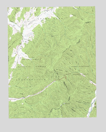
Paddy Knob, WV USGS Topographic Map
Click on map above to begin viewing in our Map Viewer.

This topographic map contains these locations and features:
Feature Name Type Latitude Longitude GNIS ID View Map
Bear HollowValleyN38.2975°W79.7902°1481521View Map
Big Crooked RidgeRidgeN38.3018°W79.7992°1481720View Map
Big EndRidgeN38.2910°W79.7709°1481724View Map
Big RidgeRidgeN38.3104°W79.7681°1481771View Map
Bird RunStreamN38.2735°W79.8528°1550366View Map
Bird Run CampgroundLocaleN38.2718°W79.8534°1553602View Map
Bridge HollowValleyN38.2660°W79.7567°1481987View Map
Brushy RidgeRidgeN38.2771°W79.7642°1482080View Map
Bussard CemeteryCemeteryN38.3179°W79.8581°1550571View Map
Buzzard CemeteryCemeteryN38.3287°W79.8573°1550573View Map
Buzzard CemeteryCemeteryN38.3371°W79.8495°1550574View Map
Camp Copperhead (historical)LocaleN38.2712°W79.8534°1728024View Map
Campground HollowValleyN38.2559°W79.7616°1482292View Map
Charley RidgeRidgeN38.3740°W79.8484°1550674View Map
Chestnut RidgeRidgeN38.3621°W79.7764°1550697View Map
Chestnut RidgeRidgeN38.3471°W79.8728°1550700View Map
Chocklett SpringSpringN38.3182°W79.8609°1558076View Map
Dilly CemeteryCemeteryN38.3376°W79.8464°1550927View Map
Dunmore SpringSpringN38.3557°W79.8678°1558088View Map
Galford RunStreamN38.3504°W79.8473°1551195View Map
Garfield Grimes SpringSpringN38.3404°W79.8498°1558094View Map
Gragg CemeteryCemeteryN38.2973°W79.8712°1551264View Map
Gregory RidgeRidgeN38.3257°W79.7589°1483834View Map
Gum BranchStreamN38.3571°W79.8656°1551310View Map
Gum Spring School (historical)SchoolN38.3726°W79.8401°1728076View Map
Hillside School (historical)SchoolN38.3523°W79.8559°1728083View Map
Jakes RunStreamN38.3576°W79.8292°1551562View Map
Kent Simmons HollowValleyN38.2631°W79.7572°1484558View Map
Left Prong Galford RunStreamN38.3718°W79.7731°1551777View Map
Lick DraftValleyN38.3003°W79.7737°1484819View Map
Lick PointsRidgeN38.3257°W79.7870°1484825View Map
Lindsay CemeteryCemeteryN38.3234°W79.8656°1551816View Map
Little RidgeRidgeN38.3076°W79.7920°1484963View Map
Lower GapGapN38.2626°W79.7509°1485117View Map
Lower MountainSummitN38.3687°W79.8631°1551961View Map
Mad Sheep RidgeRidgeN38.2601°W79.8526°1551985View Map
Meadow SpringSpringN38.3571°W79.8678°1558133View Map
Moore CemeteryCemeteryN38.3140°W79.8659°1552177View Map
Mount Pleasant School (historical)SchoolN38.3285°W79.8612°1728124View Map
New Hope ChurchChurchN38.3337°W79.8570°1552298View Map
Paddy KnobSummitN38.2657°W79.7959°1486028View Map
Paddy Knob Lookout TowerTowerN38.2660°W79.7959°1728135View Map
Paddy Knob TrailTrailN38.2646°W79.8209°1553600View Map
Pine RidgeRidgeN38.2843°W79.7645°1486224View Map
Shinaberry CemeteryCemeteryN38.3234°W79.8514°1552868View Map
Shock RunStreamN38.3435°W79.8542°1552876View Map
Slate Lick KnobSummitN38.2773°W79.8531°1552921View Map
Sorrel Point RidgeRidgeN38.3168°W79.7831°1487385View Map
Steep Pinch RidgeRidgeN38.3093°W79.7856°1487551View Map
Stony RunStreamN38.3696°W79.8137°1553082View Map
Thorny BranchStreamN38.3504°W79.8473°1553223View Map
Wesley ChapelChurchN38.3710°W79.8181°1553405View Map
Wesley Chapel School (historical)SchoolN38.3701°W79.8195°1728194View Map

Note: Coordinates in the location and feature list above are referenced to NAD83 datum.


Copyright (C) 2008-2024 Ryan Niemi / Sunset Dynamics ... All Rights Reserved