TopoQuest Logo
Do you find TopoQuest useful?
Help keep TopoQuest running and adding new maps/features by donating!
Bitcoin:  19c7KJd3qBynnjoSw5npx9KScwjBe4ifkT
Litecoin:  LXs6TkuXGGXo1vDsWCkWVdjQX94eUKd6ui
Home View Maps Find Maps Find Places Resources & Links


Greenville West, Pennsylvania Topographic Map

USGS Map Title: Greenville West, PA
USGS Map MRC: 41080D4
DRG (GeoTIFF) Download: o41080d4.tif


Neighboring USGS Topographic Map Quads:


  Andover, OH  
41080E5
 

  Hartstown, PA  
41080E4
 

  Conneaut Lake, PA  
41080E3
 

  Kinsman, OH  
41080D5
 

  Greenville West, PA  
41080D4
 

  Greenville East, PA  
41080D3
 

  Orangeville, OH  
41080C5
 

  Sharpsville, PA  
41080C4
 

  Fredonia, PA  
41080C3


Map MRC Location:

N42°
W81°
N42°
W80°
H8 H7 H6 H5 H4 H3 H2 H1
G8 G7 G6 G5 G4 G3 G2 G1
F8 F7 F6 F5 F4 F3 F2 F1
E8 E7 E6 E5 E4 E3 E2 E1
D8 D7 D6 D5 D4 D3 D2 D1
C8 C7 C6 C5 C4 C3 C2 C1
B8 B7 B6 B5 B4 B3 B2 B1
A8 A7 A6 A5 A4 A3 A2 A1
N41°
W81°
N41°
W80°

Greenville West, PA USGS 1:24K Topographic Map Preview:
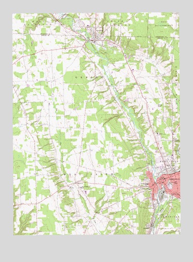
Greenville West, PA USGS Topographic Map
Click on map above to begin viewing in our Map Viewer.

This topographic map contains these locations and features:
Feature Name Type Latitude Longitude GNIS ID View Map
Artman SchoolSchoolN41.4303°W80.4720°1205328View Map
Borough of GreenvilleCivilN41.4051°W80.3838°1215439View Map
Borough of JamestownCivilN41.4843°W80.4370°1215443View Map
Columbia SchoolSchoolN41.4045°W80.3787°1199850View Map
Donner CrossroadsPopulated PlaceN41.4278°W80.3803°1199857View Map
GreenvillePopulated PlaceN41.4045°W80.3912°1213969View Map
Greenville Municipal AirportAirportN41.4460°W80.3941°1194235View Map
Greenville Police DepartmentBuildingN41.4041°W80.3912°2777111View Map
Greenville Post OfficePost OfficeN41.4042°W80.3881°2779794View Map
Greenville Volunteer Fire DepartmentBuildingN41.4045°W80.3807°2645140View Map
Holsing Airport (historical)AirportN41.4834°W80.4831°1194240View Map
JamestownPopulated PlaceN41.4848°W80.4376°1199885View Map
Jamestown Borough Police DepartmentBuildingN41.4861°W80.4368°2780535View Map
Jamestown Post OfficePost OfficeN41.4844°W80.4411°2779863View Map
Jamestown Volunteer Fire Department Station 89BuildingN41.4856°W80.4371°2645083View Map
Little Shenango RiverStreamN41.4056°W80.3928°1199898View Map
Mathay RunStreamN41.3887°W80.3912°1199122View Map
MaysvillePopulated PlaceN41.4045°W80.4526°1199904View Map
Mud CollegeSchoolN41.4520°W80.3928°1205327View Map
Park Lawn CemeteryCemeteryN41.4864°W80.4481°1199931View Map
Penn High SchoolSchoolN41.4064°W80.3865°1199932View Map
Pymatuning ReservoirReservoirN41.4984°W80.4615°1044806View Map
Pymatuning Reservoir DamDamN41.4984°W80.4615°1195626View Map
Ray SchoolSchoolN41.4512°W80.4509°1205326View Map
Rocky Glen CemeteryCemeteryN41.4998°W80.3758°1199951View Map
Saint Michaels CemeteryCemeteryN41.4050°W80.3992°1199954View Map
Saint Pauls Childrens HomeBuildingN41.4320°W80.3915°1199955View Map
Saul RunStreamN41.3939°W80.3837°1199958View Map
ShenangoPopulated PlaceN41.3798°W80.3990°1199970View Map
Shenango Valley CemeteryCemeteryN41.4120°W80.3795°1199972View Map
Sugar RunStreamN41.4970°W80.4612°1199988View Map
Sugar Run SchoolSchoolN41.4912°W80.4826°1205329View Map
Thiel CollegeSchoolN41.4137°W80.3842°1199992View Map
Township of GreeneCivilN41.4644°W80.4519°1216800View Map
Township of West SalemCivilN41.4026°W80.4551°1216822View Map
Walnut Creek Golf CourseLocaleN41.4959°W80.4445°1206559View Map
West Salem Elementary SchoolSchoolN41.4017°W80.4490°1213939View Map
West Salem Volunteer Fire Department Station 73BuildingN41.4038°W80.4560°2645348View Map
West Salem Volunteer Fire Department Station 73-2BuildingN41.4277°W80.3864°2645341View Map
West Side SchoolSchoolN41.4051°W80.3992°1200000View Map
WGRP-AM (Greenville)TowerN41.3862°W80.4095°1200499View Map
WGRP-FM (Greenville)TowerN41.3862°W80.4095°1210242View Map
WTGP-FM (Greenville)TowerN41.4142°W80.3803°1200307View Map

Note: Coordinates in the location and feature list above are referenced to NAD83 datum.


Copyright (C) 2008-2025 Ryan Niemi / Sunset Dynamics ... All Rights Reserved