TopoQuest Logo
Do you find TopoQuest useful?
Help keep TopoQuest running and adding new maps/features by donating!
Bitcoin:  19c7KJd3qBynnjoSw5npx9KScwjBe4ifkT
Litecoin:  LXs6TkuXGGXo1vDsWCkWVdjQX94eUKd6ui
Home View Maps Find Maps Find Places Resources & Links


Sharpsville, Pennsylvania Topographic Map

USGS Map Title: Sharpsville, PA
USGS Map MRC: 41080C4
DRG (GeoTIFF) Download: o41080c4.tif


Neighboring USGS Topographic Map Quads:


  Kinsman, OH  
41080D5
 

  Greenville West, PA  
41080D4
 

  Greenville East, PA  
41080D3
 

  Orangeville, OH  
41080C5
 

  Sharpsville, PA  
41080C4
 

  Fredonia, PA  
41080C3
 

  Sharon West, PA  
41080B5
 

  Sharon East, PA  
41080B4
 

  Greenfield, PA  
41080B3


Map MRC Location:

N42°
W81°
N42°
W80°
H8 H7 H6 H5 H4 H3 H2 H1
G8 G7 G6 G5 G4 G3 G2 G1
F8 F7 F6 F5 F4 F3 F2 F1
E8 E7 E6 E5 E4 E3 E2 E1
D8 D7 D6 D5 D4 D3 D2 D1
C8 C7 C6 C5 C4 C3 C2 C1
B8 B7 B6 B5 B4 B3 B2 B1
A8 A7 A6 A5 A4 A3 A2 A1
N41°
W81°
N41°
W80°

Sharpsville, PA USGS 1:24K Topographic Map Preview:
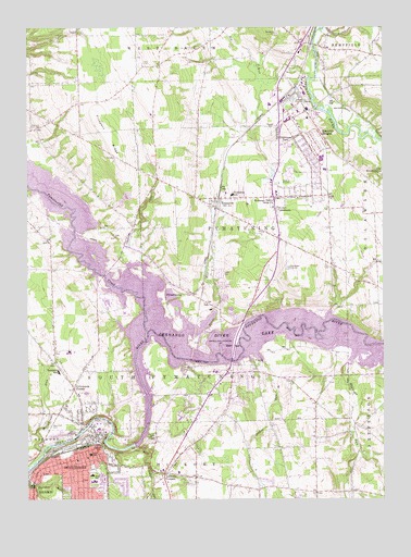
Sharpsville, PA USGS Topographic Map
Click on map above to begin viewing in our Map Viewer.

This topographic map contains these locations and features:
Feature Name Type Latitude Longitude GNIS ID View Map
Bethel TabernacleChurchN41.3276°W80.4109°1169411View Map
Big RunStreamN41.3614°W80.4001°1192139View Map
Birchwood Golf CourseLocaleN41.3076°W80.4220°1205593View Map
Borough of ClarkCivilN41.2831°W80.4088°1215436View Map
Borough of SharpsvilleCivilN41.2595°W80.4812°1215448View Map
Brush RunStreamN41.3001°W80.4334°1170455View Map
Chestnut RunStreamN41.3126°W80.4653°1171753View Map
ClarkPopulated PlaceN41.2862°W80.4276°1171904View Map
Clark Post OfficePost OfficeN41.2832°W80.4262°2779862View Map
Clark Volunteer Fire Company Station 99BuildingN41.2773°W80.4172°2645251View Map
Deeter SchoolSchoolN41.2637°W80.4742°1173110View Map
Edgewood Surgical HospitalHospitalN41.3307°W80.4183°2718116View Map
Fell CemeteryCemeteryN41.3659°W80.4576°1174664View Map
Golden RunStreamN41.2862°W80.4165°1175784View Map
Good Hope CemeteryCemeteryN41.3737°W80.4040°1205334View Map
Greencrest ParkPopulated PlaceN41.3459°W80.4051°1176142View Map
Keystone SchoolSchoolN41.3062°W80.4459°1205333View Map
Lamonts CornersPopulated PlaceN41.2570°W80.4512°1178834View Map
Linn SchoolSchoolN41.2562°W80.4095°1205332View Map
Magargee RunStreamN41.2851°W80.3881°1180190View Map
Mahaney Public Use AreaParkN41.2703°W80.4598°1207567View Map
McCullough RunStreamN41.2623°W80.4945°1043098View Map
McCullough RunStreamN41.2623°W80.4945°1180680View Map
Napodano AirportAirportN41.3335°W80.4232°1194212View Map
Pebly SchoolSchoolN41.2564°W80.4767°1183433View Map
Pine Hollow RunStreamN41.2639°W80.4606°1183846View Map
Pleasant Valley SchoolSchoolN41.3239°W80.4612°1205331View Map
Pritchards CornerPopulated PlaceN41.2795°W80.4834°1184430View Map
Prospect RidgeRidgeN41.3467°W80.4715°1184458View Map
PymatuningLocaleN41.3045°W80.4431°1214221View Map
Pymatuning CreekStreamN41.2945°W80.4573°1066913View Map
Pymatuning Township Police DepartmentBuildingN41.3297°W80.4153°2780178View Map
Reichard CemeteryCemeteryN41.3487°W80.4981°1184868View Map
Reynolds HeightsPopulated PlaceN41.3451°W80.3942°1184968View Map
Reynolds Heights Census Designated PlaceCensusN41.3432°W80.4033°2633823View Map
Reynolds PlazaLocaleN41.3312°W80.4123°1211658View Map
River Road LandfillLocaleN41.2672°W80.4889°2725976View Map
Sharpesville Post OfficePost OfficeN41.2652°W80.4750°2779796View Map
SharpsvillePopulated PlaceN41.2592°W80.4720°1193330View Map
Sharpsville Boro Police DepartmentBuildingN41.2634°W80.4754°2777066View Map
Sharpsville Volunteer Fire DepartmentBuildingN41.2632°W80.4791°2645079View Map
Shenango Public Use AreaParkN41.2889°W80.4381°1207665View Map
Shenango River DamDamN41.2651°W80.4631°1195421View Map
Shenango River LakeReservoirN41.2923°W80.4231°1046181View Map
Shenango Valley Bible ChurchChurchN41.3281°W80.4128°1187464View Map
Simpkins SchoolSchoolN41.3712°W80.4934°1205330View Map
South Pymatuning Township Police DepartmentBuildingN41.2813°W80.4861°2780589View Map
South Pymatuning Township Volunteer Fire Department Station 78BuildingN41.2822°W80.4868°2645823View Map
Township of PymatuningCivilN41.3269°W80.4246°1216814View Map
Township of South PymatuningCivilN41.3112°W80.4855°1216819View Map
TransferPopulated PlaceN41.3289°W80.4328°1189717View Map
Transfer Post OfficePost OfficeN41.3312°W80.4124°2775125View Map
Transfer Volunteer Fire Department Station 75-1BuildingN41.3287°W80.4348°2645306View Map
Transfer Volunteer Fire Department Station 75-2BuildingN41.3330°W80.4042°2645574View Map
Victory StationLocaleN41.3592°W80.4056°1212204View Map
Zahniser WoodsWoodsN41.2668°W80.4692°2729349View Map
Zion CemeteryCemeteryN41.3118°W80.3933°1191966View Map

Note: Coordinates in the location and feature list above are referenced to NAD83 datum.


Copyright (C) 2008-2024 Ryan Niemi / Sunset Dynamics ... All Rights Reserved