TopoQuest Logo
Do you find TopoQuest useful?
Help keep TopoQuest running and adding new maps/features by donating!
Bitcoin:  19c7KJd3qBynnjoSw5npx9KScwjBe4ifkT
Litecoin:  LXs6TkuXGGXo1vDsWCkWVdjQX94eUKd6ui
Home View Maps Find Maps Find Places Resources & Links


Greenwood Springs, Mississippi Topographic Map

USGS Map Title: Greenwood Springs, MS
USGS Map MRC: 33088H3
DRG (GeoTIFF) Download: o33088h3.tif


Neighboring USGS Topographic Map Quads:


  Smithville, MS  
34088A4
 

  Turon, MS  
34088A3
 

  Detroit, AL  
34088A2
 

  Amory, MS  
33088H4
 

  Greenwood Springs, MS  
33088H3
 

  Sulligent, AL  
33088H2
 

  Amory SW, MS  
33088G4
 

  Amory SE, MS  
33088G3
 

  Sulligent SW, AL  
33088G2


Map MRC Location:

N34°
W89°
N34°
W88°
H8 H7 H6 H5 H4 H3 H2 H1
G8 G7 G6 G5 G4 G3 G2 G1
F8 F7 F6 F5 F4 F3 F2 F1
E8 E7 E6 E5 E4 E3 E2 E1
D8 D7 D6 D5 D4 D3 D2 D1
C8 C7 C6 C5 C4 C3 C2 C1
B8 B7 B6 B5 B4 B3 B2 B1
A8 A7 A6 A5 A4 A3 A2 A1
N33°
W89°
N33°
W88°

Greenwood Springs, MS USGS 1:24K Topographic Map Preview:
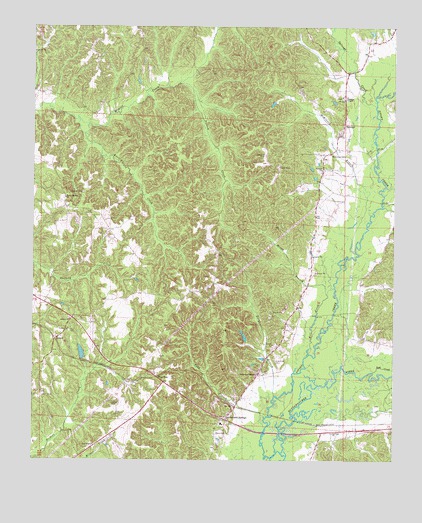
Greenwood Springs, MS USGS Topographic Map
Click on map above to begin viewing in our Map Viewer.

This topographic map contains these locations and features:
Feature Name Type Latitude Longitude GNIS ID View Map
Baker CemeteryCemeteryN33.8829°W88.3114°666468View Map
Boggan CemeteryCemeteryN33.9520°W88.3578°667366View Map
Cauhorn (historical)Populated PlaceN33.8854°W88.2731°709322View Map
Center CemeteryCemeteryN33.8907°W88.3475°668231View Map
Crenshaw CemeteryCemeteryN33.9037°W88.2906°668942View Map
DePriest Free Will Baptist ChurchChurchN33.8829°W88.2709°669161View Map
Durgan BranchStreamN33.8940°W88.2911°669526View Map
Gibbs Box (historical)LocaleN33.9787°W88.2781°687407View Map
Greenwood SpringsPopulated PlaceN33.8871°W88.3089°670727View Map
Greenwood Springs Baptist ChurchChurchN33.8926°W88.3023°709343View Map
Greenwood Springs Post OfficePost OfficeN33.8864°W88.3077°2768867View Map
Greenwood Springs SchoolSchoolN33.8857°W88.3095°709344View Map
Greenwood Springs United Methodist ChurchChurchN33.9004°W88.2964°670728View Map
Kinney CreekStreamN33.9712°W88.3562°672180View Map
Lann CemeteryCemeteryN33.9595°W88.2898°672306View Map
Lost CreekStreamN33.9007°W88.2567°152159View Map
McKinney BranchStreamN33.9351°W88.2631°673385View Map
McKinney CemeteryCemeteryN33.9629°W88.2720°673386View Map
Mill CreekStreamN33.9054°W88.2798°673608View Map
Minga BranchStreamN33.9234°W88.2731°673674View Map
New Hope ChurchChurchN33.8790°W88.3528°674726View Map
Possum CreekStreamN33.9834°W88.3245°676269View Map
QuincyPopulated PlaceN33.9098°W88.3670°692163View Map
Quincy ChurchChurchN33.9154°W88.3623°676435View Map
Riggan ChapelChurchN33.9801°W88.2664°676662View Map
Rocky Springs ChurchChurchN33.9507°W88.3639°676807View Map
SplungePopulated PlaceN33.9690°W88.2686°678059View Map
Splunge Baptist ChurchChurchN33.9590°W88.2748°678060View Map
Splunge CreekStreamN33.9776°W88.2564°678062View Map
Splunge Volunteer Fire DepartmentBuildingN33.9818°W88.2677°2665639View Map
Supervisor District 2CivilN33.9324°W88.3592°711988View Map
Todd BranchStreamN33.8846°W88.2939°678794View Map
Trinity Baptist ChurchChurchN33.9126°W88.3625°678886View Map
Wise GapPopulated PlaceN33.8990°W88.3317°692328View Map

Note: Coordinates in the location and feature list above are referenced to NAD83 datum.


Copyright (C) 2008-2025 Ryan Niemi / Sunset Dynamics ... All Rights Reserved