TopoQuest Logo
Do you find TopoQuest useful?
Help keep TopoQuest running and adding new maps/features by donating!
Bitcoin:  19c7KJd3qBynnjoSw5npx9KScwjBe4ifkT
Litecoin:  LXs6TkuXGGXo1vDsWCkWVdjQX94eUKd6ui
Home View Maps Find Maps Find Places Resources & Links


Sulligent, Alabama Topographic Map

USGS Map Title: Sulligent, AL
USGS Map MRC: 33088H2
DRG (GeoTIFF) Download: o33088h2.tif


Neighboring USGS Topographic Map Quads:


  Turon, MS  
34088A3
 

  Detroit, AL  
34088A2
 

  Henson Springs, AL  
34088A1
 

  Greenwood Springs, MS  
33088H3
 

  Sulligent, AL  
33088H2
 

  Beaverton, AL  
33088H1
 

  Amory SE, MS  
33088G3
 

  Sulligent SW, AL  
33088G2
 

  Vernon, AL  
33088G1


Map MRC Location:

N34°
W89°
N34°
W88°
H8 H7 H6 H5 H4 H3 H2 H1
G8 G7 G6 G5 G4 G3 G2 G1
F8 F7 F6 F5 F4 F3 F2 F1
E8 E7 E6 E5 E4 E3 E2 E1
D8 D7 D6 D5 D4 D3 D2 D1
C8 C7 C6 C5 C4 C3 C2 C1
B8 B7 B6 B5 B4 B3 B2 B1
A8 A7 A6 A5 A4 A3 A2 A1
N33°
W89°
N33°
W88°

Sulligent, AL USGS 1:24K Topographic Map Preview:
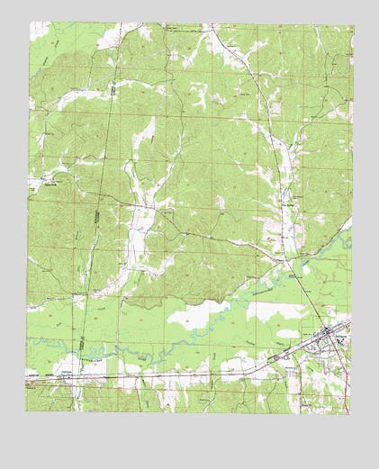
Sulligent, AL USGS Topographic Map
Click on map above to begin viewing in our Map Viewer.

This topographic map contains these locations and features:
Feature Name Type Latitude Longitude GNIS ID View Map
Almon CemeteryCemeteryN33.9776°W88.1686°113042View Map
Blaylock CemeteryCemeteryN33.9137°W88.2245°114487View Map
Bogue CreekStreamN33.9104°W88.1645°114672View Map
Brown StadiumParkN33.8972°W88.1286°2352831View Map
Center Point ChurchChurchN33.9490°W88.2409°668245View Map
Church of GodChurchN33.8784°W88.1436°116144View Map
City of SulligentCivilN33.8912°W88.1266°2405539View Map
Evans CemeteryCemeteryN33.9393°W88.1981°118067View Map
GattmanPopulated PlaceN33.8854°W88.2353°670338View Map
Gattman Baptist ChurchChurchN33.8834°W88.2325°709337View Map
Gattman Holiness ChurchChurchN33.8826°W88.2495°671290View Map
Gattman Post OfficePost OfficeN33.8852°W88.2347°2768651View Map
Gattman United Methodist ChurchChurchN33.8859°W88.2334°709338View Map
Hollis CemeteryCemeteryN33.8854°W88.1661°120258View Map
Indian CreekStreamN33.8976°W88.1773°120650View Map
Lost Creek (historical)LocaleN33.9982°W88.1986°132782View Map
Macedonia CemeteryCemeteryN33.8901°W88.1459°132784View Map
Macedonia Primitive Baptist ChurchChurchN33.8896°W88.1461°152189View Map
Moors CreekStreamN33.8907°W88.2017°123035View Map
Otter BranchStreamN33.9073°W88.2267°124321View Map
Pickle CemeteryCemeteryN33.9462°W88.2470°675712View Map
Pine SpringsPopulated PlaceN33.9429°W88.1523°156895View Map
Pine Springs CemeteryCemeteryN33.9445°W88.1484°124840View Map
Pine Springs CreekStreamN33.9221°W88.1448°152934View Map
Pine Springs Methodist ChurchChurchN33.9432°W88.1534°132796View Map
Ray CemeteryCemeteryN33.9545°W88.2339°676501View Map
Sandlin CemeteryCemeteryN33.9243°W88.1514°126356View Map
Shiloh ChurchChurchN33.9229°W88.2117°126750View Map
Sipsey ForkPopulated PlaceN33.9493°W88.2436°677852View Map
SulligentPopulated PlaceN33.9018°W88.1345°153600View Map
Sulligent CemeteryCemeteryN33.8979°W88.1270°158477View Map
Sulligent High SchoolSchoolN33.8981°W88.1297°132802View Map
Sulligent Police DepartmentBuildingN33.9014°W88.1333°2751923View Map
Sulligent Post OfficePost OfficeN33.8995°W88.1324°166647View Map
Sulligent Volunteer Fire DepartmentBuildingN33.9014°W88.1332°2683307View Map
Turkey CreekStreamN33.8973°W88.1856°128162View Map
Village of GattmanCivilN33.8848°W88.2366°2407461View Map
Watson CreekStreamN33.8923°W88.2286°128644View Map
Wesley Chapel CemeteryCemeteryN33.9990°W88.1978°158481View Map
Wesley Chapel Gas FieldOilfieldN33.9932°W88.1945°154855View Map
Wesley Chapel Methodist ChurchChurchN33.9984°W88.1975°153931View Map

Note: Coordinates in the location and feature list above are referenced to NAD83 datum.


Copyright (C) 2008-2025 Ryan Niemi / Sunset Dynamics ... All Rights Reserved