TopoQuest Logo
Do you find TopoQuest useful?
Help keep TopoQuest running and adding new maps/features by donating!
Bitcoin:  19c7KJd3qBynnjoSw5npx9KScwjBe4ifkT
Litecoin:  LXs6TkuXGGXo1vDsWCkWVdjQX94eUKd6ui
Home View Maps Find Maps Find Places Resources & Links


Melbourne, Arkansas Topographic Map

USGS Map Title: Melbourne, AR
USGS Map MRC: 36091A8
DRG (GeoTIFF) Download: o36091a8.tif


Neighboring USGS Topographic Map Quads:


  Pineville, AR  
36092B1
 

  Oxford, AR  
36091B8
 

  Franklin, AR  
36091B7
 

  Boswell, AR  
36092A1
 

  Melbourne, AR  
36091A8
 

  Zion, AR  
36091A7
 

  Sylamore, AR  
35092H1
 

  Guion, AR  
35091H8
 

  Mount Pleasant, AR  
35091H7


Map MRC Location:

N37°
W92°
N37°
W91°
H8 H7 H6 H5 H4 H3 H2 H1
G8 G7 G6 G5 G4 G3 G2 G1
F8 F7 F6 F5 F4 F3 F2 F1
E8 E7 E6 E5 E4 E3 E2 E1
D8 D7 D6 D5 D4 D3 D2 D1
C8 C7 C6 C5 C4 C3 C2 C1
B8 B7 B6 B5 B4 B3 B2 B1
A8 A7 A6 A5 A4 A3 A2 A1
N36°
W92°
N36°
W91°

Melbourne, AR USGS 1:24K Topographic Map Preview:
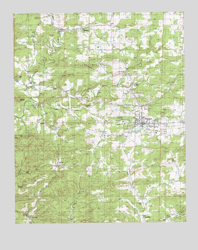
Melbourne, AR USGS Topographic Map
Click on map above to begin viewing in our Map Viewer.

This topographic map contains these locations and features:
Feature Name Type Latitude Longitude GNIS ID View Map
Arkansas Emergency Transport - MelbourneBuildingN36.0598°W91.8879°2119184View Map
Bald MountainSummitN36.0873°W91.9640°57316View Map
Band Mill CreekStreamN36.1142°W91.9665°46068View Map
BelviewPopulated PlaceN36.0903°W91.9196°57357View Map
Belview Baptist ChurchChurchN36.0792°W91.9151°65853View Map
Bethel ChurchChurchN36.0031°W91.8907°46459View Map
Big Hurricane CreekStreamN36.0676°W91.9613°46572View Map
Bigham CemeteryCemeteryN36.0670°W91.8882°65856View Map
Brushy RidgeRidgeN36.0937°W91.9488°47090View Map
Byler HillSummitN36.0876°W91.9979°57486View Map
City of MelbourneCivilN36.0574°W91.8875°2405065View Map
Combs CemeteryCemeteryN36.0520°W91.9346°76657View Map
Haley CreekStreamN36.0103°W91.9057°49768View Map
Hunters MountainSummitN36.0748°W91.9979°50421View Map
Izard CountyCivilN36.0949°W91.9134°66860View Map
Izard County Sheriff's OfficeBuildingN36.0585°W91.9180°2118628View Map
Jones CemeteryCemeteryN36.0945°W91.9185°65879View Map
JumboPopulated PlaceN36.0601°W91.9796°50759View Map
Knob CreekPopulated PlaceN36.0842°W91.9882°58024View Map
Knob CreekStreamN36.0706°W91.9846°50899View Map
Lawrence CemeteryCemeteryN36.0815°W91.9113°65880View Map
Little Hurricane CreekStreamN36.0823°W91.9246°51285View Map
Lone StarPopulated PlaceN36.0037°W91.9899°57095View Map
LunenburgPopulated PlaceN36.0026°W91.9076°77564View Map
Lunenburg CemeteryCemeteryN36.0115°W91.9071°65883View Map
Mayfield CemeteryCemeteryN36.0765°W91.9168°65884View Map
MelbournePopulated PlaceN36.0595°W91.9085°77643View Map
Melbourne Elementary SchoolSchoolN36.0612°W91.9080°65885View Map
Melbourne High SchoolSchoolN36.0616°W91.9107°65886View Map
Melbourne Volunteer Fire DepartmentBuildingN36.0623°W91.9048°2116787View Map
NewburgPopulated PlaceN36.1156°W91.9499°77843View Map
Ozarka Vocational Technical SchoolSchoolN36.0531°W91.8963°65899View Map
Page CemeteryCemeteryN36.1048°W91.9404°53128View Map
Powell SpringSpringN36.0562°W91.9049°65905View Map
Red Hill ChurchChurchN36.0759°W91.9565°53951View Map
Smith CemeteryCemeteryN36.0006°W91.8913°65914View Map
Township of LunenburgCivilN36.0027°W91.9417°66706View Map
Township of Mill CreekCivilN36.0617°W91.9112°66707View Map
White Oak BranchStreamN36.0603°W91.9449°65920View Map

Note: Coordinates in the location and feature list above are referenced to NAD83 datum.


Copyright (C) 2008-2024 Ryan Niemi / Sunset Dynamics ... All Rights Reserved