TopoQuest Logo
Do you find TopoQuest useful?
Help keep TopoQuest running and adding new maps/features by donating!
Bitcoin:  19c7KJd3qBynnjoSw5npx9KScwjBe4ifkT
Litecoin:  LXs6TkuXGGXo1vDsWCkWVdjQX94eUKd6ui
Home View Maps Find Maps Find Places Resources & Links


Guyton, Georgia Topographic Map

USGS Map Title: Guyton, GA
USGS Map MRC: 32081C4
DRG (GeoTIFF) Download: o32081c4.tif


Neighboring USGS Topographic Map Quads:


  Leefield, GA  
32081D5
 

  Egypt, GA  
32081D4
 

  Springfield North, GA  
32081D3
 

  Stilson, GA  
32081C5
 

  Guyton, GA  
32081C4
 

  Springfield South, GA  
32081C3
 

  Lanier, GA  
32081B5
 

  Eden, GA  
32081B4
 

  Meldrim, GA  
32081B3


Map MRC Location:

N33°
W82°
N33°
W81°
H8 H7 H6 H5 H4 H3 H2 H1
G8 G7 G6 G5 G4 G3 G2 G1
F8 F7 F6 F5 F4 F3 F2 F1
E8 E7 E6 E5 E4 E3 E2 E1
D8 D7 D6 D5 D4 D3 D2 D1
C8 C7 C6 C5 C4 C3 C2 C1
B8 B7 B6 B5 B4 B3 B2 B1
A8 A7 A6 A5 A4 A3 A2 A1
N32°
W82°
N32°
W81°

Guyton, GA USGS 1:24K Topographic Map Preview:
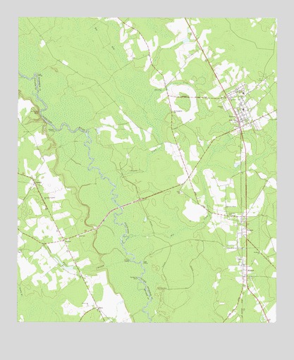
Guyton, GA USGS Topographic Map
Click on map above to begin viewing in our Map Viewer.

This topographic map contains these locations and features:
Feature Name Type Latitude Longitude GNIS ID View Map
Alderman LandingLocaleN32.3285°W81.4818°331013View Map
Big BaySwampN32.3663°W81.4582°311295View Map
Blue LakeSwampN32.2508°W81.4362°350291View Map
Briggs FieldAirportN32.3213°W81.4252°2442671View Map
Captain William Cone BridgeBridgeN32.2974°W81.4504°350310View Map
City of GuytonCivilN32.3358°W81.3926°2403777View Map
Cone CemeteryCemeteryN32.2852°W81.4709°312888View Map
Doctor Floyd BridgeBridgeN32.2927°W81.4576°350329View Map
Duck LakeSwampN32.2916°W81.4543°350331View Map
Elkins CemeteryCemeteryN32.3035°W81.4207°313908View Map
Ferguson CemeteryCemeteryN32.3389°W81.4005°314106View Map
GuytonPopulated PlaceN32.3363°W81.3915°356129View Map
Guyton Christian ChurchChurchN32.3336°W81.3923°2502795View Map
Guyton Elementary SchoolSchoolN32.3396°W81.3990°350229View Map
Guyton Historic DistrictParkN32.3352°W81.3912°350230View Map
Guyton Police DepartmentBuildingN32.3375°W81.3911°2733500View Map
Guyton Post OfficePost OfficeN32.3386°W81.3972°350231View Map
Guyton Town HallBuildingN32.3332°W81.3915°350232View Map
Guyton United Methodist ChurchChurchN32.3354°W81.3918°2502905View Map
Guyton Volunteer Fire DepartmentBuildingN32.3376°W81.3915°2603640View Map
Horseshoe BendBendN32.2685°W81.4418°315718View Map
HubertPopulated PlaceN32.3066°W81.4918°332038View Map
Hubert CemeteryCemeteryN32.3113°W81.4865°350368View Map
Hubert Methodist ChurchChurchN32.3113°W81.4868°350369View Map
Hutchison-Longstreet ChurchChurchN32.3005°W81.4879°315868View Map
Hyatts LandingLocaleN32.2735°W81.4390°332052View Map
IvanhoePopulated PlaceN32.2841°W81.4773°326338View Map
Joe Cone LandingLocaleN32.2766°W81.4457°351630View Map
Macedonia ChurchChurchN32.3413°W81.3976°317543View Map
MarlowPopulated PlaceN32.2691°W81.3907°317705View Map
Marlow ChurchChurchN32.2769°W81.3937°350239View Map
Marlow ChurchChurchN32.2685°W81.3882°350240View Map
Mill CreekStreamN32.2855°W81.4443°318192View Map
Missionary Alliance ChurchChurchN32.2974°W81.3996°318329View Map
Mount Moriah ChurchChurchN32.2788°W81.3826°318696View Map
New Hope ChurchChurchN32.3424°W81.3915°319393View Map
New Providence Baptist ChurchChurchN32.3327°W81.3897°2502118View Map
Newton CemeteryCemeteryN32.3577°W81.4451°350251View Map
Old Providence CemeteryCemeteryN32.3363°W81.4254°320013View Map
OlneyPopulated PlaceN32.2555°W81.4607°326439View Map
Pine Street Baptist ChurchChurchN32.3327°W81.3920°2502119View Map
PineoraPopulated PlaceN32.2869°W81.3915°332683View Map
Pineora Baptist ChurchChurchN32.2929°W81.3899°2502120View Map
Pleasant Hill ChurchChurchN32.2569°W81.4657°320882View Map
Raccoon KeysIslandN32.2619°W81.4304°321273View Map
Riverside School (historical)SchoolN32.3266°W81.4346°334654View Map
Saint Peters BluffCliffN32.3360°W81.4896°322291View Map
Shrimp CreekStreamN32.3060°W81.4523°322965View Map
Sweeten Water BranchStreamN32.2735°W81.4537°323815View Map
Taylor LandingLocaleN32.3521°W81.4904°333197View Map
United House of PrayerChurchN32.3380°W81.3859°350276View Map
Williams CemeteryCemeteryN32.2791°W81.4982°350484View Map

Note: Coordinates in the location and feature list above are referenced to NAD83 datum.


Copyright (C) 2008-2025 Ryan Niemi / Sunset Dynamics ... All Rights Reserved