TopoQuest Logo
Do you find TopoQuest useful?
Help keep TopoQuest running and adding new maps/features by donating!
Bitcoin:  19c7KJd3qBynnjoSw5npx9KScwjBe4ifkT
Litecoin:  LXs6TkuXGGXo1vDsWCkWVdjQX94eUKd6ui
Home View Maps Find Maps Find Places Resources & Links


Egypt, Georgia Topographic Map

USGS Map Title: Egypt, GA
USGS Map MRC: 32081D4
DRG (GeoTIFF) Download: o32081d4.tif


Neighboring USGS Topographic Map Quads:


  Oliver, GA  
32081E5
 

  Kildare, GA  
32081E4
 

  Brighton, SC  
32081E3
 

  Leefield, GA  
32081D5
 

  Egypt, GA  
32081D4
 

  Springfield North, GA  
32081D3
 

  Stilson, GA  
32081C5
 

  Guyton, GA  
32081C4
 

  Springfield South, GA  
32081C3


Map MRC Location:

N33°
W82°
N33°
W81°
H8 H7 H6 H5 H4 H3 H2 H1
G8 G7 G6 G5 G4 G3 G2 G1
F8 F7 F6 F5 F4 F3 F2 F1
E8 E7 E6 E5 E4 E3 E2 E1
D8 D7 D6 D5 D4 D3 D2 D1
C8 C7 C6 C5 C4 C3 C2 C1
B8 B7 B6 B5 B4 B3 B2 B1
A8 A7 A6 A5 A4 A3 A2 A1
N32°
W82°
N32°
W81°

Egypt, GA USGS 1:24K Topographic Map Preview:
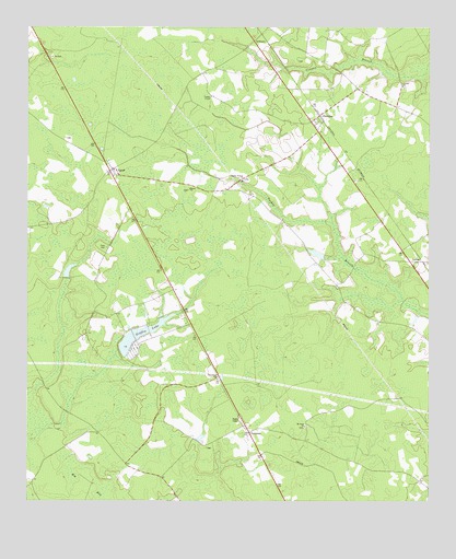
Egypt, GA USGS Topographic Map
Click on map above to begin viewing in our Map Viewer.

This topographic map contains these locations and features:
Feature Name Type Latitude Longitude GNIS ID View Map
Allison DamDamN32.3852°W81.4715°336266View Map
Allison LakeReservoirN32.3852°W81.4715°336267View Map
ArdmorePopulated PlaceN32.4952°W81.4287°331050View Map
Corinth ChurchChurchN32.4838°W81.3832°312987View Map
Effingham County Fire Rescue Station 10BuildingN32.4614°W81.4751°2735605View Map
Effingham County Fire Rescue Station 6BuildingN32.4522°W81.3918°2603602View Map
Effingham County Sheriff's Department Shawnee SubstationBuildingN32.4522°W81.3919°2734146View Map
EgyptPopulated PlaceN32.4618°W81.4740°355649View Map
Egypt ChurchChurchN32.4571°W81.4490°313873View Map
Elam CemeteryCemeteryN32.4418°W81.4754°313880View Map
Elam ChurchChurchN32.4627°W81.4732°350223View Map
Grafarwill Trust DamDamN32.4352°W81.4882°341100View Map
Grafarwill Trust PondReservoirN32.4356°W81.4874°341101View Map
Griffin LakeReservoirN32.4187°W81.4652°314911View Map
Griffin Lake DamDamN32.4199°W81.4621°337763View Map
Guyton Volunteer Fire Department Station 2BuildingN32.4270°W81.4634°2603616View Map
LorenzoPopulated PlaceN32.4377°W81.3768°332267View Map
Morgan PondReservoirN32.4403°W81.4101°341103View Map
Morgan Pond DamDamN32.4402°W81.4082°341102View Map
Mount Hope ChurchChurchN32.3944°W81.4132°318666View Map
Pine Grove School (historical)SchoolN32.3819°W81.4587°334653View Map
Rahn's GreenhousesBuildingN32.4756°W81.3936°2674797View Map
ShawneePopulated PlaceN32.4757°W81.4082°322811View Map
Shawnee DivisionCivilN32.4803°W81.4101°1936537View Map
Thomas ChapelChurchN32.4802°W81.4423°324078View Map
Turkey Branch ChurchChurchN32.4594°W81.4326°324367View Map
Turkey Creek Church (historical)ChurchN32.4646°W81.4348°334656View Map
TusculumPopulated PlaceN32.3930°W81.4307°326565View Map
Tusculum ChurchChurchN32.4069°W81.4407°324430View Map

Note: Coordinates in the location and feature list above are referenced to NAD83 datum.


Copyright (C) 2008-2025 Ryan Niemi / Sunset Dynamics ... All Rights Reserved