TopoQuest Logo
Do you find TopoQuest useful?
Help keep TopoQuest running and adding new maps/features by donating!
Bitcoin:  19c7KJd3qBynnjoSw5npx9KScwjBe4ifkT
Litecoin:  LXs6TkuXGGXo1vDsWCkWVdjQX94eUKd6ui
Home View Maps Find Maps Find Places Resources & Links


Hackleburg, Alabama Topographic Map

USGS Map Title: Hackleburg, AL
USGS Map MRC: 34087C7
DRG (GeoTIFF) Download: o34087c7.tif


Neighboring USGS Topographic Map Quads:


  Guinn Cross Roads, AL  
34087D8
 

  Isbell, AL  
34087D7
 

  Spruce Pine, AL  
34087D6
 

  Hodges, AL  
34087C8
 

  Hackleburg, AL  
34087C7
 

  Phil Campbell, AL  
34087C6
 

  Hamilton, AL  
34087B8
 

  Hamilton NE, AL  
34087B7
 

  Haleyville West, AL  
34087B6


Map MRC Location:

N35°
W88°
N35°
W87°
H8 H7 H6 H5 H4 H3 H2 H1
G8 G7 G6 G5 G4 G3 G2 G1
F8 F7 F6 F5 F4 F3 F2 F1
E8 E7 E6 E5 E4 E3 E2 E1
D8 D7 D6 D5 D4 D3 D2 D1
C8 C7 C6 C5 C4 C3 C2 C1
B8 B7 B6 B5 B4 B3 B2 B1
A8 A7 A6 A5 A4 A3 A2 A1
N34°
W88°
N34°
W87°

Hackleburg, AL USGS 1:24K Topographic Map Preview:
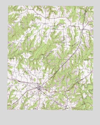
Hackleburg, AL USGS Topographic Map
Click on map above to begin viewing in our Map Viewer.

This topographic map contains these locations and features:
Feature Name Type Latitude Longitude GNIS ID View Map
Abison BranchStreamN34.3312°W87.8086°112895View Map
Adams CreekStreamN34.3140°W87.7931°112924View Map
Adams Memorial ChurchChurchN34.3318°W87.7950°112922View Map
Adams Poultry FarmLocaleN34.2686°W87.7514°2709206View Map
Antioch BranchStreamN34.2809°W87.7523°113103View Map
Antioch CemeteryCemeteryN34.2956°W87.7542°137922View Map
Antioch Missionary Baptist ChurchChurchN34.2957°W87.7536°113172View Map
Baggett BranchStreamN34.3054°W87.8153°113335View Map
Bailey BendBendN34.3109°W87.8398°113341View Map
Ball Park ChurchChurchN34.3557°W87.8578°136117View Map
Ballrock SchoolSchoolN34.3551°W87.8575°113431View Map
Bear Creek ChurchChurchN34.3326°W87.8548°113674View Map
Big BranchStreamN34.3051°W87.8584°114236View Map
Bluff CreekStreamN34.2990°W87.7828°114612View Map
Bluff Spring BranchStreamN34.3087°W87.8386°114620View Map
Brock CemeteryCemeteryN34.3523°W87.7978°114934View Map
Brodrick BranchStreamN34.3687°W87.7553°114938View Map
Brush CreekStreamN34.2779°W87.7700°115041View Map
Brush Creek BridgeBridgeN34.2570°W87.7636°115050View Map
Brush Creek HollowValleyN34.2526°W87.7642°115052View Map
Burfield BranchStreamN34.3098°W87.7695°115219View Map
Burnt House CemeteryCemeteryN34.2512°W87.8328°115268View Map
Cedar Tree CemeteryCemeteryN34.2776°W87.8242°137948View Map
Cleveland BranchStreamN34.3501°W87.8525°116253View Map
Cleveland CemeteryCemeteryN34.3495°W87.8381°116254View Map
Cochran Family CemeteryCemeteryN34.2681°W87.8503°137954View Map
Cold Spring BranchStreamN34.3098°W87.7709°116393View Map
Cook BranchStreamN34.3209°W87.8506°116526View Map
Cooper BranchStreamN34.2695°W87.7970°116570View Map
Cow BranchStreamN34.2965°W87.7920°116749View Map
Devil Den BranchStreamN34.3159°W87.8723°117245View Map
Dismal BranchStreamN34.2987°W87.8048°117299View Map
Dismals Wonder GardensParkN34.3257°W87.7820°136155View Map
DuketonPopulated PlaceN34.3651°W87.8323°156284View Map
East Prong Dismal BranchStreamN34.3234°W87.7814°117785View Map
Edgar BranchStreamN34.3351°W87.8092°117853View Map
Edgar CemeteryCemeteryN34.3509°W87.8111°117854View Map
Edgar ChapelChurchN34.3507°W87.8106°136161View Map
Evans BranchStreamN34.3032°W87.8053°118063View Map
Ezzell BranchStreamN34.3720°W87.8670°118098View Map
FairviewPopulated PlaceN34.2520°W87.7898°118129View Map
Fairview CemeteryCemeteryN34.2518°W87.7900°137963View Map
Fairview ChurchChurchN34.2515°W87.7900°137965View Map
First Baptist ChurchChurchN34.2757°W87.8261°137968View Map
First Methodist ChurchChurchN34.2773°W87.8236°137970View Map
Fortner CemeteryCemeteryN34.2995°W87.7692°118525View Map
Gourd Neck BranchStreamN34.3745°W87.7706°119190View Map
Gravel HillLocaleN34.3604°W87.8203°136176View Map
Gravel Hill ChurchChurchN34.3543°W87.8206°119266View Map
Gravel Hill ChurchChurchN34.3618°W87.8017°136177View Map
Gravel Hill SchoolSchoolN34.3607°W87.8203°119267View Map
Gravel Hill Volunteer Fire DepartmentBuildingN34.3603°W87.8114°2683153View Map
Grissom CemeteryCemeteryN34.3618°W87.8325°119429View Map
Gum Spring BranchStreamN34.3718°W87.7678°119484View Map
HackleburgPopulated PlaceN34.2773°W87.8286°119530View Map
Hackleburg Church of ChristChurchN34.2790°W87.8261°137986View Map
Hackleburg Church of God of ProphecyChurchN34.2820°W87.8314°137987View Map
Hackleburg DivisionCivilN34.2575°W87.8659°165881View Map
Hackleburg Fire DepartmentBuildingN34.2759°W87.8275°2682854View Map
Hackleburg Freewill Baptist ChurchChurchN34.2784°W87.8273°137988View Map
Hackleburg High SchoolSchoolN34.2815°W87.8306°137989View Map
Hackleburg Police DepartmentBuildingN34.2758°W87.8277°2751954View Map
Hackleburg Post OfficePost OfficeN34.2758°W87.8273°167821View Map
Hallman HollowValleyN34.3184°W87.7553°119587View Map
Hill Spring BranchStreamN34.2948°W87.7945°120110View Map
Holly HollowValleyN34.3132°W87.7598°120275View Map
Holly Springs School (historical)SchoolN34.3323°W87.7948°136187View Map
Howard BranchStreamN34.2895°W87.7711°120471View Map
Isom BranchStreamN34.3209°W87.7581°120719View Map
Ivy BranchStreamN34.3298°W87.7806°120730View Map
Jackson BranchStreamN34.3695°W87.7628°120757View Map
King BranchStreamN34.2695°W87.7970°121208View Map
Lauderdale BranchStreamN34.3209°W87.8461°121415View Map
Laurel BranchStreamN34.3154°W87.8228°121418View Map
Lawler CemeteryCemeteryN34.3704°W87.8392°121426View Map
Lawler Chapel ChurchChurchN34.3712°W87.8389°136195View Map
Liberty HillPopulated PlaceN34.3476°W87.7650°121568View Map
Liberty Hill CemeteryCemeteryN34.3440°W87.7670°136197View Map
Liberty Hill ChurchChurchN34.3432°W87.7670°136198View Map
Liberty Hill School (historical)SchoolN34.3462°W87.7667°136199View Map
Lindsey CemeteryCemeteryN34.3023°W87.8650°121664View Map
Lindsey CemeteryCemeteryN34.3293°W87.8667°121665View Map
Lower CemeteryCemeteryN34.2637°W87.8275°152166View Map
March BranchStreamN34.3176°W87.8570°122276View Map
McBrayer BranchStreamN34.3259°W87.7523°122448View Map
McCaig BranchStreamN34.3040°W87.7764°122454View Map
McDonald Spring BranchStreamN34.3190°W87.8650°122526View Map
McNair BranchStreamN34.2534°W87.7614°122592View Map
Middle ChurchChurchN34.2645°W87.8273°138011View Map
Military BridgeBridgeN34.3176°W87.8611°122728View Map
Miller CemeteryCemeteryN34.2859°W87.8634°122823View Map
Mitchell Spring BranchStreamN34.2512°W87.8195°122909View Map
Mixon Springs BranchStreamN34.2634°W87.8464°122914View Map
Moore BranchStreamN34.3026°W87.7803°122990View Map
New Prospect Baptist ChurchChurchN34.2773°W87.8739°153073View Map
New Prospect CemeteryCemeteryN34.2768°W87.8742°138032View Map
NixPopulated PlaceN34.3515°W87.7842°123950View Map
Nix BranchStreamN34.2962°W87.8039°123951View Map
Nix MillPopulated PlaceN34.3473°W87.8070°123953View Map
Nix Mill PondReservoirN34.3484°W87.8050°131998View Map
Nix Mill Pond DamDamN34.3484°W87.8050°131999View Map
Prices BridgeBridgeN34.3126°W87.8217°125272View Map
Purcell BranchStreamN34.2690°W87.7673°125366View Map
Rock Quarry BranchStreamN34.2840°W87.7745°125769View Map
Rocky BranchStreamN34.2634°W87.7642°125807View Map
Scharnagle BranchStreamN34.3737°W87.7706°112871View Map
Scott BranchStreamN34.3051°W87.8584°126474View Map
Shady Grove CemeteryCemeteryN34.3506°W87.7761°136271View Map
Shady Grove ChurchChurchN34.3509°W87.7770°126614View Map
Shingle Post Office (historical)Post OfficeN34.3651°W87.8323°166059View Map
Steele Mill BranchStreamN34.3690°W87.8123°127343View Map
Stone CemeteryCemeteryN34.3720°W87.8036°136290View Map
Strickland BranchStreamN34.3184°W87.8389°127464View Map
Sugar Hill School (historical)SchoolN34.3323°W87.8550°136291View Map
TessnerPopulated PlaceN34.2543°W87.7895°138074View Map
Town of HackleburgCivilN34.2693°W87.8303°2406635View Map
Wade CemeteryCemeteryN34.3706°W87.7931°136302View Map
Whitehead Spring BranchStreamN34.3126°W87.8200°128899View Map
Wildcat BranchStreamN34.3107°W87.8331°128963View Map

Note: Coordinates in the location and feature list above are referenced to NAD83 datum.


Copyright (C) 2008-2024 Ryan Niemi / Sunset Dynamics ... All Rights Reserved