TopoQuest Logo
Do you find TopoQuest useful?
Help keep TopoQuest running and adding new maps/features by donating!
Bitcoin:  19c7KJd3qBynnjoSw5npx9KScwjBe4ifkT
Litecoin:  LXs6TkuXGGXo1vDsWCkWVdjQX94eUKd6ui
Home View Maps Find Maps Find Places Resources & Links


Harmonsburg, Pennsylvania Topographic Map

USGS Map Title: Harmonsburg, PA
USGS Map MRC: 41080F3
DRG (GeoTIFF) Download: o41080f3.tif


Neighboring USGS Topographic Map Quads:


  Beaver Center, PA  
41080G4
 

  Conneautville, PA  
41080G3
 

  Edinboro South, PA  
41080G2
 

  Linesville, PA  
41080F4
 

  Harmonsburg, PA  
41080F3
 

  Meadville, PA  
41080F2
 

  Hartstown, PA  
41080E4
 

  Conneaut Lake, PA  
41080E3
 

  Geneva, PA  
41080E2


Map MRC Location:

N42°
W81°
N42°
W80°
H8 H7 H6 H5 H4 H3 H2 H1
G8 G7 G6 G5 G4 G3 G2 G1
F8 F7 F6 F5 F4 F3 F2 F1
E8 E7 E6 E5 E4 E3 E2 E1
D8 D7 D6 D5 D4 D3 D2 D1
C8 C7 C6 C5 C4 C3 C2 C1
B8 B7 B6 B5 B4 B3 B2 B1
A8 A7 A6 A5 A4 A3 A2 A1
N41°
W81°
N41°
W80°

Harmonsburg, PA USGS 1:24K Topographic Map Preview:
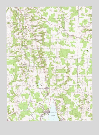
Harmonsburg, PA USGS Topographic Map
Click on map above to begin viewing in our Map Viewer.

This topographic map contains these locations and features:
Feature Name Type Latitude Longitude GNIS ID View Map
Beech SchoolSchoolN41.7262°W80.2926°1205430View Map
Big Road SchoolSchoolN41.7042°W80.3306°1205425View Map
Breckenridge CemeteryCemeteryN41.6498°W80.2611°1170186View Map
Breckenridge School (historical)SchoolN41.6481°W80.2606°1205419View Map
Carr SchoolSchoolN41.7451°W80.3287°1205433View Map
Center School (historical)SchoolN41.7251°W80.3290°1205429View Map
Chestnut CornersLocaleN41.6851°W80.3509°1171701View Map
Clearwater LakeLakeN41.6657°W80.3270°1171981View Map
Conneaut Lake ParkPopulated PlaceN41.6356°W80.3148°1172340View Map
Conneaut Lake Park Volunteer Fire Department 5BuildingN41.6293°W80.3265°2645328View Map
Conneaut Lakeshore Census Designated PlaceCensusN41.6272°W80.3102°2389354View Map
Cooper School (historical)SchoolN41.7445°W80.2823°1205432View Map
DicksonburgPopulated PlaceN41.7053°W80.3520°1173257View Map
Dicksonburg CemeteryCemeteryN41.7075°W80.3496°1173258View Map
Fish CornersLocaleN41.7303°W80.3692°1174802View Map
Fish CreekStreamN41.7306°W80.3559°1174803View Map
Gehrton School (historical)SchoolN41.6467°W80.3606°1205418View Map
HarmonsburgPopulated PlaceN41.6609°W80.3178°1176540View Map
Harmonsburg Census Designated PlaceCensusN41.6655°W80.3142°2389901View Map
Harmonsburg Post OfficePost OfficeN41.6617°W80.3174°2772735View Map
Harmonsburg StationLocaleN41.6642°W80.3431°1205421View Map
Inlet RunStreamN41.6384°W80.3112°1177816View Map
Inlet School (historical)SchoolN41.7142°W80.3006°1205428View Map
Iron Wood Golf CourseLocaleN41.6373°W80.2976°1206757View Map
Jolly CemeteryCemeteryN41.6856°W80.3512°1178139View Map
Lefevre SchoolSchoolN41.7101°W80.2542°1205426View Map
McDowell CemeteryCemeteryN41.7196°W80.3478°1180697View Map
Meadville JunctionPopulated PlaceN41.6389°W80.3451°1204144View Map
NorrisvillePopulated PlaceN41.7159°W80.2701°1182509View Map
Park Golf CourseLocaleN41.6453°W80.3178°1206560View Map
Pine RunStreamN41.6623°W80.3017°1183885View Map
Putnam SchoolSchoolN41.6539°W80.2848°1205420View Map
Rockwall SchoolSchoolN41.6792°W80.2706°1205422View Map
ShermansvillePopulated PlaceN41.6259°W80.3740°1193345View Map
Smith SchoolSchoolN41.6839°W80.3042°1205423View Map
Stanford School (historical)SchoolN41.7276°W80.2664°1205431View Map
Summit Township Volunteer Fire Department 20BuildingN41.6611°W80.3163°2645490View Map
Townline School (historical)SchoolN41.7042°W80.2709°1205427View Map
Township of SummerhillCivilN41.7242°W80.3299°1216319View Map
Township of SummitCivilN41.6647°W80.3318°1216320View Map
Watson RunPopulated PlaceN41.6556°W80.2645°1204908View Map
Whiting CornersLocaleN41.6939°W80.2701°1205424View Map

Note: Coordinates in the location and feature list above are referenced to NAD83 datum.


Copyright (C) 2008-2024 Ryan Niemi / Sunset Dynamics ... All Rights Reserved