TopoQuest Logo
Do you find TopoQuest useful?
Help keep TopoQuest running and adding new maps/features by donating!
Bitcoin:  19c7KJd3qBynnjoSw5npx9KScwjBe4ifkT
Litecoin:  LXs6TkuXGGXo1vDsWCkWVdjQX94eUKd6ui
Home View Maps Find Maps Find Places Resources & Links


Harrison Valley, Pennsylvania Topographic Map

USGS Map Title: Harrison Valley, PA
USGS Map MRC: 41077H6
DRG (GeoTIFF) Download: o41077h6.tif


Neighboring USGS Topographic Map Quads:


  Whitesville, NY  
42077A7
 

  Rexville, NY  
42077A6
 

  Troupsburg, NY  
42077A5
 

  Ulysses, PA  
41077H7
 

  Harrison Valley, PA  
41077H6
 

  Potter Brook, PA  
41077H5
 

  Brookland, PA  
41077G7
 

  West Pike, PA  
41077G6
 

  Sabinsville, PA  
41077G5


Map MRC Location:

N42°
W78°
N42°
W77°
H8 H7 H6 H5 H4 H3 H2 H1
G8 G7 G6 G5 G4 G3 G2 G1
F8 F7 F6 F5 F4 F3 F2 F1
E8 E7 E6 E5 E4 E3 E2 E1
D8 D7 D6 D5 D4 D3 D2 D1
C8 C7 C6 C5 C4 C3 C2 C1
B8 B7 B6 B5 B4 B3 B2 B1
A8 A7 A6 A5 A4 A3 A2 A1
N41°
W78°
N41°
W77°

Harrison Valley, PA USGS 1:24K Topographic Map Preview:
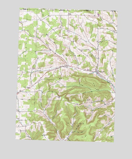
Harrison Valley, PA USGS Topographic Map
Click on map above to begin viewing in our Map Viewer.

This topographic map contains these locations and features:
Feature Name Type Latitude Longitude GNIS ID View Map
Bailey HillSummitN41.8798°W77.7142°1168577View Map
Big LevelSummitN41.8806°W77.6608°1169531View Map
Big WidgerValleyN41.8844°W77.6737°1169606View Map
Button HollowValleyN41.8981°W77.6285°1170821View Map
Button HollowValleyN41.9291°W77.6701°1170822View Map
Dennis HillSummitN41.9340°W77.6961°1173156View Map
Dodge HollowValleyN41.9224°W77.6269°1173334View Map
Dry HollowValleyN41.9246°W77.6500°1173517View Map
Fay HollowValleyN41.8831°W77.6785°1174646View Map
HarrisonPopulated PlaceN41.9162°W77.7047°1198005View Map
Harrison Township Volunteer Fire Company Station 20BuildingN41.9409°W77.6471°2644933View Map
Harrison ValleyPopulated PlaceN41.9420°W77.6494°1176589View Map
Kibbe Field (historical)AirportN41.9784°W77.7097°1194317View Map
Little WidgerValleyN41.8843°W77.6734°1179713View Map
Marsh CreekStreamN41.9456°W77.6844°1180443View Map
MillsPopulated PlaceN41.9462°W77.6864°1181279View Map
Mills Post OfficePost OfficeN41.9465°W77.6843°2773209View Map
Moore HollowValleyN41.9161°W77.6254°1181506View Map
North Branch Cowanesque RiverStreamN41.9412°W77.6492°1182534View Map
North Fork DamDamN41.9967°W77.6547°1195880View Map
North Fork ReservoirReservoirN41.9967°W77.6547°1195881View Map
Northern Potter SchoolSchoolN41.9245°W77.7342°1182672View Map
Northern Tier Childrens HomeBuildingN41.9431°W77.6608°1182673View Map
Susquehannock State ForestAreaN41.8859°W77.7039°1198004View Map
Swartz HollowValleyN41.8946°W77.7050°1189144View Map
Township of HarrisonCivilN41.9561°W77.6681°1216973View Map
White KnollSummitN41.9165°W77.6972°1191286View Map
Whites CornersLocaleN41.9945°W77.6858°1191334View Map

Note: Coordinates in the location and feature list above are referenced to NAD83 datum.


Copyright (C) 2008-2025 Ryan Niemi / Sunset Dynamics ... All Rights Reserved