TopoQuest Logo
Do you find TopoQuest useful?
Help keep TopoQuest running and adding new maps/features by donating!
Bitcoin:  19c7KJd3qBynnjoSw5npx9KScwjBe4ifkT
Litecoin:  LXs6TkuXGGXo1vDsWCkWVdjQX94eUKd6ui
Home View Maps Find Maps Find Places Resources & Links


Ulysses, Pennsylvania Topographic Map

USGS Map Title: Ulysses, PA
USGS Map MRC: 41077H7
DRG (GeoTIFF) Download: o41077h7.tif


Neighboring USGS Topographic Map Quads:


  Wellsville South, NY  
42077A8
 

  Whitesville, NY  
42077A7
 

  Rexville, NY  
42077A6
 

  Ellisburg, PA  
41077H8
 

  Ulysses, PA  
41077H7
 

  Harrison Valley, PA  
41077H6
 

  Sweden Valley, PA  
41077G8
 

  Brookland, PA  
41077G7
 

  West Pike, PA  
41077G6


Map MRC Location:

N42°
W78°
N42°
W77°
H8 H7 H6 H5 H4 H3 H2 H1
G8 G7 G6 G5 G4 G3 G2 G1
F8 F7 F6 F5 F4 F3 F2 F1
E8 E7 E6 E5 E4 E3 E2 E1
D8 D7 D6 D5 D4 D3 D2 D1
C8 C7 C6 C5 C4 C3 C2 C1
B8 B7 B6 B5 B4 B3 B2 B1
A8 A7 A6 A5 A4 A3 A2 A1
N41°
W78°
N41°
W77°

Ulysses, PA USGS 1:24K Topographic Map Preview:
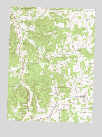
Ulysses, PA USGS Topographic Map
Click on map above to begin viewing in our Map Viewer.

This topographic map contains these locations and features:
Feature Name Type Latitude Longitude GNIS ID View Map
Ainsworth BrookStreamN41.9956°W77.8172°942214View Map
Bingham CenterPopulated PlaceN41.9540°W77.7764°1203096View Map
Bingham Station (historical)LocaleN41.9403°W77.7503°1197635View Map
Borough of UlyssesCivilN41.9030°W77.7548°1215542View Map
Cotton BrookStreamN41.9745°W77.8517°1172489View Map
Cryder CreekStreamN41.9981°W77.8697°947882View Map
GeneseePopulated PlaceN41.9892°W77.8658°1192508View Map
Genesee Post OfficePost OfficeN41.9901°W77.8690°2773146View Map
Genesee Township Volunteer Fire DepartmentBuildingN41.9941°W77.8717°2645487View Map
HarmontownPopulated PlaceN41.9220°W77.8542°1203752View Map
HickoxPopulated PlaceN41.9762°W77.8561°1203797View Map
Jackson SchoolSchoolN41.9242°W77.7680°1197634View Map
Kibboville CornersLocaleN41.8881°W77.7978°1178442View Map
Ludington RunStreamN41.9390°W77.8122°1198159View Map
Middle Branch Genesee RiverStreamN41.9753°W77.8569°1181008View Map
Mundy BrookStreamN41.9834°W77.8614°1182090View Map
Musto HollowValleyN41.9366°W77.8023°1182121View Map
NewfieldPopulated PlaceN41.8801°W77.8139°1204283View Map
Newfield SchoolSchoolN41.8920°W77.8061°1197633View Map
North BinghamPopulated PlaceN41.9873°W77.7617°1182520View Map
North Bingham CemeteryCemeteryN41.9974°W77.7630°1182521View Map
Pusher SidingLocaleN41.9048°W77.8019°1184505View Map
Shanty HollowValleyN41.9513°W77.8236°1187365View Map
Township of BinghamCivilN41.9557°W77.7866°1216969View Map
Tri -Town Fire CompanyBuildingN41.9037°W77.7719°2645293View Map
Turner CreekStreamN41.9459°W77.8172°1189958View Map
UlyssesPopulated PlaceN41.9040°W77.7619°1190075View Map
Ulysses Post OfficePost OfficeN41.9047°W77.7618°2773009View Map
Ulysses Post Office (historical)Post OfficeN41.9040°W77.7619°1214153View Map
United States SchoolSchoolN41.9962°W77.8172°1197632View Map
West BinghamPopulated PlaceN41.9445°W77.8164°1204925View Map
West Branch Genesee RiverStreamN41.9920°W77.8694°1190907View Map
Wolf HollowValleyN41.9569°W77.8299°1191661View Map

Note: Coordinates in the location and feature list above are referenced to NAD83 datum.


Copyright (C) 2008-2024 Ryan Niemi / Sunset Dynamics ... All Rights Reserved