TopoQuest Logo
Do you find TopoQuest useful?
Help keep TopoQuest running and adding new maps/features by donating!
Bitcoin:  19c7KJd3qBynnjoSw5npx9KScwjBe4ifkT
Litecoin:  LXs6TkuXGGXo1vDsWCkWVdjQX94eUKd6ui
Home View Maps Find Maps Find Places Resources & Links


Hebo, Oregon Topographic Map

USGS Map Title: Hebo, OR
USGS Map MRC: 45123B7
DRG (GeoTIFF) Download: o45123b7.tif


Neighboring USGS Topographic Map Quads:


  Sand Lake, OR  
45123C8
 

  Beaver, OR  
45123C7
 

  Blaine, OR  
45123C6
 

  Nestucca Bay, OR  
45123B8
 

  Hebo, OR  
45123B7
 

  Niagara Creek, OR  
45123B6
 

  Neskowin, OR  
45123A8
 

  Dolph, OR  
45123A7
 

  Midway, OR  
45123A6


Map MRC Location:

N46°
W124°
N46°
W123°
H8 H7 H6 H5 H4 H3 H2 H1
G8 G7 G6 G5 G4 G3 G2 G1
F8 F7 F6 F5 F4 F3 F2 F1
E8 E7 E6 E5 E4 E3 E2 E1
D8 D7 D6 D5 D4 D3 D2 D1
C8 C7 C6 C5 C4 C3 C2 C1
B8 B7 B6 B5 B4 B3 B2 B1
A8 A7 A6 A5 A4 A3 A2 A1
N45°
W124°
N45°
W123°

Hebo, OR USGS 1:24K Topographic Map Preview:
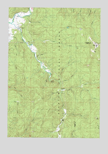
Hebo, OR USGS Topographic Map
Click on map above to begin viewing in our Map Viewer.

This topographic map contains these locations and features:
Feature Name Type Latitude Longitude GNIS ID View Map
Alder CreekStreamN45.1709°W123.8046°1137073View Map
Buck CreekStreamN45.1487°W123.7990°1138766View Map
Castle RockLocaleN45.1798°W123.8207°1153491View Map
Castle Rock Recreation SiteLocaleN45.1790°W123.8193°1153490View Map
Castlerock LodgeLocaleN45.1798°W123.8207°1139450View Map
Cedar CreekStreamN45.2128°W123.8486°1139508View Map
Cedar Creek Administration Site Fish HatcheryLocaleN45.2143°W123.8462°1162582View Map
Cedar Creek HatcheryLocaleN45.2143°W123.8471°1167197View Map
Cedar LakeLakeN45.2113°W123.7838°1139523View Map
Condor BridgeBridgeN45.2437°W123.8623°1162242View Map
Crazy CreekStreamN45.1737°W123.7787°1140421View Map
Dorothy CreekStreamN45.2009°W123.8387°1154294View Map
Gauldy RidgeRidgeN45.1618°W123.8318°1142592View Map
George CreekStreamN45.2407°W123.8579°1142614View Map
Gist CemeteryCemeteryN45.2037°W123.8386°1163581View Map
Happy HollowPopulated PlaceN45.1423°W123.8037°1143281View Map
HeboPopulated PlaceN45.2304°W123.8634°1143441View Map
Hebo Census Designated PlaceCensusN45.2260°W123.8586°2408369View Map
Hebo Joint Water and Sanitary AuthorityLocaleN45.2309°W123.8631°2660698View Map
Hebo LakeReservoirN45.2310°W123.7959°1143442View Map
Hebo Lake Recreation SiteLocaleN45.2304°W123.7984°1153489View Map
Hebo Post OfficePost OfficeN45.2293°W123.8623°1165381View Map
Hebo Work CampLocaleN45.2171°W123.8473°1143443View Map
Herbst PlaceLocaleN45.1907°W123.8496°1143506View Map
KTIL-FMTowerN45.2234°W123.7676°1158727View Map
Lawrence CreekStreamN45.1771°W123.8059°1144889View Map
Little HeboSummitN45.1451°W123.7521°1145179View Map
Mount GauldySummitN45.1615°W123.8318°1142593View Map
Mount HeboSummitN45.2148°W123.7565°1143444View Map
Mount Hebo Air Force Station (historical)MilitaryN45.2147°W123.7564°2089731View Map
Nestucca Rural Fire Protection District Station 81 HeadquartersBuildingN45.2320°W123.8631°2576513View Map
Nestucca Valley Community CemeteryCemeteryN45.2274°W123.8714°1130669View Map
Pollard CreekStreamN45.1790°W123.8071°1147863View Map
Rhodes Rearing PondReservoirN45.1709°W123.8018°1134486View Map
Rock CreekStreamN45.1543°W123.8018°1153488View Map
Siuslaw National Forest Hebo Ranger DistrictBuildingN45.2269°W123.8585°1159341View Map
South PointSummitN45.2082°W123.7598°1150067View Map
Spring CreekStreamN45.2215°W123.8582°1153492View Map
Three Rivers County Drift Boat LaunchLocaleN45.2347°W123.8743°2668609View Map
Tucker SpringSpringN45.2165°W123.8734°1153456View Map
United States Forest Service Hebo Ranger DistrictBuildingN45.2269°W123.8585°2576672View Map
Woods CreekStreamN45.1676°W123.8054°1152641View Map

Note: Coordinates in the location and feature list above are referenced to NAD83 datum.


Copyright (C) 2008-2025 Ryan Niemi / Sunset Dynamics ... All Rights Reserved