TopoQuest Logo
Do you find TopoQuest useful?
Help keep TopoQuest running and adding new maps/features by donating!
Bitcoin:  19c7KJd3qBynnjoSw5npx9KScwjBe4ifkT
Litecoin:  LXs6TkuXGGXo1vDsWCkWVdjQX94eUKd6ui
Home View Maps Find Maps Find Places Resources & Links


Howell, Mississippi Topographic Map

USGS Map Title: Howell, MS
USGS Map MRC: 30088G4
DRG (GeoTIFF) Download: o30088g4.tif


Neighboring USGS Topographic Map Quads:


  Lucedale, MS  
30088H5
 

  Earlville, AL  
30088H4
 

  Georgetown, AL  
30088H3
 

  Agricola, MS  
30088G5
 

  Howell, MS  
30088G4
 

  Semmes, AL  
30088G3
 

  Harleston, MS  
30088F5
 

  Hurley, MS  
30088F4
 

  Tanner Williams, AL  
30088F3


Map MRC Location:

N31°
W89°
N31°
W88°
H8 H7 H6 H5 H4 H3 H2 H1
G8 G7 G6 G5 G4 G3 G2 G1
F8 F7 F6 F5 F4 F3 F2 F1
E8 E7 E6 E5 E4 E3 E2 E1
D8 D7 D6 D5 D4 D3 D2 D1
C8 C7 C6 C5 C4 C3 C2 C1
B8 B7 B6 B5 B4 B3 B2 B1
A8 A7 A6 A5 A4 A3 A2 A1
N30°
W89°
N30°
W88°

Howell, MS USGS 1:24K Topographic Map Preview:
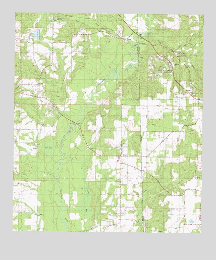
Howell, MS USGS Topographic Map
Click on map above to begin viewing in our Map Viewer.

This topographic map contains these locations and features:
Feature Name Type Latitude Longitude GNIS ID View Map
A D Hall Lake DamDamN30.8602°W88.4834°680522View Map
Dean BaySwampN30.7979°W88.4771°669173View Map
Dean LandingPopulated PlaceN30.7813°W88.4725°691804View Map
Evangel Temple Christian AcademySchoolN30.7563°W88.4326°2132760View Map
Evans FieldAirportN30.8111°W88.3776°2676349View Map
Finch CemeteryCemeteryN30.8099°W88.4808°669961View Map
Gulf Coast Bible CampLocaleN30.8710°W88.4745°690727View Map
HowellPopulated PlaceN30.7938°W88.4289°690730View Map
Howell BridgeBridgeN30.8088°W88.4617°671535View Map
Howell CemeteryCemeteryN30.7935°W88.4314°709188View Map
Howell Missionary Baptist ChurchChurchN30.7935°W88.4308°709189View Map
Howell SchoolSchoolN30.7932°W88.4295°671538View Map
Howell Volunteer Fire DepartmentBuildingN30.7935°W88.4299°2667803View Map
Howells Ferry (historical)CrossingN30.8127°W88.4581°687104View Map
Juniper BaySwampN30.7709°W88.4521°672058View Map
LatoniaPopulated PlaceN30.8610°W88.4278°690731View Map
Midway Baptist ChurchChurchN30.7610°W88.4286°690737View Map
Midway CemeteryCemeteryN30.7605°W88.4286°709194View Map
MoffetPopulated PlaceN30.8544°W88.3975°156725View Map
Moffet CemeteryCemeteryN30.8505°W88.4164°122930View Map
Moffet SchoolSchoolN30.8527°W88.3892°122931View Map
Moffetville CemeteryCemeteryN30.8463°W88.3945°143558View Map
Moffetville ChurchChurchN30.8530°W88.3897°143559View Map
Palestine ChurchChurchN30.7821°W88.3778°124383View Map
Red CreekStreamN30.8144°W88.4564°676523View Map
Red Creek ChurchChurchN30.8335°W88.4842°676525View Map
Rocky CreekStreamN30.8557°W88.4217°676785View Map
Scarbo CreekStreamN30.8652°W88.4117°126457View Map
Supervisor District 2CivilN30.8056°W88.4988°711854View Map
Tanner Williams Volunteer Fire DepartmentBuildingN30.7791°W88.3783°2691176View Map
Ward CemeteryCemeteryN30.8277°W88.4111°128572View Map
Waters LandingPopulated PlaceN30.7907°W88.4647°692309View Map
West Wilmer ChurchChurchN30.8507°W88.4008°1730045View Map
West Wilmer ChurchChurchN30.8413°W88.4050°1730046View Map
Wilmer ChurchChurchN30.8416°W88.4000°143938View Map

Note: Coordinates in the location and feature list above are referenced to NAD83 datum.


Copyright (C) 2008-2025 Ryan Niemi / Sunset Dynamics ... All Rights Reserved