TopoQuest Logo
Do you find TopoQuest useful?
Help keep TopoQuest running and adding new maps/features by donating!
Bitcoin:  19c7KJd3qBynnjoSw5npx9KScwjBe4ifkT
Litecoin:  LXs6TkuXGGXo1vDsWCkWVdjQX94eUKd6ui
Home View Maps Find Maps Find Places Resources & Links


Hoyt, Montana Topographic Map

USGS Map Title: Hoyt, MT
USGS Map MRC: 46104H7
DRG (GeoTIFF) Download: o46104h7.tif


Neighboring USGS Topographic Map Quads:


  Pleasant View, MT  
47104A8
 

  Forest Park, MT  
47104A7
 

  Glendive, MT  
47104A6
 

  Marsh, MT  
46104H8
 

  Hoyt, MT  
46104H7
 

  Upper Magpie Reservoir, MT  
46104H6
 

  Marsh SW, MT  
46104G8
 

  Simons Butte, MT  
46104G7
 

  Graveyard Hill SW, MT  
46104G6


Map MRC Location:

N47°
W105°
N47°
W104°
H8 H7 H6 H5 H4 H3 H2 H1
G8 G7 G6 G5 G4 G3 G2 G1
F8 F7 F6 F5 F4 F3 F2 F1
E8 E7 E6 E5 E4 E3 E2 E1
D8 D7 D6 D5 D4 D3 D2 D1
C8 C7 C6 C5 C4 C3 C2 C1
B8 B7 B6 B5 B4 B3 B2 B1
A8 A7 A6 A5 A4 A3 A2 A1
N46°
W105°
N46°
W104°

Hoyt, MT USGS 1:24K Topographic Map Preview:
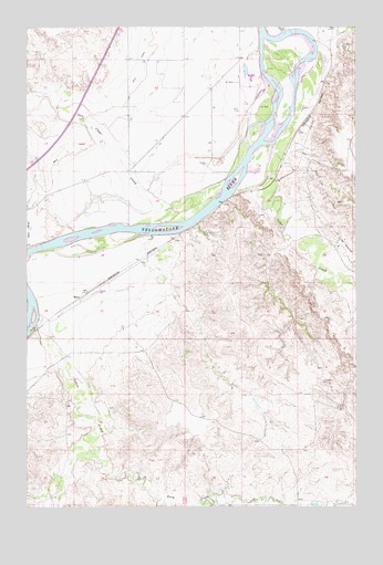
Hoyt, MT USGS Topographic Map
Click on map above to begin viewing in our Map Viewer.

This topographic map contains these locations and features:
Feature Name Type Latitude Longitude GNIS ID View Map
10N55E07CBBB01 WellWellN46.8839°W104.8583°819085View Map
13N53E10CAAA01 WellWellN46.9761°W104.8327°819867View Map
13N54E06CBD_01 WellWellN46.9689°W104.8511°819824View Map
13N55E07DD__01 WellWellN46.8925°W104.7964°819188View Map
13N55E18DC__01 WellWellN46.8781°W104.8016°819020View Map
14N53E15CDBD01 WellWellN46.9761°W104.8169°819865View Map
14N54E01CCC_01 WellWellN46.9978°W104.8169°820035View Map
14N54E01DAA_01 WellWellN46.9978°W104.8247°820036View Map
14N54E01DBB_01 WellWellN46.9853°W104.8247°819942View Map
14N54E12AB__01 WellWellN46.9897°W104.8236°819973View Map
14N54E12ACC_01 WellWellN46.9797°W104.8327°819902View Map
14N54E12CCA_01 WellWellN46.9833°W104.8169°819929View Map
14N54E12DAA_01 WellWellN46.9797°W104.8247°819901View Map
14N54E12DCB_01 WellWellN46.9778°W104.8247°819886View Map
14N54E13AAA_01 WellWellN46.9761°W104.8247°819866View Map
14N54E13AC__01 WellWellN46.9717°W104.8236°819844View Map
14N54E13BBA_01 WellWellN46.9706°W104.8275°819841View Map
14N54E13BBAB01 WellWellN46.9653°W104.8327°819782View Map
14N54E13CCA_01 WellWellN46.9633°W104.8275°819752View Map
14N54E13CDD_01 WellWellN46.9689°W104.8247°819822View Map
14N54E13DB__01 WellWellN46.9692°W104.8252°819828View Map
14N54E13DBBA01 WellWellN46.9697°W104.8250°819829View Map
14N54E13DBBB01 WellWellN46.9670°W104.8222°819811View Map
14N54E13DBD_01 WellWellN46.9633°W104.8222°819751View Map
14N54E13DCD_01 WellWellN46.9761°W104.8380°819868View Map
14N54E14AAA_01 WellWellN46.9689°W104.8380°819823View Map
14N54E14AD__01 WellWellN46.9717°W104.8394°819845View Map
14N54E14CAB_01 WellWellN46.9617°W104.8669°819730View Map
14N54E14DAA_01 WellWellN46.9617°W104.8194°819727View Map
14N54E22ABB_01 WellWellN46.9617°W104.8433°819729View Map
14N54E22BDDD01 WellWellN46.9561°W104.8689°819675View Map
14N54E23ABA_01 WellWellN46.9597°W104.8539°819708View Map
14N54E23BBD_01 WellWellN46.9561°W104.8511°819674View Map
14N54E23BC__01 WellWellN46.9570°W104.8552°819681View Map
14N54E23BDC_01 WellWellN46.9572°W104.8511°819684View Map
14N54E23CAB_01 WellWellN46.9525°W104.8486°819620View Map
14N54E23CAD_01 WellWellN46.9525°W104.8380°819619View Map
14N54E23DAD_01 WellWellN46.9545°W104.8433°819652View Map
14N54E23DBA_01 WellWellN46.9925°W104.8352°819994View Map
14N54E24AAB_01 WellWellN46.9597°W104.8194°819706View Map
14N54E24AAC_01 WellWellN46.9617°W104.8247°819728View Map
14N54E24ABB_01 WellWellN46.9597°W104.8247°819707View Map
14N54E24ABC_01 WellWellN46.9581°W104.8169°819694View Map
14N54E25BB__01 WellWellN46.9461°W104.8341°819558View Map
14N54E26CA__01 WellWellN46.9389°W104.8500°819509View Map
14N54E34CAAC01 WellWellN46.9253°W104.8705°819423View Map
14N55E04DCBD01 WellWellN46.9939°W104.7608°820002View Map
14N55E06ABC_01 WellWellN46.9992°W104.8008°820041View Map
14N55E06ACD_01 WellWellN46.9992°W104.7955°820040View Map
14N55E06BAA_01 WellWellN46.9992°W104.8089°820043View Map
14N55E06BDD_01 WellWellN46.9992°W104.8061°820042View Map
14N55E06BDD_02 WellWellN46.9956°W104.8089°820020View Map
14N55E06CAC_01 WellWellN46.9920°W104.8141°819988View Map
14N55E06CCC_01 WellWellN46.9956°W104.7955°820018View Map
14N55E06DAD_01 WellWellN46.9956°W104.8036°820019View Map
14N55E06DBC_01 WellWellN46.9920°W104.7983°819987View Map
14N55E06DDC_01 WellWellN46.9864°W104.8008°819954View Map
14N55E07ACA_01 WellWellN46.9847°W104.7955°819937View Map
14N55E07ADD_01 WellWellN46.9883°W104.8061°819971View Map
14N55E07BDA_01 WellWellN46.9864°W104.8061°819955View Map
14N55E07BDA_02 WellWellN46.9864°W104.8061°819956View Map
14N55E07BDA_03 WellWellN46.9864°W104.8061°819957View Map
14N55E07BDA_04 WellWellN46.9864°W104.8061°819958View Map
14N55E07BDA_05 WellWellN46.9808°W104.8089°819909View Map
14N55E07CAC_01 WellWellN46.9772°W104.8061°819879View Map
14N55E07CDD_01 WellWellN46.9792°W104.8036°819897View Map
14N55E07DC__01 WellWellN46.9783°W104.8022°819892View Map
14N55E07DCB_01 WellWellN46.9792°W104.7955°819896View Map
14N55E07DDA_01 WellWellN46.9736°W104.8061°819853View Map
14N55E18BAD_01 WellWellN46.9683°W104.8061°819815View Map
14N55E18CAA_01 WellWellN46.9647°W104.8141°819778View Map
14N55E18CCC_01 WellWellN46.9628°W104.8141°819743View Map
14N55E18CCC_02 WellWellN46.9628°W104.8141°819744View Map
14N55E18CCC_03 WellWellN46.9628°W104.8141°819745View Map
14N55E18CCC_04 WellWellN46.9628°W104.8114°819742View Map
14N55E18CCD_01 WellWellN46.9647°W104.8061°819777View Map
14N55E18CDA_01 WellWellN46.9628°W104.8061°819741View Map
14N55E18CDD_01 WellWellN46.9628°W104.7983°819740View Map
14N55E18DDC_01 WellWellN46.9611°W104.8061°819722View Map
14N55E19BAA_01 WellWellN46.9592°W104.8114°819696View Map
14N55E19BBD_01 WellWellN46.9575°W104.8061°819688View Map
14N55E29ACCD01 WellWellN46.9411°W104.7814°819526View Map
14N55E31CBBB01 WellWellN46.9258°W104.8152°819426View Map
15N55E30CDB_01 WellWellN46.9356°W104.8089°819485View Map
Cabin CreekStreamN46.9228°W104.8714°769484View Map
Cedar CreekStreamN46.9625°W104.7839°769711View Map
Clear CreekStreamN46.9603°W104.7997°769920View Map
Glueckstal CemeteryCemeteryN46.8767°W104.8058°1955146View Map
HoytLocaleN46.9306°W104.8527°1715370View Map
HoytPopulated PlaceN46.9297°W104.8547°772594View Map
Hoyt Post Office (historical)Post OfficeN46.9306°W104.8527°1715369View Map
Hoyt School (historical)SchoolN46.8903°W104.7733°1715536View Map
Huey CreekStreamN46.8872°W104.8497°799170View Map
Main CanalCanalN46.9895°W104.8314°773836View Map
Monroe CreekStreamN46.9467°W104.8577°1715340View Map
Monroe IslandIslandN46.9722°W104.7894°1715606View Map
Sand CreekStreamN46.9458°W104.8283°1715473View Map
Smokey CouleeValleyN46.9450°W104.7750°1715472View Map
South Fork Huey CreekStreamN46.8753°W104.8127°799194View Map
Stanleys Stockade (historical)MilitaryN46.9267°W104.8694°1716269View Map
Townhouse DamDamN46.9900°W104.7922°798178View Map
Western Gravel SpurLocaleN46.9958°W104.7597°1715343View Map

Note: Coordinates in the location and feature list above are referenced to NAD83 datum.


Copyright (C) 2008-2025 Ryan Niemi / Sunset Dynamics ... All Rights Reserved