TopoQuest Logo
Do you find TopoQuest useful?
Help keep TopoQuest running and adding new maps/features by donating!
Bitcoin:  19c7KJd3qBynnjoSw5npx9KScwjBe4ifkT
Litecoin:  LXs6TkuXGGXo1vDsWCkWVdjQX94eUKd6ui
Home View Maps Find Maps Find Places Resources & Links


Mount Judea, Arkansas Topographic Map

USGS Map Title: Mount Judea, AR
USGS Map MRC: 35093H1
DRG (GeoTIFF) Download: o35093h1.tif


Neighboring USGS Topographic Map Quads:


  Jasper, AR  
36093A2
 

  Hasty, AR  
36093A1
 

  Western Grove, AR  
36092A8
 

  Parthenon, AR  
35093H2
 

  Mount Judea, AR  
35093H1
 

  Eula, AR  
35092H8
 

  Deer, AR  
35093G2
 

  Lurton, AR  
35093G1
 

  Moore, AR  
35092G8


Map MRC Location:

N36°
W94°
N36°
W93°
H8 H7 H6 H5 H4 H3 H2 H1
G8 G7 G6 G5 G4 G3 G2 G1
F8 F7 F6 F5 F4 F3 F2 F1
E8 E7 E6 E5 E4 E3 E2 E1
D8 D7 D6 D5 D4 D3 D2 D1
C8 C7 C6 C5 C4 C3 C2 C1
B8 B7 B6 B5 B4 B3 B2 B1
A8 A7 A6 A5 A4 A3 A2 A1
N35°
W94°
N35°
W93°

Mount Judea, AR USGS 1:24K Topographic Map Preview:
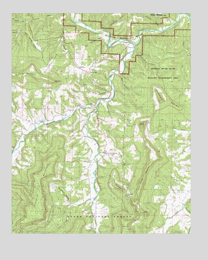
Mount Judea, AR USGS Topographic Map
Click on map above to begin viewing in our Map Viewer.

This topographic map contains these locations and features:
Feature Name Type Latitude Longitude GNIS ID View Map
Atkinson SchoolSchoolN35.9715°W93.0971°70477View Map
Bethlehem ChurchChurchN35.9362°W93.0452°59344View Map
Big CreekStreamN35.9826°W93.0405°70665View Map
Big Creek ChurchChurchN35.9454°W93.0849°59342View Map
Buffalo River State Wildlife Management AreaParkN35.9801°W93.0180°74412View Map
Campbell GapGapN35.8965°W93.0446°59349View Map
CarverPopulated PlaceN35.9862°W93.0418°71025View Map
Carver CemeteryCemeteryN35.9804°W93.0443°59343View Map
Cave Spring BranchStreamN35.9520°W93.0574°71047View Map
Deal HollowValleyN35.9670°W93.0503°71349View Map
Dick KnobSummitN35.8862°W93.0310°59350View Map
Dry BranchStreamN35.9448°W93.0666°71426View Map
Dry BranchStreamN35.9323°W93.1130°71429View Map
Dry CreekStreamN35.8948°W93.0668°71438View Map
East Fork Cave CreekStreamN35.8901°W93.0049°71501View Map
Elm Spring HollowValleyN35.9837°W93.0574°71559View Map
Hancock HollowValleyN35.9904°W93.0194°71891View Map
Jim Brown HollowValleyN35.9554°W93.0560°72188View Map
Kent MountainSummitN35.9009°W93.0493°72249View Map
Left Fork Big CreekStreamN35.9484°W93.0646°72304View Map
Lick CreekStreamN35.9965°W93.0010°72335View Map
Lick Creek SchoolSchoolN35.9792°W93.0027°72340View Map
Lime Kiln HollowValleyN35.9789°W93.0392°72353View Map
Log Hall ChurchChurchN35.9387°W93.1052°59341View Map
Loghall SchoolSchoolN35.9384°W93.1055°72448View Map
McCutchen CemeteryCemeteryN35.9049°W93.0111°59351View Map
Mont Judea CemeteryCemeteryN35.9212°W93.0543°59345View Map
Mount JudeaPopulated PlaceN35.9215°W93.0602°72752View Map
Mount Judea Elementary SchoolSchoolN35.9215°W93.0605°69930View Map
Mount Judea Fire Department Station 1BuildingN35.9205°W93.0555°2625424View Map
Mount Judea Fire Department Station 2BuildingN35.9272°W93.0187°2625428View Map
Mount Judea High SchoolSchoolN35.9209°W93.0605°69931View Map
Mount Judea Post OfficePost OfficeN35.9206°W93.0586°84502View Map
North Pole KnobSummitN35.9356°W93.0335°79309View Map
Old Time Pentecost ChurchChurchN35.9140°W93.0480°59348View Map
PiercetownPopulated PlaceN35.9665°W93.0716°77995View Map
Piercetown Community ChurchChurchN35.9690°W93.0785°59346View Map
Red Rock PointCliffN35.9615°W93.0943°78151View Map
Ricketts CemeteryCemeteryN35.9134°W93.1110°59340View Map
Ricketts MountainSummitN35.9009°W93.1085°73292View Map
Riddle PointSummitN35.9542°W93.0210°72351View Map
Riddle PointCapeN35.9462°W93.0063°59353View Map
Rough HollowValleyN35.9899°W93.1203°73394View Map
Round MountainSummitN35.9360°W93.0342°59352View Map
Roy Spring HollowValleyN35.9894°W93.1195°73429View Map
Sexton CemeteryCemeteryN35.9159°W93.0704°59347View Map
Sheldon BranchStreamN35.9937°W93.0807°73532View Map
Smith CemeteryCemeteryN35.9418°W93.0912°73615View Map
Stillhouse HollowValleyN35.9895°W93.0574°73713View Map
Sweet Home SchoolSchoolN35.8820°W93.0160°73799View Map
Sycamore HollowValleyN35.8908°W93.0831°73807View Map
Township of WhiteCivilN35.9444°W93.1098°69696View Map
VendorPopulated PlaceN35.9473°W93.0774°73960View Map
Vendor Post OfficePost OfficeN35.9477°W93.0780°84506View Map
White House SchoolSchoolN35.8770°W93.0685°74112View Map
Youngs CreekValleyN35.9945°W93.1146°74111View Map

Note: Coordinates in the location and feature list above are referenced to NAD83 datum.


Copyright (C) 2008-2025 Ryan Niemi / Sunset Dynamics ... All Rights Reserved