TopoQuest Logo
Do you find TopoQuest useful?
Help keep TopoQuest running and adding new maps/features by donating!
Bitcoin:  19c7KJd3qBynnjoSw5npx9KScwjBe4ifkT
Litecoin:  LXs6TkuXGGXo1vDsWCkWVdjQX94eUKd6ui
Home View Maps Find Maps Find Places Resources & Links


Parthenon, Arkansas Topographic Map

USGS Map Title: Parthenon, AR
USGS Map MRC: 35093H2
DRG (GeoTIFF) Download: o35093h2.tif


Neighboring USGS Topographic Map Quads:


  Ponca, AR  
36093A3
 

  Jasper, AR  
36093A2
 

  Hasty, AR  
36093A1
 

  Murray, AR  
35093H3
 

  Parthenon, AR  
35093H2
 

  Mount Judea, AR  
35093H1
 

  Swain, AR  
35093G3
 

  Deer, AR  
35093G2
 

  Lurton, AR  
35093G1


Map MRC Location:

N36°
W94°
N36°
W93°
H8 H7 H6 H5 H4 H3 H2 H1
G8 G7 G6 G5 G4 G3 G2 G1
F8 F7 F6 F5 F4 F3 F2 F1
E8 E7 E6 E5 E4 E3 E2 E1
D8 D7 D6 D5 D4 D3 D2 D1
C8 C7 C6 C5 C4 C3 C2 C1
B8 B7 B6 B5 B4 B3 B2 B1
A8 A7 A6 A5 A4 A3 A2 A1
N35°
W94°
N35°
W93°

Parthenon, AR USGS 1:24K Topographic Map Preview:
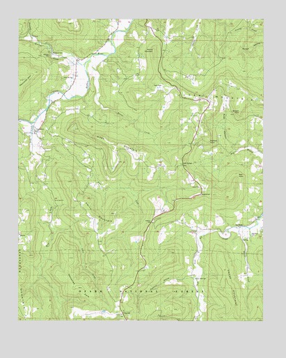
Parthenon, AR USGS Topographic Map
Click on map above to begin viewing in our Map Viewer.

This topographic map contains these locations and features:
Feature Name Type Latitude Longitude GNIS ID View Map
Asia PointCliffN35.9337°W93.1399°70473View Map
Brasel CreekStreamN35.9831°W93.2143°70802View Map
Coopers Bluff CemeteryCemeteryN35.8926°W93.1602°59337View Map
Coopers Bluff SchoolSchoolN35.8792°W93.1582°71227View Map
Cross Road SchoolSchoolN35.8779°W93.1977°76710View Map
CrossroadPopulated PlaceN35.8787°W93.1974°79310View Map
Diamond CavePopulated PlaceN35.9851°W93.2327°71383View Map
East Fork Shop CreekStreamN35.9481°W93.2435°71511View Map
Farmer CoveValleyN35.8929°W93.1588°71595View Map
Gum Spring SchoolSchoolN35.9401°W93.1657°71860View Map
Gum SpringsPopulated PlaceN35.9395°W93.1663°59336View Map
Henson CreekStreamN35.9812°W93.2168°71970View Map
Honey CreekStreamN35.9137°W93.1332°59338View Map
Jasper Fire - Mockingbird Hill SubstationBuildingN35.9641°W93.1526°2116628View Map
Jim Rush HollowValleyN35.9459°W93.1396°72189View Map
Judea MountainSummitN35.9717°W93.1760°72225View Map
Lone Beach ChurchChurchN35.9256°W93.2305°76646View Map
McElroy GapGapN35.9165°W93.1813°72592View Map
Meadows ParkFlatN35.8895°W93.2180°72623View Map
Morgan PointCliffN35.9612°W93.1368°72732View Map
Moss MountainSummitN35.9470°W93.2016°72742View Map
Newton CountyCivilN35.9200°W93.2179°69900View Map
Northern Arkansas Regional Medical Center Emergency Medical Service - Newton CountyBuildingN35.9632°W93.1534°2119170View Map
Panther CreekStreamN35.9909°W93.2438°72988View Map
ParthenonPopulated PlaceN35.9531°W93.2421°77959View Map
Parthenon Fire StationBuildingN35.9513°W93.2396°2116940View Map
Parthenon Post OfficePost OfficeN35.9521°W93.2416°84504View Map
Parthenon School (historical)SchoolN35.9506°W93.2380°69936View Map
Red RockPopulated PlaceN35.9145°W93.1355°73265View Map
Red Rock CemeteryCemeteryN35.9109°W93.1313°59339View Map
Right Fork Big CreekStreamN35.8754°W93.1607°59362View Map
Rocklick PointCliffN35.9498°W93.1538°73352View Map
Round MountainSummitN35.9859°W93.1818°73412View Map
Shop CreekStreamN35.9573°W93.2424°73560View Map
Smith MountainSummitN35.9129°W93.2113°73622View Map
Township of HudsonCivilN35.9403°W93.2406°69677View Map
Union Hill CemeteryCemeteryN35.9756°W93.2221°59333View Map
Union Hill SchoolSchoolN35.9767°W93.2227°73942View Map
West Fork Shop CreekStreamN35.9481°W93.2435°74068View Map

Note: Coordinates in the location and feature list above are referenced to NAD83 datum.


Copyright (C) 2008-2024 Ryan Niemi / Sunset Dynamics ... All Rights Reserved