TopoQuest Logo
Do you find TopoQuest useful?
Help keep TopoQuest running and adding new maps/features by donating!
Bitcoin:  19c7KJd3qBynnjoSw5npx9KScwjBe4ifkT
Litecoin:  LXs6TkuXGGXo1vDsWCkWVdjQX94eUKd6ui
Home View Maps Find Maps Find Places Resources & Links


Murray, Arkansas Topographic Map

USGS Map Title: Murray, AR
USGS Map MRC: 35093H3
DRG (GeoTIFF) Download: o35093h3.tif


Neighboring USGS Topographic Map Quads:


  Osage SW, AR  
36093A4
 

  Ponca, AR  
36093A3
 

  Jasper, AR  
36093A2
 

  Boxley, AR  
35093H4
 

  Murray, AR  
35093H3
 

  Parthenon, AR  
35093H2
 

  Fallsville, AR  
35093G4
 

  Swain, AR  
35093G3
 

  Deer, AR  
35093G2


Map MRC Location:

N36°
W94°
N36°
W93°
H8 H7 H6 H5 H4 H3 H2 H1
G8 G7 G6 G5 G4 G3 G2 G1
F8 F7 F6 F5 F4 F3 F2 F1
E8 E7 E6 E5 E4 E3 E2 E1
D8 D7 D6 D5 D4 D3 D2 D1
C8 C7 C6 C5 C4 C3 C2 C1
B8 B7 B6 B5 B4 B3 B2 B1
A8 A7 A6 A5 A4 A3 A2 A1
N35°
W94°
N35°
W93°

Murray, AR USGS 1:24K Topographic Map Preview:
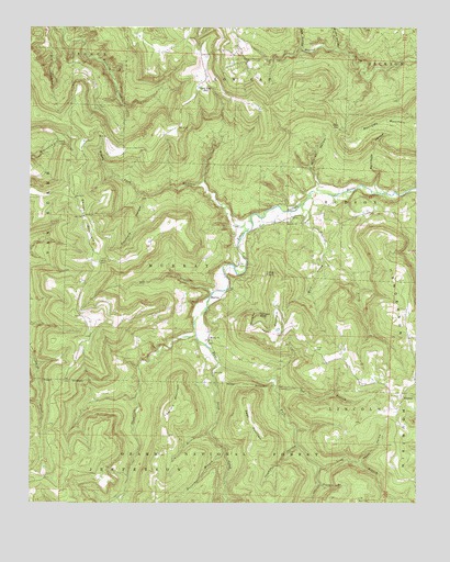
Murray, AR USGS Topographic Map
Click on map above to begin viewing in our Map Viewer.

This topographic map contains these locations and features:
Feature Name Type Latitude Longitude GNIS ID View Map
Abb CreekStreamN35.9306°W93.3152°70400View Map
Bean MountainSummitN35.8962°W93.3041°70542View Map
Beckham CreekStreamN35.9492°W93.3035°70593View Map
Buffalo ChurchChurchN35.9492°W93.2916°70910View Map
Busby HollowValleyN35.9949°W93.2761°70938View Map
Daniels MountainSummitN35.9020°W93.3268°71331View Map
Dog BranchStreamN35.9062°W93.2960°71398View Map
Douthard HollowValleyN35.9559°W93.3378°71411View Map
Dry CreekStreamN35.8767°W93.3457°71437View Map
East Fork Little Buffalo RiverStreamN35.9195°W93.3210°71507View Map
Gum BranchStreamN35.8937°W93.3166°71855View Map
Haunt HollowValleyN35.8861°W93.2684°71937View Map
Hoghead CreekStreamN35.9540°W93.2860°72037View Map
Horseshoe BranchStreamN35.8895°W93.3118°72084View Map
Keys GapGapN35.9737°W93.2752°72251View Map
Lick HollowValleyN35.9951°W93.2877°72347View Map
Long BranchStreamN35.8845°W93.2810°72469View Map
Long PointSummitN35.9351°W93.2952°72482View Map
Low GapLocaleN35.9862°W93.3185°72504View Map
Mount Sherman Volunteer Fire Department Shiloh SubstationBuildingN35.9935°W93.3203°2116825View Map
MurrayPopulated PlaceN35.9301°W93.3118°72819View Map
Murray ChurchChurchN35.9179°W93.3168°72821View Map
Murray School (historical)SchoolN35.9106°W93.3182°69934View Map
Panther BranchStreamN35.8798°W93.2810°72983View Map
Parthenon Volunteer Fire Wayton SubstationBuildingN35.9379°W93.2561°2116941View Map
Rainbow BluffCliffN35.9245°W93.3007°73227View Map
Reynolds MountainSummitN35.9748°W93.2505°73285View Map
Rich CemeteryCemeteryN35.8759°W93.2691°74479View Map
ShilohPopulated PlaceN35.9501°W93.3580°69939View Map
Shiloh CemeteryCemeteryN35.9384°W93.3532°73544View Map
Shiloh MountainSummitN35.9504°W93.3577°73547View Map
Shiloh Primitive Baptist ChurchChurchN35.9506°W93.3577°78350View Map
Shiloh School (historical)SchoolN35.9506°W93.3580°69940View Map
Silbey CoveValleyN35.9565°W93.3399°73579View Map
Snow CemeteryCemeteryN35.9156°W93.2824°73636View Map
Spring HollowValleyN35.9259°W93.3018°73674View Map
Stepp CreekStreamN35.9117°W93.3138°73696View Map
Taylor MountainSummitN35.9196°W93.2963°73835View Map
Taylor's Air StripAirportN35.8986°W93.2583°2650714View Map
Thomas CreekStreamN35.9190°W93.3210°73852View Map
Thomas HollowValleyN35.8895°W93.2882°73854View Map
Township of LincolnCivilN35.8971°W93.2687°69682View Map
Township of MurrayCivilN35.9373°W93.3295°69685View Map
Warhouse HollowValleyN35.9584°W93.2632°74004View Map
WaytonPopulated PlaceN35.9037°W93.2541°74029View Map
Wayton School (historical)SchoolN35.9001°W93.2557°69945View Map
West Prong Hoghead CreekStreamN35.9423°W93.2793°74081View Map
Wildcat HollowValleyN35.9634°W93.2841°74149View Map

Note: Coordinates in the location and feature list above are referenced to NAD83 datum.


Copyright (C) 2008-2024 Ryan Niemi / Sunset Dynamics ... All Rights Reserved