TopoQuest Logo
Do you find TopoQuest useful?
Help keep TopoQuest running and adding new maps/features by donating!
Bitcoin:  19c7KJd3qBynnjoSw5npx9KScwjBe4ifkT
Litecoin:  LXs6TkuXGGXo1vDsWCkWVdjQX94eUKd6ui
Home View Maps Find Maps Find Places Resources & Links


Hightogy, Alabama Topographic Map

USGS Map Title: Hightogy, AL
USGS Map MRC: 33088F1
DRG (GeoTIFF) Download: o33088f1.tif


Neighboring USGS Topographic Map Quads:


  Sulligent SW, AL  
33088G2
 

  Vernon, AL  
33088G1
 

  Bluff, AL  
33087G8
 

  Millport NW, AL  
33088F2
 

  Hightogy, AL  
33088F1
 

  Belk, AL  
33087F8
 

  Fernbank, AL  
33088E2
 

  Millport, AL  
33088E1
 

  Kennedy, AL  
33087E8


Map MRC Location:

N34°
W89°
N34°
W88°
H8 H7 H6 H5 H4 H3 H2 H1
G8 G7 G6 G5 G4 G3 G2 G1
F8 F7 F6 F5 F4 F3 F2 F1
E8 E7 E6 E5 E4 E3 E2 E1
D8 D7 D6 D5 D4 D3 D2 D1
C8 C7 C6 C5 C4 C3 C2 C1
B8 B7 B6 B5 B4 B3 B2 B1
A8 A7 A6 A5 A4 A3 A2 A1
N33°
W89°
N33°
W88°

Hightogy, AL USGS 1:24K Topographic Map Preview:
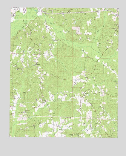
Hightogy, AL USGS Topographic Map
Click on map above to begin viewing in our Map Viewer.

This topographic map contains these locations and features:
Feature Name Type Latitude Longitude GNIS ID View Map
Bethel CemeteryCemeteryN33.7437°W88.0645°158438View Map
Bethel ChurchChurchN33.7443°W88.0664°114068View Map
Buck CreekStreamN33.7409°W88.0964°115124View Map
Canaan CemeteryCemeteryN33.6284°W88.0506°159032View Map
Christian Chapel CemeteryCemeteryN33.6779°W88.0892°158440View Map
Christian Chapel Church of ChristChurchN33.6773°W88.0892°116090View Map
CrossvillePopulated PlaceN33.7440°W88.0022°157928View Map
Crossville Fire and RescueBuildingN33.7450°W88.0054°2682876View Map
Faith ChapelChurchN33.6321°W88.1117°149428View Map
Hells CreekStreamN33.7384°W88.1039°119935View Map
Hells Creek Gas FieldOilfieldN33.7334°W88.0709°154879View Map
HightogyPopulated PlaceN33.6951°W88.0948°157983View Map
Hightogy ChurchChurchN33.6948°W88.0950°149430View Map
Hughes ChurchChurchN33.6679°W88.1209°132778View Map
KingvillePopulated PlaceN33.6676°W88.0406°156561View Map
Kingville ChurchChurchN33.6729°W88.0434°149431View Map
Lamar County Medical CenterHospitalN33.7498°W88.1186°132780View Map
Liberty CemeteryCemeteryN33.6343°W88.0242°158451View Map
Liberty ChurchChurchN33.6340°W88.0250°121553View Map
Little Hells CreekStreamN33.7129°W88.0328°121797View Map
Meadow Branch CemeteryCemeteryN33.6393°W88.0200°158453View Map
Meadow Branch ChurchChurchN33.6387°W88.0200°122613View Map
Mount Harmony Free Will Baptist ChurchChurchN33.6973°W88.0936°132791View Map
Mount Olive CemeteryCemeteryN33.6415°W88.0761°158458View Map
Mount Olive ChurchChurchN33.6415°W88.0756°123315View Map
Mount Zion Baptist ChurchChurchN33.6912°W88.1139°152531View Map
Mount Zion CemeteryCemeteryN33.6907°W88.1134°158460View Map
Mount Zion Gas FieldOilfieldN33.6759°W88.1084°154878View Map
New Canaan ChurchChurchN33.6271°W88.0520°123731View Map
Shiloh CemeteryCemeteryN33.6940°W88.0961°158472View Map
Shiloh United Methodist ChurchChurchN33.6946°W88.0959°132800View Map
South Carolina Baptist ChurchChurchN33.7054°W88.0881°153502View Map
South Carolina CemeteryCemeteryN33.7057°W88.0875°158474View Map
Temple Star CemeteryCemeteryN33.7307°W88.0031°158478View Map
Temple Star ChurchChurchN33.7309°W88.0028°127753View Map
Union ChapelChurchN33.7343°W88.0014°128272View Map
Union Chapel CemeteryCemeteryN33.7332°W88.0014°158479View Map
Vernon CemeteryCemeteryN33.7465°W88.1109°158480View Map
Walnut Grove CemeteryCemeteryN33.6490°W88.1084°132804View Map
Walnut Grove ChurchChurchN33.6490°W88.1073°128556View Map

Note: Coordinates in the location and feature list above are referenced to NAD83 datum.


Copyright (C) 2008-2025 Ryan Niemi / Sunset Dynamics ... All Rights Reserved