TopoQuest Logo
Do you find TopoQuest useful?
Help keep TopoQuest running and adding new maps/features by donating!
Bitcoin:  19c7KJd3qBynnjoSw5npx9KScwjBe4ifkT
Litecoin:  LXs6TkuXGGXo1vDsWCkWVdjQX94eUKd6ui
Home View Maps Find Maps Find Places Resources & Links


Millport, Alabama Topographic Map

USGS Map Title: Millport, AL
USGS Map MRC: 33088E1
DRG (GeoTIFF) Download: o33088e1.tif


Neighboring USGS Topographic Map Quads:


  Millport NW, AL  
33088F2
 

  Hightogy, AL  
33088F1
 

  Belk, AL  
33087F8
 

  Fernbank, AL  
33088E2
 

  Millport, AL  
33088E1
 

  Kennedy, AL  
33087E8
 

  Ethelsville, AL  
33088D2
 

  Reform, AL  
33088D1
 

  Palmetto, AL  
33087D8


Map MRC Location:

N34°
W89°
N34°
W88°
H8 H7 H6 H5 H4 H3 H2 H1
G8 G7 G6 G5 G4 G3 G2 G1
F8 F7 F6 F5 F4 F3 F2 F1
E8 E7 E6 E5 E4 E3 E2 E1
D8 D7 D6 D5 D4 D3 D2 D1
C8 C7 C6 C5 C4 C3 C2 C1
B8 B7 B6 B5 B4 B3 B2 B1
A8 A7 A6 A5 A4 A3 A2 A1
N33°
W89°
N33°
W88°

Millport, AL USGS 1:24K Topographic Map Preview:
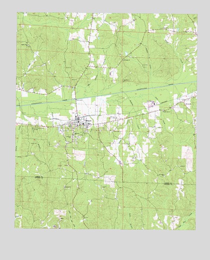
Millport, AL USGS Topographic Map
Click on map above to begin viewing in our Map Viewer.

This topographic map contains these locations and features:
Feature Name Type Latitude Longitude GNIS ID View Map
Bell CemeteryCemeteryN33.5068°W88.0775°113856View Map
Church CampLocaleN33.5582°W88.1106°116150View Map
Clear CreekStreamN33.5765°W88.0472°116222View Map
Cooper CreekStreamN33.5840°W88.0197°116583View Map
Crane CreekStreamN33.5704°W88.0436°116813View Map
Driver CreekStreamN33.5754°W88.0800°117482View Map
East Webster High SchoolSchoolN33.6215°W88.0806°705685View Map
Eatman CemeteryCemeteryN33.5493°W88.1147°117807View Map
Gentry CreekStreamN33.5707°W88.1217°118897View Map
Golden CreekStreamN33.5821°W88.0314°119093View Map
Gus Johnson BranchStreamN33.5748°W88.0884°119515View Map
Holly Grove CemeteryCemeteryN33.5648°W88.0561°120271View Map
Holly Grove SchoolSchoolN33.5551°W88.0847°120274View Map
Kennedy Gas FieldOilfieldN33.5904°W88.0084°154884View Map
Macedonia CemeteryCemeteryN33.5237°W88.0906°138748View Map
Macedonia ChurchChurchN33.5243°W88.0909°122164View Map
MillportPopulated PlaceN33.5634°W88.0814°122845View Map
Millport DivisionCivilN33.6074°W88.0966°165829View Map
Millport Fire DepartmentBuildingN33.5616°W88.0731°2682841View Map
Millport Gas FieldOilfieldN33.5793°W88.0689°154883View Map
Millport High School (historical)SchoolN33.5607°W88.0784°132789View Map
Millport Police DepartmentBuildingN33.5610°W88.0782°2752047View Map
Millport Post OfficePost OfficeN33.5624°W88.0817°2789108View Map
Mount Carmel CemeteryCemeteryN33.5312°W88.0220°158455View Map
Mount Carmel ChurchChurchN33.5318°W88.0225°123177View Map
Mount Carmel Gas FieldOilfieldN33.5293°W88.0320°154882View Map
Mount Pleasant CemeteryCemeteryN33.5859°W88.0511°123351View Map
Mount Pleasant ChurchChurchN33.5982°W88.0514°123370View Map
Nazarene ChurchChurchN33.5587°W88.1078°132795View Map
Oddfellows CemeteryCemeteryN33.5534°W88.0861°158463View Map
Payne Chapel CemeteryCemeteryN33.5571°W88.0578°124512View Map
Pleasant Grove CemeteryCemeteryN33.5696°W88.0234°158465View Map
Pleasant Grove ChurchChurchN33.5687°W88.0234°124961View Map
Pleasant Ridge CemeteryCemeteryN33.6059°W88.1170°158467View Map
Pleasant Ridge ChurchChurchN33.6059°W88.1173°153010View Map
Propst CreekStreamN33.5715°W88.1153°125301View Map
Rushing CreekStreamN33.5793°W88.0503°126019View Map
ShawPopulated PlaceN33.5065°W88.0942°126649View Map
Shelton BranchStreamN33.5646°W88.1195°126682View Map
South Lamar High SchoolSchoolN33.5612°W88.0356°149434View Map
Town of MillportCivilN33.5586°W88.0817°2406164View Map

Note: Coordinates in the location and feature list above are referenced to NAD83 datum.


Copyright (C) 2008-2025 Ryan Niemi / Sunset Dynamics ... All Rights Reserved