TopoQuest Logo
Do you find TopoQuest useful?
Help keep TopoQuest running and adding new maps/features by donating!
Bitcoin:  19c7KJd3qBynnjoSw5npx9KScwjBe4ifkT
Litecoin:  LXs6TkuXGGXo1vDsWCkWVdjQX94eUKd6ui
Home View Maps Find Maps Find Places Resources & Links


Kentland, Indiana Topographic Map

USGS Map Title: Kentland, IN
USGS Map MRC: 40087G4
DRG (GeoTIFF) Download: o40087g4.tif


Neighboring USGS Topographic Map Quads:


  Donovan, IL  
40087H5
 

  Morocco, IN  
40087H4
 

  Mount Ayr, IN  
40087H3
 

  Sheldon, IL  
40087G5
 

  Kentland, IN  
40087G4
 

  Goodland, IN  
40087G3
 

  Darrow, IL  
40087F5
 

  Earl Park, IN  
40087F4
 

  Wadena, IN  
40087F3


Map MRC Location:

N41°
W88°
N41°
W87°
H8 H7 H6 H5 H4 H3 H2 H1
G8 G7 G6 G5 G4 G3 G2 G1
F8 F7 F6 F5 F4 F3 F2 F1
E8 E7 E6 E5 E4 E3 E2 E1
D8 D7 D6 D5 D4 D3 D2 D1
C8 C7 C6 C5 C4 C3 C2 C1
B8 B7 B6 B5 B4 B3 B2 B1
A8 A7 A6 A5 A4 A3 A2 A1
N40°
W88°
N40°
W87°

Kentland, IN USGS 1:24K Topographic Map Preview:
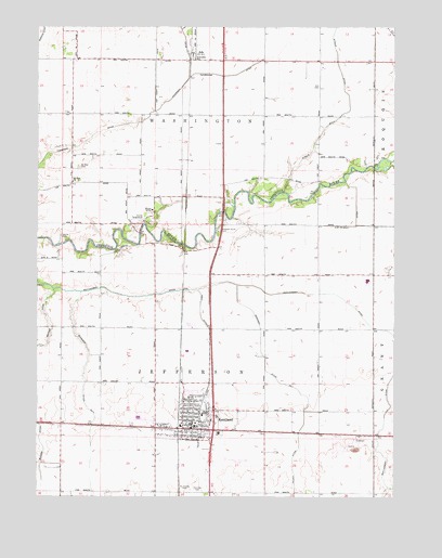
Kentland, IN USGS Topographic Map
Click on map above to begin viewing in our Map Viewer.

This topographic map contains these locations and features:
Feature Name Type Latitude Longitude GNIS ID View Map
AdePopulated PlaceN40.8684°W87.4447°430017View Map
Ade McCray DitchCanalN40.8245°W87.3886°430019View Map
Bonham DitchCanalN40.7753°W87.4997°431319View Map
Buswell CemeteryCemeteryN40.8375°W87.4853°439736View Map
Doran CemeteryCemeteryN40.8194°W87.4916°433644View Map
Fairlawn CemeteryCemeteryN40.7523°W87.4436°434302View Map
Hambridge DitchCanalN40.8623°W87.4334°435629View Map
Kent DitchCanalN40.7623°W87.4436°437253View Map
KentlandPopulated PlaceN40.7703°W87.4453°437256View Map
Kentland Elementary SchoolSchoolN40.7698°W87.4489°447317View Map
Kentland Fire DepartmentBuildingN40.7761°W87.4427°2625903View Map
Kentland Municipal AirportAirportN40.7598°W87.4349°449224View Map
Kentland Police DepartmentBuildingN40.7704°W87.4455°2758284View Map
Montgomery DitchCanalN40.8061°W87.4242°439365View Map
Morrison Ditch Number OneCanalN40.7856°W87.4203°439460View Map
Morrison Ditch Number TwoCanalN40.7714°W87.4797°439461View Map
Mount Zion ChurchChurchN40.8339°W87.4878°439774View Map
NewtonPopulated PlaceN40.7667°W87.3861°446686View Map
Newton County QuarryMineN40.7636°W87.3883°2649601View Map
Newton County Sheriff's OfficeBuildingN40.7683°W87.4445°2758115View Map
Pleasant Grove CemeteryCemeteryN40.8212°W87.4362°441249View Map
Saint Josephs CemeteryCemeteryN40.7519°W87.4462°442633View Map
South Newton Junior and Senior High SchoolSchoolN40.7723°W87.4420°447318View Map
Strole DitchCanalN40.8736°W87.3964°444275View Map
Thompson DitchCanalN40.8575°W87.4514°444719View Map
Town of KentlandCivilN40.7740°W87.4465°2397015View Map
Township of JeffersonCivilN40.7803°W87.4513°453492View Map
Township of WashingtonCivilN40.8674°W87.4566°454009View Map

Note: Coordinates in the location and feature list above are referenced to NAD83 datum.


Copyright (C) 2008-2024 Ryan Niemi / Sunset Dynamics ... All Rights Reserved