TopoQuest Logo
Do you find TopoQuest useful?
Help keep TopoQuest running and adding new maps/features by donating!
Bitcoin:  19c7KJd3qBynnjoSw5npx9KScwjBe4ifkT
Litecoin:  LXs6TkuXGGXo1vDsWCkWVdjQX94eUKd6ui
Home View Maps Find Maps Find Places Resources & Links


Sheldon, Illinois Topographic Map

USGS Map Title: Sheldon, IL
USGS Map MRC: 40087G5
DRG (GeoTIFF) Download: o40087g5.tif


Neighboring USGS Topographic Map Quads:


  Beaverville, IL  
40087H6
 

  Donovan, IL  
40087H5
 

  Morocco, IN  
40087H4
 

  Watseka, IL  
40087G6
 

  Sheldon, IL  
40087G5
 

  Kentland, IN  
40087G4
 

  Milford, IL  
40087F6
 

  Darrow, IL  
40087F5
 

  Earl Park, IN  
40087F4


Map MRC Location:

N41°
W88°
N41°
W87°
H8 H7 H6 H5 H4 H3 H2 H1
G8 G7 G6 G5 G4 G3 G2 G1
F8 F7 F6 F5 F4 F3 F2 F1
E8 E7 E6 E5 E4 E3 E2 E1
D8 D7 D6 D5 D4 D3 D2 D1
C8 C7 C6 C5 C4 C3 C2 C1
B8 B7 B6 B5 B4 B3 B2 B1
A8 A7 A6 A5 A4 A3 A2 A1
N40°
W88°
N40°
W87°

Sheldon, IL USGS 1:24K Topographic Map Preview:
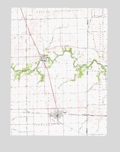
Sheldon, IL USGS Topographic Map
Click on map above to begin viewing in our Map Viewer.

This topographic map contains these locations and features:
Feature Name Type Latitude Longitude GNIS ID View Map
Baird DitchCanalN40.8725°W87.5170°430416View Map
Blackston BranchStreamN40.8284°W87.5639°404528View Map
Bowton DitchCanalN40.7631°W87.5106°431414View Map
Clark School (historical)SchoolN40.8064°W87.5581°1719346View Map
Concord Fire Protection DistrictBuildingN40.8267°W87.5819°2682564View Map
Eastburn Ditch Number 1CanalN40.7534°W87.6136°424857View Map
Eastburn Ditch Number 2CanalN40.7681°W87.6128°424858View Map
EffnerPopulated PlaceN40.7706°W87.5261°407810View Map
EffnerPopulated PlaceN40.7706°W87.5253°447634View Map
Gaffield CemeteryCemeteryN40.8168°W87.5885°408831View Map
Gaffield CreekStreamN40.8164°W87.5917°408832View Map
Hesperian School (historical)SchoolN40.7617°W87.5942°1719353View Map
IroquoisPopulated PlaceN40.8275°W87.5820°410924View Map
Iroquois Post OfficePost OfficeN40.8262°W87.5819°2741203View Map
Liberty CemeteryCemeteryN40.8379°W87.5530°411992View Map
Liberty School (historical)SchoolN40.8373°W87.5461°1719334View Map
Morris Chapel CemeteryCemeteryN40.8358°W87.5264°413840View Map
North Sheldon South Concord DitchCanalN40.8042°W87.5434°414669View Map
Rhode Island School (historical)SchoolN40.7978°W87.5909°1719439View Map
S Garrard DitchCanalN40.8720°W87.5059°442437View Map
SheldonPopulated PlaceN40.7692°W87.5639°418337View Map
Sheldon CemeteryCemeteryN40.7617°W87.5634°418338View Map
Sheldon District Fire DepartmentBuildingN40.7684°W87.5638°2681705View Map
Sheldon DitchCanalN40.7820°W87.5242°443350View Map
Sheldon Ditch Number 1CanalN40.7845°W87.5272°425476View Map
Sheldon Elementary SchoolSchoolN40.7698°W87.5723°1815581View Map
Sheldon Emergency Medical ServicesBuildingN40.7698°W87.5635°2673919View Map
Sheldon High SchoolSchoolN40.7698°W87.5728°1815582View Map
Sheldon Police DepartmentBuildingN40.7703°W87.5643°2756947View Map
Tipton FarmsLocaleN40.8353°W87.6056°2742763View Map
Township of ConcordCivilN40.8201°W87.5895°428838View Map
Village of IroquoisCivilN40.8287°W87.5846°2398275View Map
Village of SheldonCivilN40.7710°W87.5658°2399797View Map
WebsterPopulated PlaceN40.7736°W87.6039°423295View Map
West Union School (historical)SchoolN40.8720°W87.5436°1719376View Map
Whaley DitchCanalN40.8470°W87.5178°445876View Map
Youngs School (historical)SchoolN40.8492°W87.5959°1719378View Map
Zoomer FieldAirportN40.7913°W87.5592°427804View Map

Note: Coordinates in the location and feature list above are referenced to NAD83 datum.


Copyright (C) 2008-2024 Ryan Niemi / Sunset Dynamics ... All Rights Reserved