TopoQuest Logo
Do you find TopoQuest useful?
Help keep TopoQuest running and adding new maps/features by donating!
Bitcoin:  19c7KJd3qBynnjoSw5npx9KScwjBe4ifkT
Litecoin:  LXs6TkuXGGXo1vDsWCkWVdjQX94eUKd6ui
Home View Maps Find Maps Find Places Resources & Links


Barcus Peak, Wyoming Topographic Map

USGS Map Title: Barcus Peak, WY
USGS Map MRC: 41106B5
DRG (GeoTIFF) Download: o41106b5.tif


Neighboring USGS Topographic Map Quads:


  Cow Creek, WY  
41106C6
 

  Ryan Park, WY  
41106C5
 

  Phantom Lake, WY  
41106C4
 

  Gunst Reservoir, WY  
41106B6
 

  Barcus Peak, WY  
41106B5
 

  Overlook Hill, WY  
41106B4
 

  Blackhall Mountain, WY  
41106A6
 

  Trent Creek, WY  
41106A5
 

  Elkhorn Point, WY  
41106A4


Map MRC Location:

N42°
W107°
N42°
W106°
H8 H7 H6 H5 H4 H3 H2 H1
G8 G7 G6 G5 G4 G3 G2 G1
F8 F7 F6 F5 F4 F3 F2 F1
E8 E7 E6 E5 E4 E3 E2 E1
D8 D7 D6 D5 D4 D3 D2 D1
C8 C7 C6 C5 C4 C3 C2 C1
B8 B7 B6 B5 B4 B3 B2 B1
A8 A7 A6 A5 A4 A3 A2 A1
N41°
W107°
N41°
W106°

Barcus Peak, WY USGS 1:24K Topographic Map Preview:
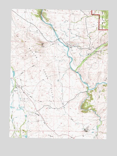
Barcus Peak, WY USGS Topographic Map
Click on map above to begin viewing in our Map Viewer.

This topographic map contains these locations and features:
Feature Name Type Latitude Longitude GNIS ID View Map
A Bar A Ranch AirportAirportN41.1627°W106.5605°1608990View Map
Addison GulchValleyN41.1516°W106.6245°1597686View Map
Bacus DitchCanalN41.2147°W106.5639°1597862View Map
Barcus CreekStreamN41.1936°W106.5498°1597920View Map
Barcus PeakSummitN41.2161°W106.5870°1597921View Map
Bear CreekStreamN41.1316°W106.5128°1597992View Map
Bear GulchValleyN41.1802°W106.5042°1598009View Map
Beaver Creek HillsSummitN41.2044°W106.5986°1598068View Map
Beaver Creek SchoolSchoolN41.1705°W106.6211°1598070View Map
Big CreekStreamN41.1730°W106.5250°1598135View Map
Big HollowValleyN41.1836°W106.6198°1598154View Map
Big Hollow GulchValleyN41.1689°W106.6142°1598155View Map
Big SpringSpringN41.1814°W106.5634°1598171View Map
Bull CanyonValleyN41.1327°W106.5234°1598478View Map
Bull CreekStreamN41.1419°W106.5078°1598479View Map
Coyote HillSummitN41.1277°W106.5739°1598990View Map
Fingerle HollowValleyN41.1833°W106.6198°1599702View Map
French CreekStreamN41.1911°W106.5434°1599859View Map
French Creek RanchLocaleN41.2100°W106.5175°1599864View Map
Golden Clover MineMineN41.1541°W106.5736°1599965View Map
Golden Clover Number 1 DamDamN41.1533°W106.6123°1606092View Map
Golden Clover Reservoir Number 1ReservoirN41.1531°W106.6106°1605286View Map
Golden Clover Reservoir Number 2ReservoirN41.1525°W106.6111°1605287View Map
Homestead DrawValleyN41.1497°W106.6059°1600371View Map
Jenkins PeakSummitN41.2097°W106.5111°1600600View Map
Jenkins RanchLocaleN41.2077°W106.5239°1600602View Map
Little Beaver CreekStreamN41.1750°W106.6195°1600948View Map
Little CreekStreamN41.1944°W106.5395°1600966View Map
Platt CemeteryCemeteryN41.1751°W106.6174°1602209View Map
Platt RanchLocaleN41.1736°W106.6170°1602211View Map
Platt Ranch Airport (historical)AirportN41.1618°W106.6010°1608991View Map
Reservoir CreekStreamN41.1697°W106.6228°1602500View Map
Rocky Point DitchCanalN41.2200°W106.5470°1602613View Map
Rocky Point DitchCanalN41.2177°W106.5561°1602614View Map
Rollman ReservoirReservoirN41.1545°W106.6232°1602623View Map
Sanger DrawValleyN41.2191°W106.5678°1602731View Map
Sanger RanchLocaleN41.2144°W106.5525°1602732View Map
School CreekStreamN41.2200°W106.5645°1602767View Map
Slims DrawValleyN41.1764°W106.5134°1602987View Map
Summit DamDamN41.1266°W106.6023°1606033View Map
Summit ReservoirReservoirN41.1262°W106.6035°1603436View Map
Toothaker DamDamN41.1866°W106.6206°1606031View Map
Toothaker ReservoirReservoirN41.1871°W106.6207°1606032View Map

Note: Coordinates in the location and feature list above are referenced to NAD83 datum.


Copyright (C) 2008-2025 Ryan Niemi / Sunset Dynamics ... All Rights Reserved