TopoQuest Logo
Do you find TopoQuest useful?
Help keep TopoQuest running and adding new maps/features by donating!
Bitcoin:  19c7KJd3qBynnjoSw5npx9KScwjBe4ifkT
Litecoin:  LXs6TkuXGGXo1vDsWCkWVdjQX94eUKd6ui
Home View Maps Find Maps Find Places Resources & Links


Kokomo, Mississippi Topographic Map

USGS Map Title: Kokomo, MS
USGS Map MRC: 31090B1
DRG (GeoTIFF) Download: o31090b1.tif


Neighboring USGS Topographic Map Quads:


  Jayess, MS  
31090C2
 

  Darbun, MS  
31090C1
 

  Morgantown, MS  
31089C8
 

  Mesa, MS  
31090B2
 

  Kokomo, MS  
31090B1
 

  Sandy Hook NW, MS  
31089B8
 

  Tylertown, MS  
31090A2
 

  Tylertown SE, MS  
31090A1
 

  Dexter, MS  
31089A8


Map MRC Location:

N32°
W91°
N32°
W90°
H8 H7 H6 H5 H4 H3 H2 H1
G8 G7 G6 G5 G4 G3 G2 G1
F8 F7 F6 F5 F4 F3 F2 F1
E8 E7 E6 E5 E4 E3 E2 E1
D8 D7 D6 D5 D4 D3 D2 D1
C8 C7 C6 C5 C4 C3 C2 C1
B8 B7 B6 B5 B4 B3 B2 B1
A8 A7 A6 A5 A4 A3 A2 A1
N31°
W91°
N31°
W90°

Kokomo, MS USGS 1:24K Topographic Map Preview:
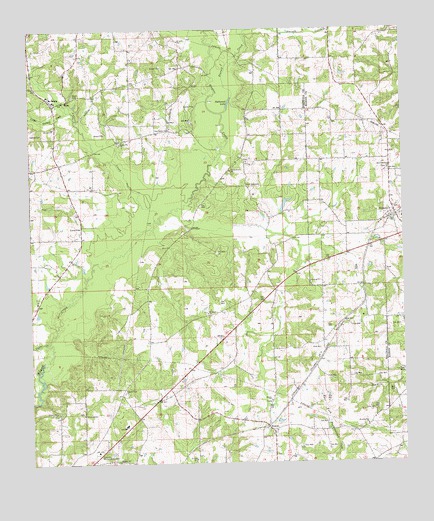
Kokomo, MS USGS Topographic Map
Click on map above to begin viewing in our Map Viewer.

This topographic map contains these locations and features:
Feature Name Type Latitude Longitude GNIS ID View Map
4th District Volunteer Fire Department Station 2BuildingN31.2291°W90.1163°2667873View Map
Barrett DamDamN31.1285°W90.0351°680584View Map
Boyd CemeteryCemeteryN31.2313°W90.1106°667489View Map
Brandon Bay ChurchChurchN31.1360°W90.0126°667520View Map
China GrovePopulated PlaceN31.2127°W90.0534°687115View Map
China Grove CemeteryCemeteryN31.2085°W90.0579°709238View Map
China Grove Church of GodChurchN31.2119°W90.0521°668393View Map
Darbun CreekStreamN31.2488°W90.0545°669107View Map
Dillon Hill Church of God in ChristChurchN31.1392°W90.1080°669270View Map
Faith TabernacleChurchN31.2052°W90.0531°669897View Map
Hillcrest Memorial GardensCemeteryN31.1280°W90.1037°671221View Map
KnoxoPopulated PlaceN31.1355°W90.0462°691989View Map
Knoxo Baptist ChurchChurchN31.1338°W90.0451°2596889View Map
Knoxo CemeteryCemeteryN31.1330°W90.0431°709249View Map
Knoxo Church of God in ChristChurchN31.1432°W90.0452°672209View Map
KokomoPopulated PlaceN31.1974°W90.0029°672210View Map
Kokomo Baptist ChurchChurchN31.1952°W90.0003°2596617View Map
Kokomo CemeteryCemeteryN31.1993°W90.0017°710585View Map
Kokomo Post OfficePost OfficeN31.1953°W90.0028°2596439View Map
Kokomo SchoolSchoolN31.1957°W90.0001°672211View Map
Little Varnell CreekStreamN31.2266°W90.1123°672706View Map
Magees Creek ChurchChurchN31.1455°W90.0943°673061View Map
MelisPopulated PlaceN31.2299°W90.1126°692064View Map
New Bethel ChurchChurchN31.2216°W90.0793°674573View Map
New Damascus CemeteryCemeteryN31.2099°W90.0054°710587View Map
New Damascus ChurchChurchN31.2093°W90.0048°674609View Map
Packwood LakeLakeN31.2285°W90.0595°675374View Map
Pilgrim Lake DamDamN31.2002°W90.0384°680605View Map
Pyramid Unicom Airport (historical)AirportN31.2021°W90.0226°680311View Map
Saint James ChurchChurchN31.1682°W90.0662°677029View Map
SalemPopulated PlaceN31.2299°W90.1173°692201View Map
Salem Attendance CenterSchoolN31.2307°W90.1176°709259View Map
Salem Baptist ChurchChurchN31.2312°W90.1188°687125View Map
Spence CemeteryCemeteryN31.2202°W90.1206°678049View Map
Stovall CreekStreamN31.2260°W90.0618°678324View Map
Summers Poultry FarmLocaleN31.2458°W90.0247°2664462View Map
Supervisor District 2CivilN31.1443°W90.0619°712116View Map
Union CreekStreamN31.1599°W90.1195°679072View Map
Varnell CreekStreamN31.1946°W90.0837°679193View Map
Walthall CountyCivilN31.1484°W90.1061°695794View Map

Note: Coordinates in the location and feature list above are referenced to NAD83 datum.


Copyright (C) 2008-2025 Ryan Niemi / Sunset Dynamics ... All Rights Reserved