TopoQuest Logo
Do you find TopoQuest useful?
Help keep TopoQuest running and adding new maps/features by donating!
Bitcoin:  19c7KJd3qBynnjoSw5npx9KScwjBe4ifkT
Litecoin:  LXs6TkuXGGXo1vDsWCkWVdjQX94eUKd6ui
Home View Maps Find Maps Find Places Resources & Links


Newlight, Louisiana Topographic Map

USGS Map Title: Newlight, LA
USGS Map MRC: 32091A4
DRG (GeoTIFF) Download: o32091a4.tif


Neighboring USGS Topographic Map Quads:


  Crowville, LA  
32091B5
 

  Tensas Bluff, LA  
32091B4
 

  Westwood, LA  
32091B3
 

  Como, LA  
32091A5
 

  Newlight, LA  
32091A4
 

  Saranac, LA  
32091A3
 

  Oakley, LA  
31091H5
 

  Gretna Green, LA  
31091H4
 

  Lake Bruin, LA  
31091H3


Map MRC Location:

N33°
W92°
N33°
W91°
H8 H7 H6 H5 H4 H3 H2 H1
G8 G7 G6 G5 G4 G3 G2 G1
F8 F7 F6 F5 F4 F3 F2 F1
E8 E7 E6 E5 E4 E3 E2 E1
D8 D7 D6 D5 D4 D3 D2 D1
C8 C7 C6 C5 C4 C3 C2 C1
B8 B7 B6 B5 B4 B3 B2 B1
A8 A7 A6 A5 A4 A3 A2 A1
N32°
W92°
N32°
W91°

Newlight, LA USGS 1:24K Topographic Map Preview:
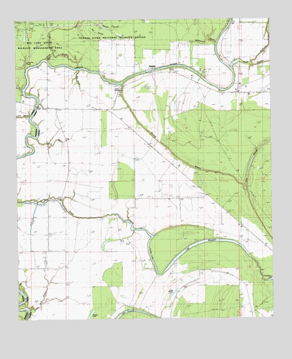
Newlight, LA USGS Topographic Map
Click on map above to begin viewing in our Map Viewer.

This topographic map contains these locations and features:
Feature Name Type Latitude Longitude GNIS ID View Map
Bengal SloughGutN32.1221°W91.4579°532936View Map
Bieler BayouGutN32.0493°W91.4896°553627View Map
Big BayouGutN32.0943°W91.4646°533022View Map
Big Roaring BayouStreamN32.0960°W91.4968°533102View Map
Big SloughGutN32.1185°W91.4593°533106View Map
Caney BayouGutN32.0749°W91.4793°533723View Map
Ferry Newlight LandingPopulated PlaceN32.1040°W91.4293°543201View Map
Glade Bayou LandingPopulated PlaceN32.1029°W91.3932°543238View Map
Glade Bayou Oil FieldOilfieldN32.0913°W91.3787°549309View Map
Hopaka LakeLakeN32.0371°W91.4401°554749View Map
Lake Formosa Oil FieldOilfieldN32.0099°W91.4473°1629526View Map
Lake MarydaleLakeN32.0299°W91.4148°555245View Map
Lake MiseryLakeN32.0120°W91.4227°555335View Map
Little Roaring BayouStreamN32.1049°W91.4946°536604View Map
Long BayouStreamN32.0852°W91.4932°556514View Map
Magnolia ChurchChurchN32.1040°W91.4243°536842View Map
Magnolia SchoolSchoolN32.1038°W91.4243°536846View Map
Marydale PlantationLocaleN32.0321°W91.3904°536932View Map
McPherson BayouGutN32.1154°W91.4146°537017View Map
Mound BayouGutN32.0635°W91.4140°537273View Map
NewlightPopulated PlaceN32.1035°W91.4335°555492View Map
Newlight OilOilfieldN32.1213°W91.4412°537663View Map
North Lake Marydale Oil FieldOilfieldN32.0699°W91.4282°549344View Map
Pecan LandingPopulated PlaceN32.1027°W91.4135°543569View Map
Pecan Landing Oil FieldOilfieldN32.1113°W91.4168°549349View Map
Remolina LandingPopulated PlaceN32.1102°W91.4021°543616View Map
Sandy BayouGutN32.1099°W91.4829°539150View Map
Skeeter LakeLakeN32.0009°W91.4651°556057View Map
Tensas Parish Fire District 1 Station 5BuildingN32.0953°W91.3906°2673011View Map
Three Buck BayouGutN32.0182°W91.4868°539908View Map
Turkey LakeLakeN32.0352°W91.4323°556283View Map
West Newlight Oil and Gas FieldOilfieldN32.1168°W91.4993°549384View Map

Note: Coordinates in the location and feature list above are referenced to NAD83 datum.


Copyright (C) 2008-2024 Ryan Niemi / Sunset Dynamics ... All Rights Reserved