TopoQuest Logo
Do you find TopoQuest useful?
Help keep TopoQuest running and adding new maps/features by donating!
Bitcoin:  19c7KJd3qBynnjoSw5npx9KScwjBe4ifkT
Litecoin:  LXs6TkuXGGXo1vDsWCkWVdjQX94eUKd6ui
Home View Maps Find Maps Find Places Resources & Links


Rock Pile Mountain, Missouri Topographic Map

USGS Map Title: Rock Pile Mountain, MO
USGS Map MRC: 37090D4
DRG (GeoTIFF) Download: o37090d4.tif


Neighboring USGS Topographic Map Quads:


  Lake Killarney, MO  
37090E5
 

  Rhodes Mountain, MO  
37090E4
 

  Fredericktown, MO  
37090E3
 

  Des Arc NE, MO  
37090D5
 

  Rock Pile Mountain, MO  
37090D4
 

  Cherokee Pass, MO  
37090D3
 

  Brunot, MO  
37090C5
 

  Coldwater, MO  
37090C4
 

  Cascade, MO  
37090C3


Map MRC Location:

N38°
W91°
N38°
W90°
H8 H7 H6 H5 H4 H3 H2 H1
G8 G7 G6 G5 G4 G3 G2 G1
F8 F7 F6 F5 F4 F3 F2 F1
E8 E7 E6 E5 E4 E3 E2 E1
D8 D7 D6 D5 D4 D3 D2 D1
C8 C7 C6 C5 C4 C3 C2 C1
B8 B7 B6 B5 B4 B3 B2 B1
A8 A7 A6 A5 A4 A3 A2 A1
N37°
W91°
N37°
W90°

Rock Pile Mountain, MO USGS 1:24K Topographic Map Preview:
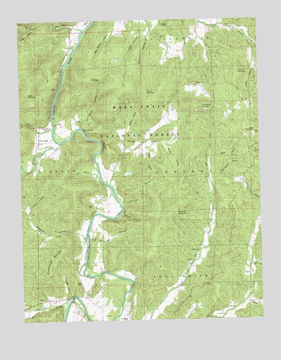
Rock Pile Mountain, MO USGS Topographic Map
Click on map above to begin viewing in our Map Viewer.

This topographic map contains these locations and features:
Feature Name Type Latitude Longitude GNIS ID View Map
Arnett MountainSummitN37.4703°W90.4343°748614View Map
Ballew HollowValleyN37.3823°W90.3837°753464View Map
Berry CemeteryCemeteryN37.4089°W90.4646°753563View Map
Bill Smith HollowValleyN37.4553°W90.4685°753575View Map
Black MountainSummitN37.4691°W90.4960°748883View Map
Bratt HollowValleyN37.4428°W90.4015°753567View Map
Brewington CemeteryCemeteryN37.3762°W90.4457°753556View Map
Brushy HollowValleyN37.4464°W90.4451°753573View Map
Captain CreekStreamN37.4303°W90.4521°749210View Map
Captain Creek CemeteryCemeteryN37.4495°W90.4396°753570View Map
Captain Creek SchoolSchoolN37.4492°W90.4376°749211View Map
Cave BranchStreamN37.4226°W90.4473°753564View Map
Cedar MountainSummitN37.4531°W90.3760°749308View Map
Cobalt HollowValleyN37.4473°W90.4379°753569View Map
Copper MountainSummitN37.4781°W90.3857°753579View Map
Cox CemeteryCemeteryN37.4000°W90.4109°753554View Map
Cox Spring HollowValleyN37.4828°W90.3776°753469View Map
Dark HollowValleyN37.4962°W90.4654°749570View Map
Dry CreekStreamN37.3759°W90.3962°749713View Map
Dug HillSummitN37.3901°W90.4712°753558View Map
East CemeteryCemeteryN37.3931°W90.4657°753557View Map
FaroPopulated PlaceN37.4473°W90.4376°749903View Map
Fox Mine HollowValleyN37.4198°W90.4968°753576View Map
Francis CemeteryCemeteryN37.4737°W90.4073°753578View Map
French MillsPopulated PlaceN37.4559°W90.4893°749998View Map
Greens Chapel (historical)ChurchN37.4198°W90.4618°736406View Map
Greens Chapel School (historical)SchoolN37.4123°W90.4732°736407View Map
Gregory CemeteryCemeteryN37.4039°W90.4076°753555View Map
Hassler BluffCliffN37.4984°W90.4218°753581View Map
Henry Gaines Lake DamDamN37.4317°W90.3835°764455View Map
Hicks HollowValleyN37.3959°W90.4585°753117View Map
Jackson HollowValleyN37.4089°W90.4665°753553View Map
Jewett CemeteryCemeteryN37.3775°W90.4968°753560View Map
Jones HollowValleyN37.4828°W90.3776°753468View Map
Jordan HollowValleyN37.4978°W90.4923°753552View Map
King SchoolSchoolN37.4512°W90.4918°750615View Map
Leatherwood CreekStreamN37.3814°W90.4771°750671View Map
Lee BluffCliffN37.4484°W90.4560°753571View Map
Lewis HollowValleyN37.4342°W90.4590°753572View Map
Little Grass MountainSummitN37.4628°W90.4046°750769View Map
Little Rock CreekStreamN37.4545°W90.4821°750795View Map
Lower Rock CreekStreamN37.4962°W90.4654°750886View Map
Marble CreekStreamN37.4487°W90.4785°750925View Map
Marlow MountainSummitN37.4759°W90.4618°750939View Map
Marsh CreekPopulated PlaceN37.4173°W90.4646°750942View Map
Marsh CreekStreamN37.4101°W90.4662°750943View Map
Miller CemeteryCemeteryN37.4228°W90.4626°753565View Map
Mine BranchStreamN37.4959°W90.4307°753583View Map
Mining HollowValleyN37.4470°W90.4335°753568View Map
Mount Pisgah ChurchChurchN37.3767°W90.3954°755586View Map
Mount Pisgah School (historical)SchoolN37.3781°W90.3948°736408View Map
Pig Pen GapGapN37.4919°W90.4252°738450View Map
Polly HollowValleyN37.4995°W90.4321°753582View Map
Rock Pile MountainSummitN37.4209°W90.4207°751926View Map
Rockpile Mountain WildernessReserveN37.4274°W90.4234°754364View Map
Sam Griffths HollowValleyN37.4348°W90.4015°753566View Map
Shoemaker CemeteryCemeteryN37.4562°W90.4859°753577View Map
Skaggs Lake DamDamN37.3817°W90.3801°765170View Map
Stacy HollowValleyN37.3839°W90.4771°753559View Map
Stumbeaugh MountainSummitN37.4053°W90.4773°753561View Map
Sulfur HollowValleyN37.3962°W90.3809°753465View Map
The Fish TrapChannelN37.4548°W90.4676°753574View Map
Trace Creek School (historical)SchoolN37.4139°W90.4035°752572View Map
Turkey Pen HollowValleyN37.4192°W90.4485°753562View Map
Wide FordPopulated PlaceN37.4314°W90.4554°752878View Map
Willow CreekStreamN37.4995°W90.4076°753580View Map

Note: Coordinates in the location and feature list above are referenced to NAD83 datum.


Copyright (C) 2008-2025 Ryan Niemi / Sunset Dynamics ... All Rights Reserved