TopoQuest Logo
Do you find TopoQuest useful?
Help keep TopoQuest running and adding new maps/features by donating!
Bitcoin:  19c7KJd3qBynnjoSw5npx9KScwjBe4ifkT
Litecoin:  LXs6TkuXGGXo1vDsWCkWVdjQX94eUKd6ui
Home View Maps Find Maps Find Places Resources & Links


Laurinburg, North Carolina Topographic Map

USGS Map Title: Laurinburg, NC
USGS Map MRC: 34079G4
DRG (GeoTIFF) Download: o34079g4.tif


Neighboring USGS Topographic Map Quads:


  Marston, NC  
34079H5
 

  Silver Hill, NC  
34079H4
 

  Wagram, NC  
34079H3
 

  Gibson, NC  
34079G5
 

  Laurinburg, NC  
34079G4
 

  Wakulla, NC  
34079G3
 

  McColl, SC  
34079F5
 

  Johns, NC  
34079F4
 

  Maxton, NC  
34079F3


Map MRC Location:

N35°
W80°
N35°
W79°
H8 H7 H6 H5 H4 H3 H2 H1
G8 G7 G6 G5 G4 G3 G2 G1
F8 F7 F6 F5 F4 F3 F2 F1
E8 E7 E6 E5 E4 E3 E2 E1
D8 D7 D6 D5 D4 D3 D2 D1
C8 C7 C6 C5 C4 C3 C2 C1
B8 B7 B6 B5 B4 B3 B2 B1
A8 A7 A6 A5 A4 A3 A2 A1
N34°
W80°
N34°
W79°

Laurinburg, NC USGS 1:24K Topographic Map Preview:
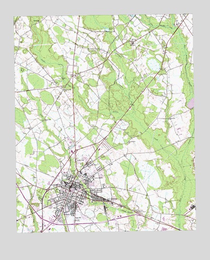
Laurinburg, NC USGS Topographic Map
Click on map above to begin viewing in our Map Viewer.

This topographic map contains these locations and features:
Feature Name Type Latitude Longitude GNIS ID View Map
Baidge CreekStreamN34.7502°W79.4864°979984View Map
Bel AirPopulated PlaceN34.7821°W79.4434°1005400View Map
Carolina ParkPopulated PlaceN34.7677°W79.4792°1005394View Map
Central Elementary SchoolSchoolN34.7707°W79.4606°1007027View Map
Chapel Hill SchoolSchoolN34.8149°W79.4795°983026View Map
City of LaurinburgCivilN34.7596°W79.4781°2404892View Map
College Park NorthPopulated PlaceN34.7779°W79.4470°1005397View Map
College Park SouthPopulated PlaceN34.7529°W79.4895°1005407View Map
Cool Spring SchoolSchoolN34.8552°W79.4425°983487View Map
Covington CemeteryCemeteryN34.7621°W79.4150°983627View Map
Covington Street Elementary SchoolSchoolN34.7740°W79.4692°1007026View Map
East LaurinburgPopulated PlaceN34.7713°W79.4437°1020084View Map
East Laurinburg Center for Exceptional ChildrenSchoolN34.7704°W79.4475°1007028View Map
Evens Grove ChurchChurchN34.8013°W79.4214°984865View Map
Gibson MillPopulated PlaceN34.8390°W79.4673°1020429View Map
Glen AcresPopulated PlaceN34.7571°W79.4695°1005406View Map
Glynn FieldsPopulated PlaceN34.7871°W79.4414°1005399View Map
Hammon HeightsPopulated PlaceN34.7640°W79.4650°1005389View Map
Hillside CemeteryCemeteryN34.7846°W79.4623°986835View Map
Holly SquareLocaleN34.7518°W79.4767°1007585View Map
Johnson Middle SchoolSchoolN34.7938°W79.4231°1007029View Map
Jones PondReservoirN34.7517°W79.4907°998125View Map
Jones Pond DamDamN34.7518°W79.4881°998124View Map
Jordan CreekStreamN34.7871°W79.3845°987774View Map
Juniper CreekStreamN34.8157°W79.4175°987847View Map
Langley PlacePopulated PlaceN34.7943°W79.4381°1005403View Map
Langley Place Mobile Home ParkPopulated PlaceN34.7974°W79.4323°1005402View Map
Laurel Hill ChurchChurchN34.8324°W79.4653°988197View Map
LaurinburgPopulated PlaceN34.7740°W79.4628°988216View Map
Laurinburg City Fire Department Station 1BuildingN34.7826°W79.4585°2638687View Map
Laurinburg City Fire Department Station 2BuildingN34.7561°W79.4724°2638764View Map
Laurinburg Police DepartmentBuildingN34.7748°W79.4656°2769621View Map
Laurinburg Post OfficePost OfficeN34.7774°W79.4637°2774141View Map
Leach CemeteryCemeteryN34.7924°W79.4700°988244View Map
Lees Mill PondReservoirN34.8233°W79.3766°998138View Map
Lincoln HeightsPopulated PlaceN34.7821°W79.4467°1021152View Map
Little Juniper CreekStreamN34.8282°W79.4209°988686View Map
Little Shoe Heel CreekStreamN34.8671°W79.3873°988774View Map
McBryde FarmPopulated PlaceN34.7779°W79.4375°1005398View Map
McCormick PondReservoirN34.7627°W79.3900°989545View Map
McFarland CemeteryCemeteryN34.8335°W79.4678°989572View Map
McLaurin AcresPopulated PlaceN34.7821°W79.4809°1005396View Map
McNair FishpondReservoirN34.7513°W79.4150°989629View Map
McNair PondReservoirN34.8667°W79.4349°989630View Map
McZaurn ChurchChurchN34.8599°W79.4181°989658View Map
Middleton HeightsPopulated PlaceN34.7815°W79.4620°1021437View Map
Norman HeightsPopulated PlaceN34.7721°W79.4734°1005393View Map
North Laurinburg Elementary SchoolSchoolN34.7824°W79.4453°1007030View Map
North ViewPopulated PlaceN34.7915°W79.4578°1021673View Map
Park WoodPopulated PlaceN34.7924°W79.4512°1005405View Map
Pate CemeteryCemeteryN34.8357°W79.4706°991924View Map
Pate StadiumParkN34.7802°W79.4750°1007022View Map
Rocky Ford SchoolSchoolN34.7599°W79.3912°993590View Map
Scotland CountyCivilN34.8409°W79.4804°1008585View Map
Scotland County Emergency Medical ServicesBuildingN34.7602°W79.4900°2720708View Map
Scotland County High SchoolSchoolN34.7768°W79.4787°1007025View Map
Scotland County Rescue SquadBuildingN34.7825°W79.4585°2720444View Map
Scotland Memorial Hospital and Edwin Morgan CenterHospitalN34.7531°W79.4697°2701509View Map
Scotland Sheriff's OfficeBuildingN34.7754°W79.4598°2769698View Map
ScottsdalePopulated PlaceN34.7654°W79.4867°1005392View Map
Shaw High SchoolSchoolN34.8588°W79.4170°994604View Map
Snead CemeteryCemeteryN34.8604°W79.4959°995047View Map
Stewart CemeteryCemeteryN34.8107°W79.4456°995492View Map
Stewartville AcresPopulated PlaceN34.7621°W79.4595°1005390View Map
Sugar HillPopulated PlaceN34.7577°W79.4589°995651View Map
Sullivan CemeteryCemeteryN34.7552°W79.4006°995671View Map
Sunshine ParkPopulated PlaceN34.7849°W79.4389°1005401View Map
Tara AcresPopulated PlaceN34.7957°W79.4517°1005404View Map
Town of East LaurinburgCivilN34.7691°W79.4450°2406414View Map
Unionville ChurchChurchN34.8149°W79.3923°996521View Map
Washington Park SchoolSchoolN34.7599°W79.4598°996828View Map
Westland ForestPopulated PlaceN34.7738°W79.4750°1005395View Map
WestwoodPopulated PlaceN34.7721°W79.4859°1005391View Map
Westwood Shopping CenterLocaleN34.7543°W79.4803°1007023View Map
WLNC-AM (Laurinburg)TowerN34.7835°W79.4392°1018371View Map
Woodsville ChurchChurchN34.8718°W79.4820°997617View Map

Note: Coordinates in the location and feature list above are referenced to NAD83 datum.


Copyright (C) 2008-2024 Ryan Niemi / Sunset Dynamics ... All Rights Reserved