TopoQuest Logo
Do you find TopoQuest useful?
Help keep TopoQuest running and adding new maps/features by donating!
Bitcoin:  19c7KJd3qBynnjoSw5npx9KScwjBe4ifkT
Litecoin:  LXs6TkuXGGXo1vDsWCkWVdjQX94eUKd6ui
Home View Maps Find Maps Find Places Resources & Links


Catherine, Alabama Topographic Map

USGS Map Title: Catherine, AL
USGS Map MRC: 32087B4
DRG (GeoTIFF) Download: o32087b4.tif


Neighboring USGS Topographic Map Quads:


  Thomaston East, AL  
32087C5
 

  Central Mills, AL  
32087C4
 

  Safford, AL  
32087C3
 

  Flatwood, AL  
32087B5
 

  Catherine, AL  
32087B4
 

  Crumptonia, AL  
32087B3
 

  Kimbrough, AL  
32087A5
 

  Lee Long Bridge, AL  
32087A4
 

  Camden North, AL  
32087A3


Map MRC Location:

N33°
W88°
N33°
W87°
H8 H7 H6 H5 H4 H3 H2 H1
G8 G7 G6 G5 G4 G3 G2 G1
F8 F7 F6 F5 F4 F3 F2 F1
E8 E7 E6 E5 E4 E3 E2 E1
D8 D7 D6 D5 D4 D3 D2 D1
C8 C7 C6 C5 C4 C3 C2 C1
B8 B7 B6 B5 B4 B3 B2 B1
A8 A7 A6 A5 A4 A3 A2 A1
N32°
W88°
N32°
W87°

Catherine, AL USGS 1:24K Topographic Map Preview:
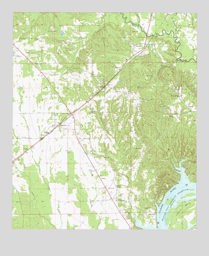
Catherine, AL USGS Topographic Map
Click on map above to begin viewing in our Map Viewer.

This topographic map contains these locations and features:
Feature Name Type Latitude Longitude GNIS ID View Map
AlbertaPopulated PlaceN32.2321°W87.4100°154963View Map
Alberta DivisionCivilN32.1417°W87.4162°165996View Map
Alberta Elementary SchoolSchoolN32.1415°W87.4186°138414View Map
Alberta Post OfficePost OfficeN32.2307°W87.4100°167601View Map
Antioch Church (historical)ChurchN32.1701°W87.3978°138416View Map
Bennett CemeteryCemeteryN32.1449°W87.4269°113919View Map
Bennett CemeteryCemeteryN32.1721°W87.4169°113920View Map
BethelPopulated PlaceN32.1410°W87.4750°138428View Map
Bethel ChurchChurchN32.2268°W87.4886°114025View Map
Boiling Spring CemeteryCemeteryN32.2396°W87.4700°114679View Map
Boiling Spring ChurchChurchN32.2207°W87.4850°114680View Map
Boiling SpringsPopulated PlaceN32.1343°W87.4683°159005View Map
CatherinePopulated PlaceN32.1846°W87.4694°115702View Map
Catherine AcademySchoolN32.1804°W87.4756°115703View Map
Catherine Census Designated PlaceCensusN32.1862°W87.4700°2628584View Map
Catherine Post OfficePost OfficeN32.1840°W87.4712°167600View Map
Cooper CemeteryCemeteryN32.2343°W87.4850°116572View Map
Dixie Grove ChurchChurchN32.1776°W87.4906°117311View Map
DonaldPopulated PlaceN32.2493°W87.3942°144553View Map
GastonburgPopulated PlaceN32.2074°W87.4375°118865View Map
Gastonburg CemeteryCemeteryN32.2135°W87.4394°118866View Map
Gastonburg ChurchChurchN32.1271°W87.4403°138473View Map
Gross CemeteryCemeteryN32.2062°W87.3853°119439View Map
Hobbs Bar (historical)BarN32.1410°W87.3967°138485View Map
Joe Harrison DamDamN32.1868°W87.4533°130255View Map
Joe Harrison LakeReservoirN32.1868°W87.4533°130254View Map
Kelly CemeteryCemeteryN32.2349°W87.4950°121115View Map
Little Chilatchee CreekStreamN32.2363°W87.3889°121735View Map
Macedonia ChurchChurchN32.2188°W87.4303°122145View Map
Malone CemeteryCemeteryN32.2068°W87.4147°122232View Map
Marsh CemeteryCemeteryN32.1662°W87.4378°122300View Map
Marsh CemeteryCemeteryN32.1774°W87.4514°122301View Map
Martin Field (historical)AirportN32.1585°W87.4500°129421View Map
Mill CreekStreamN32.1599°W87.3856°122750View Map
Mount Olive ChurchChurchN32.1488°W87.4314°123283View Map
Mount Sinia ChurchChurchN32.1482°W87.4056°138532View Map
Nixon and McGuire Bar (historical)BarN32.1501°W87.3800°138538View Map
PrairiePopulated PlaceN32.1540°W87.4400°156929View Map
Prairie BluffPopulated PlaceN32.1343°W87.4036°156930View Map
Prairie Bluff CemeteryCemeteryN32.1376°W87.4094°125233View Map
Prairie Bluff Landing (historical)LocaleN32.1268°W87.4014°138559View Map
Prairie Mission ChurchChurchN32.1418°W87.4278°125242View Map
RehobothPopulated PlaceN32.1957°W87.3814°156953View Map
Rehoboth CemeteryCemeteryN32.1918°W87.3905°125550View Map
Rogers CreekStreamN32.2429°W87.4144°125904View Map
Saint Marys ChurchChurchN32.1918°W87.4631°126163View Map
Salem ChurchChurchN32.1790°W87.4778°126236View Map
Shell Creek CemeteryCemeteryN32.1921°W87.4475°126674View Map
Spring Hill ChurchChurchN32.2418°W87.3769°127241View Map
Vincent SpringSpringN32.2021°W87.3875°128459View Map
Welcome CemeteryCemeteryN32.2137°W87.4044°128718View Map
Wilsor CemeteryCemeteryN32.2390°W87.4186°129103View Map
Young CemeteryCemeteryN32.1907°W87.3939°129307View Map
Zion ChurchChurchN32.1496°W87.4286°129333View Map
Zion ChurchChurchN32.1307°W87.4033°138623View Map

Note: Coordinates in the location and feature list above are referenced to NAD83 datum.


Copyright (C) 2008-2024 Ryan Niemi / Sunset Dynamics ... All Rights Reserved