TopoQuest Logo
Do you find TopoQuest useful?
Help keep TopoQuest running and adding new maps/features by donating!
Bitcoin:  19c7KJd3qBynnjoSw5npx9KScwjBe4ifkT
Litecoin:  LXs6TkuXGGXo1vDsWCkWVdjQX94eUKd6ui
Home View Maps Find Maps Find Places Resources & Links


Thomas, Texas Topographic Map

USGS Map Title: Thomas, TX
USGS Map MRC: 32095G1
DRG (GeoTIFF) Download: o32095g1.tif


Neighboring USGS Topographic Map Quads:


  Newsome, TX  
32095H2
 

  Leesburg, TX  
32095H1
 

  Pittsburg, TX  
32094H8
 

  Rhonesboro, TX  
32095G2
 

  Thomas, TX  
32095G1
 

  Bettie, TX  
32094G8
 

  Shady Grove, TX  
32095F2
 

  Pritchett, TX  
32095F1
 

  Gilmer, TX  
32094F8


Map MRC Location:

N33°
W96°
N33°
W95°
H8 H7 H6 H5 H4 H3 H2 H1
G8 G7 G6 G5 G4 G3 G2 G1
F8 F7 F6 F5 F4 F3 F2 F1
E8 E7 E6 E5 E4 E3 E2 E1
D8 D7 D6 D5 D4 D3 D2 D1
C8 C7 C6 C5 C4 C3 C2 C1
B8 B7 B6 B5 B4 B3 B2 B1
A8 A7 A6 A5 A4 A3 A2 A1
N32°
W96°
N32°
W95°

Thomas, TX USGS 1:24K Topographic Map Preview:
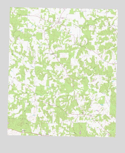
Thomas, TX USGS Topographic Map
Click on map above to begin viewing in our Map Viewer.

This topographic map contains these locations and features:
Feature Name Type Latitude Longitude GNIS ID View Map
Allen LakeReservoirN32.7635°W95.0319°1865345View Map
Allen Lake DamDamN32.7635°W95.0319°1865344View Map
Antioch ChurchChurchN32.8007°W95.1249°1329607View Map
Bear SpringsSpringN32.8293°W95.1202°1330250View Map
Beck BranchStreamN32.7915°W95.0958°1330280View Map
Caney CreekStreamN32.7974°W95.0511°1332093View Map
Copper BranchStreamN32.8262°W95.0488°1333327View Map
Crossroad CemeteryCemeteryN32.8576°W95.0077°1333729View Map
EnonPopulated PlaceN32.7707°W95.0297°1378266View Map
Enon BranchStreamN32.7940°W95.0238°1335477View Map
Enon ChurchChurchN32.7735°W95.0380°1335478View Map
GricePopulated PlaceN32.8062°W95.1191°1378386View Map
Grice CemeteryCemeteryN32.8021°W95.1222°1337021View Map
Hamberlin BranchStreamN32.7918°W95.0113°1337269View Map
Harmony ChurchChurchN32.7512°W95.0869°1337366View Map
Harmony Consolidated Volunteer Fire DepartmentBuildingN32.7537°W95.1060°2655418View Map
Harmony SchoolSchoolN32.7551°W95.1072°1337371View Map
Henderson LakeReservoirN32.7542°W95.0412°1865347View Map
Henderson Lake DamDamN32.7535°W95.0402°1865346View Map
Johnson BranchStreamN32.8079°W95.0338°1338776View Map
Prairie CreekStreamN32.7965°W95.0266°1344487View Map
RosewoodPopulated PlaceN32.7504°W95.0811°1378988View Map
SimpsonvillePopulated PlaceN32.8610°W95.0694°2034752View Map
Simpsonville CemeteryCemeteryN32.8626°W95.0697°1347159View Map
Soules ChapelPopulated PlaceN32.8307°W95.0744°2034726View Map
Soules ChapelLocaleN32.8310°W95.0733°1347393View Map
Stratford Branch LibraryBuildingN32.7787°W95.0633°2014780View Map
ThomasPopulated PlaceN32.8610°W95.0674°1379156View Map
Valley Spring ChurchChurchN32.8593°W95.0027°1349173View Map
Williams BranchStreamN32.7890°W95.0877°1350116View Map

Note: Coordinates in the location and feature list above are referenced to NAD83 datum.


Copyright (C) 2008-2025 Ryan Niemi / Sunset Dynamics ... All Rights Reserved