TopoQuest Logo
Do you find TopoQuest useful?
Help keep TopoQuest running and adding new maps/features by donating!
Bitcoin:  19c7KJd3qBynnjoSw5npx9KScwjBe4ifkT
Litecoin:  LXs6TkuXGGXo1vDsWCkWVdjQX94eUKd6ui
Home View Maps Find Maps Find Places Resources & Links


Bettie, Texas Topographic Map

USGS Map Title: Bettie, TX
USGS Map MRC: 32094G8
DRG (GeoTIFF) Download: o32094g8.tif


Neighboring USGS Topographic Map Quads:


  Leesburg, TX  
32095H1
 

  Pittsburg, TX  
32094H8
 

  Lafayette, TX  
32094H7
 

  Thomas, TX  
32095G1
 

  Bettie, TX  
32094G8
 

  Coffeeville, TX  
32094G7
 

  Pritchett, TX  
32095F1
 

  Gilmer, TX  
32094F8
 

  Glenwood, TX  
32094F7


Map MRC Location:

N33°
W95°
N33°
W94°
H8 H7 H6 H5 H4 H3 H2 H1
G8 G7 G6 G5 G4 G3 G2 G1
F8 F7 F6 F5 F4 F3 F2 F1
E8 E7 E6 E5 E4 E3 E2 E1
D8 D7 D6 D5 D4 D3 D2 D1
C8 C7 C6 C5 C4 C3 C2 C1
B8 B7 B6 B5 B4 B3 B2 B1
A8 A7 A6 A5 A4 A3 A2 A1
N32°
W95°
N32°
W94°

Bettie, TX USGS 1:24K Topographic Map Preview:
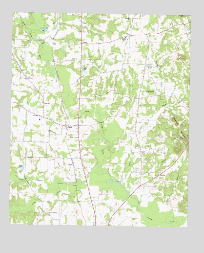
Bettie, TX USGS Topographic Map
Click on map above to begin viewing in our Map Viewer.

This topographic map contains these locations and features:
Feature Name Type Latitude Longitude GNIS ID View Map
Belton BranchStreamN32.7704°W94.9158°1330395View Map
BethlehemPopulated PlaceN32.8360°W94.9888°1378003View Map
BettiePopulated PlaceN32.8085°W94.9613°1330540View Map
Bettie DivisionCivilN32.8450°W95.0000°1938531View Map
Bishop CreekStreamN32.8171°W94.8999°1330719View Map
Bishop LakeReservoirN32.7829°W94.9122°1330720View Map
Blasingame BranchStreamN32.8015°W94.9352°1330858View Map
Brooks CreekStreamN32.7710°W94.9510°1331319View Map
Camp GilmontLocaleN32.8021°W94.8838°1331977View Map
Caney CreekStreamN32.7721°W94.9194°1332079View Map
Catfish BranchStreamN32.8651°W94.9877°1332332View Map
Cherokee Missionary ChurchChurchN32.7571°W94.9724°1332707View Map
ConcordPopulated PlaceN32.8254°W94.9108°1378150View Map
Concord Missionary ChurchChurchN32.8299°W94.9055°1333216View Map
DelrosePopulated PlaceN32.7857°W94.9560°1378208View Map
Denson CreekStreamN32.8571°W94.9791°1334259View Map
EwellPopulated PlaceN32.8626°W94.9169°1378277View Map
Ewell LakeReservoirN32.8410°W94.9505°1335591View Map
Ewell Lake DamDamN32.8418°W94.9502°1865352View Map
Ewell Volunteer Fire DepartmentBuildingN32.8634°W94.9117°2655417View Map
FriendshipPopulated PlaceN32.7807°W94.8952°1378334View Map
Gilmont LookoutLocaleN32.8026°W94.8791°1336537View Map
Grassy LakeLakeN32.8654°W94.9773°1336851View Map
Hefner BranchStreamN32.7535°W94.8833°1337558View Map
Holmes BranchStreamN32.7746°W94.9538°1337974View Map
Hopkins BranchStreamN32.8665°W94.9708°1338072View Map
Kelsey CreekStreamN32.7757°W94.9488°1374355View Map
Lilly CreekStreamN32.7765°W94.9274°1339921View Map
Lilly LakeLakeN32.8594°W94.9838°1339923View Map
Lone Mountain CemeteryCemeteryN32.7940°W94.9083°1340377View Map
Lone PinePopulated PlaceN32.8446°W94.9069°1378601View Map
Machen LakeReservoirN32.7834°W94.9913°1340808View Map
Machen Lake DamDamN32.7818°W94.9919°1865354View Map
MidwayPopulated PlaceN32.8576°W94.9519°1378677View Map
Oak Hill ChurchChurchN32.8201°W94.9938°1342991View Map
Olive BranchStreamN32.8399°W94.9755°1343254View Map
Poor CreekStreamN32.8207°W94.9610°1344357View Map
Smith SidingLocaleN32.8568°W94.9716°1347295View Map
Union HillPopulated PlaceN32.8143°W94.9805°1379194View Map
Union RidgeRidgeN32.8740°W94.9169°1349084View Map
Union Ridge ChurchChurchN32.8724°W94.9177°1349085View Map
Union Ridge Community CenterLocaleN32.8615°W94.9208°1349086View Map
Youngs ChapelChurchN32.8218°W94.9772°1350701View Map
Zion Hill CemeteryCemeteryN32.8443°W94.8974°1350754View Map
Zion Hill ChurchChurchN32.8440°W94.9022°1350762View Map

Note: Coordinates in the location and feature list above are referenced to NAD83 datum.


Copyright (C) 2008-2024 Ryan Niemi / Sunset Dynamics ... All Rights Reserved